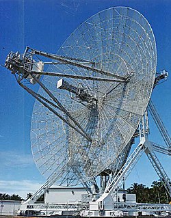
ALTAIR (Radar)

Last updated
ARPA Long-Range Tracking And Instrumentation Radar (ALTAIR) [1]
Radar antenna.jpg
Country of originUS
DesignerMIT Lincoln Laboratory
Introduced1969
Frequency162 and 422 mc
PRF 300 pps
Beamwidth 1.1° (UHF)
2.8° (VHF)
Pulsewidth80 µsec
Range42,000 km
Diameter45.7 m (150 ft)
Precision20 m (66 ft)
Power5 MW

ALTAIR (ARPA Long-Range Tracking And Instrumentation Radar) is a radar tracking station on Roi-Namur island in the north part of the Kwajalein atoll in the Marshall Islands. It is a high-sensitivity, wide-bandwidth, coherent, instrumentation and tracking radar that is capable of collecting precise measurements on small targets at long-ranges. ALTAIR supports several operating modes, including tracking and signature collection at VHF and UHF. It is part of a network of contributing radar sensors that perform deep-space tracking. [2]

The antenna uses a steerable 150-ft dish (46-m-diameter) and employs a focal point VHF feed and multimode Cassegrain UHF feed in conjunction with a frequency selective sub-reflector (5.5 m diameter). [3]

The radar became operational in 1969. [4] The original task was to detect and track intercontinental ballistic missiles. It is currently used to measure satellite orbits and meteor echoes in low-Earth orbit, [5] and to observe ionospheric irregularities and background densities. [6]

Related Research Articles

<span class="mw-page-title-main">Ionosphere</span> Ionized part of Earths upper atmosphere

The ionosphere is the ionized part of the upper atmosphere of Earth, from about 48 km (30 mi) to 965 km (600 mi) above sea level, a region that includes the thermosphere and parts of the mesosphere and exosphere. The ionosphere is ionized by solar radiation. It plays an important role in atmospheric electricity and forms the inner edge of the magnetosphere. It has practical importance because, among other functions, it influences radio propagation to distant places on Earth. It also affects GPS signals that travel through this layer.

<span class="mw-page-title-main">Communications satellite</span> Artificial satellite that relays radio signals

A communications satellite is an artificial satellite that relays and amplifies radio telecommunication signals via a transponder; it creates a communication channel between a source transmitter and a receiver at different locations on Earth. Communications satellites are used for television, telephone, radio, internet, and military applications. Many communications satellites are in geostationary orbit 222,300 miles (357,800 km) above the equator, so that the satellite appears stationary at the same point in the sky; therefore the satellite dish antennas of ground stations can be aimed permanently at that spot and do not have to move to track the satellite. Others form satellite constellations in low Earth orbit, where antennas on the ground have to follow the position of the satellites and switch between satellites frequently.

<span class="mw-page-title-main">High-frequency Active Auroral Research Program</span> Project to analyze the ionosphere

The High-frequency Active Auroral Research Program (HAARP) is a University of Alaska Fairbanks program which researches the ionosphere – the highest, ionized part of Earth's atmosphere.

Anomalous propagation includes different forms of radio propagation due to an unusual distribution of temperature and humidity with height in the atmosphere. While this includes propagation with larger losses than in a standard atmosphere, in practical applications it is most often meant to refer to cases when signal propagates beyond normal radio horizon.

TV DX and FM DX is the active search for distant radio or television stations received during unusual atmospheric conditions. The term DX is an old telegraphic term meaning "long distance."

<span class="mw-page-title-main">Explorer 6</span> NASA satellite of the Explorer program

Explorer 6, or S-2, was a NASA satellite, launched on 7 August 1959, at 14:24:20 GMT. It was a small, spheroidal satellite designed to study trapped radiation of various energies, galactic cosmic rays, geomagnetism, radio propagation in the upper atmosphere, and the flux of micrometeorites. It also tested a scanning device designed for photographing the Earth's cloud cover. On 14 August 1959, Explorer 6 took the first photos of Earth from a satellite.

<span class="mw-page-title-main">United States Space Surveillance Network</span> SSA system

The United States Space Surveillance Network (SSN) detects, tracks, catalogs and identifies artificial objects orbiting Earth, e.g. active/inactive satellites, spent rocket bodies, or fragmentation debris. The system is the responsibility of United States Space Command and operated by the United States Space Force and it's functions are:

Polar mesospheric summer echoes (PMSE) is the phenomenon of anomalous radar echoes found between 80 and 90 km in altitude from May through early August in the Arctic, and from November through to February in the Antarctic. These strong radar echoes are associated with the extremely cold temperatures that occur above continental Antarctica during the summer. Rocket and radar measurements indicate that a partial reflection from a multitude of ion layers and constructive interference causes at least some of the PMSE.

<span class="mw-page-title-main">Haystack Observatory</span> American microwave observatory owned by MIT

Haystack Observatory is a multidisciplinary radio science center, ionospheric observatory, and astronomical microwave observatory owned by Massachusetts Institute of Technology (MIT). It is in Westford, Massachusetts, in the United States, about 45 kilometers (28 mi) northwest of Boston. The observatory was built by MIT's Lincoln Laboratory for the United States Air Force and was called the Haystack Microwave Research Facility. Construction began in 1960, and the antenna began operating in 1964. In 1970 the facility was transferred to MIT, which then formed the Northeast Radio Observatory Corporation (NEROC) with other universities to operate the site as the Haystack Observatory. As of January 2012, a total of nine institutions participated in NEROC.

<span class="mw-page-title-main">Super Dual Auroral Radar Network</span>

The Super Dual Auroral Radar Network (SuperDARN) is an international scientific radar network consisting of 35 high frequency (HF) radars located in both the Northern and Southern Hemispheres. SuperDARN radars are primarily used to map high-latitude plasma convection in the F region of the ionosphere, but the radars are also used to study a wider range of geospace phenomena including field aligned currents, magnetic reconnection, geomagnetic storms and substorms, magnetospheric MHD waves, mesospheric winds via meteor ionization trails, and interhemispheric plasma convection asymmetries. The SuperDARN collaboration is composed of radars operated by JHU/APL, Virginia Tech, Dartmouth College, the Geophysical Institute at the University of Alaska Fairbanks, the Institute of Space and Atmospheric Studies at the University of Saskatchewan, the University of Leicester, Lancaster University, La Trobe University, the Solar-Terrestrial Environment Laboratory at Nagoya University, the British Antarctic Survey and the Institute for Space Astrophysics and Planetology.

<span class="mw-page-title-main">Medicina Radio Observatory</span> Astronomical observatory near Bologna, Italy

The Medicina Radio Observatory is an astronomical observatory located 30 km from Bologna, Italy. It is operated by the Institute for Radio Astronomy of the National Institute for Astrophysics (INAF) of the government of Italy.

Pirinçlik Air Base, also known as Pirinçlik Air Station, formerly Diyarbakır Air Station, was a 41-year-old American-Turkish military base near Diyarbakir, Turkey. Notable base commanders include Col. Dale Lee Norman. It was known as NATO's frontier post for monitoring the former Soviet Union and the Middle East, completely closed on 30 September 1997.

<span class="mw-page-title-main">Total electron content</span>

Total electron content (TEC) is an important descriptive quantity for the ionosphere of the Earth. TEC is the total number of electrons integrated between two points, along a tube of one meter squared cross section, i.e., the electron columnar number density. It is often reported in multiples of the so-called TEC unit, defined as TECU=1016el/m21.66×10−8 mol⋅m−2.

<span class="mw-page-title-main">C/NOFS</span>

C/NOFS, or Communications/Navigation Outage Forecasting System was a USAF satellite developed by the Air Force Research Laboratory (AFRL) Space Vehicles Directorate to investigate and forecast scintillations in the Earth's ionosphere. It was launched by an Orbital Sciences Corporation Pegasus-XL launch vehicle at 17:02:48 UTC on 16 April 2008 and decayed on 28 November 2015.

(450894) <span class="nowrap">2008 BT<sub>18</sub></span>

(450894) 2008 BT18 is a sub-kilometer asteroid and synchronous binary system, classified as near-Earth object and potentially hazardous asteroid of the Apollo group. It was discovered on 31 January 2008, by the LINEAR program at Lincoln Laboratory's Experimental Test Site near Socorro, New Mexico, United States. The eccentric asteroid measures approximately 600 meters in diameter and has a composition of a basaltic achondrite.

<span class="mw-page-title-main">Jicamarca Radio Observatory</span>

The Jicamarca Radio Observatory (JRO) is the equatorial anchor of the Western Hemisphere chain of Incoherent Scatter Radar (ISR) observatories extending from Lima, Peru to Søndre Strømfjord, Greenland. JRO is the premier scientific facility in the world for studying the equatorial ionosphere. The observatory is about half an hour drive inland (east) from Lima and 10 km from the Central Highway. The magnetic dip angle is about 1°, and varies slightly with altitude and year. The radar can accurately determine the direction of the Earth's magnetic field (B) and can be pointed perpendicular to B at altitudes throughout the ionosphere. The study of the equatorial ionosphere is rapidly becoming a mature field due, in large part, to the contributions made by JRO in radio science.

<span class="mw-page-title-main">Millstone Hill</span>

The Millstone Hill Steerable Antenna, or MISA, is a fully steerable dish antenna, 46 metres (151 ft) in diameter, designed by the Stanford Research Institute (SRI) in 1959. It is currently located at MIT Haystack Observatory in Westford, Massachusetts.

<span class="mw-page-title-main">Unified S-band</span> Tracking and communication system developed by NASA and JPL

The Unified S-band (USB) system is a tracking and communication system developed for the Apollo program by NASA and the Jet Propulsion Laboratory (JPL). It operated in the S band portion of the microwave spectrum, unifying voice communications, television, telemetry, command, tracking and ranging into a single system to save size and weight and simplify operations. The USB ground network was managed by the Goddard Space Flight Center (GSFC). Commercial contractors included Collins Radio, Blaw-Knox, Motorola and Energy Systems.

<span class="mw-page-title-main">Explorer 20</span> NASA satellite of the Explorer program

Explorer 20, also known Ionosphere Explorer-A, IE-A, S-48, TOPSI and Topside Explorer, was a NASA satellite launched as part of Explorer program. Its purpose was two-fold: long-term investigation of the ionosphere from above, and in situ investigation of ion concentrations and temperatures.

<span class="nowrap">(85990) 1999 JV<sub>6</sub></span> Asteroid

(85990) 1999 JV6 (provisional designation 1999 JV6) is a sub-kilometer near-Earth asteroid and a potentially hazardous object of the Apollo group. It was discovered by astronomers of the LINEAR program at the Lincoln Laboratory's Experimental Test Site near Socorro, New Mexico. 1999 JV6 is a contact binary object consisting of two distinct lobes, as seen in radar images from various observatories including Arecibo and Goldstone in January 2015.

References

  1. J. A. Nelson and K. R. Roth, History of Lincoln Laboratory at the Reagan Test Site, Lincoln Laboratory Journal Number 2 2012 (online PDF)
  2. Card Index of Radar Sets in Radartutorial
  3. S. Close, S. M. Hunt, F. M. McKeen and M. J. Minardi: “Characterization of Leonid meteor head echo data collected using the VHF-UHF Advanced Research Projects Agency Long-Range Tracking and Instrumentation Radar (ALTAIR)”, MIT Lincoln Laboratory, Lexington, Massachusetts, USA, in RADIO SCIENCE, VOL. 37, NO. 1, 1009, 10.1029/2000RS002602, 2002 (online PDF)
  4. Sidney G. Reed, Richard H. Van Atta und Seymour J. Deitchman DARPA technical accomplishments : an historical review of selected DARPA projects, Institute for Defense Analyses, Alexandria, Va. und [1990-1991]
  5. Sigrid Close et al.: “Simultaneous dual-frequency observations of meteor head echoes using ALTAIR”, In: Proceedings of the Third European Conference on Space Debris, 19–21 March 2001, Darmstadt, Germany. Ed.: Huguette Sawaya-Lacoste. ESA SP-473, Vol. 1, Noordwijk, Netherlands: ESA Publications Division, ISBN 92-9092-733-X, 2001, p. 237 - 242 (online PDF)
  6. D.M.Towle: "VHF and UHF radar observations of equatorial F region ionospheric irregularities and background densities", Lincoln Laboratory, Massachusetts Institute of Technology, Lexington, Massachusetts 02173, in Radio Science 1980, p. 71 ()

Creative Commons by-sa small.svg  This article incorporates text available under the CC BY-SA 3.0 license.