Glossop is a market town in the Borough of High Peak, Derbyshire, England, 15 miles (24 km) east of Manchester, 24 miles (39 km) north-west of Sheffield and 32 miles (51 km) north of the county town, Matlock, near Derbyshire's borders with Cheshire, Greater Manchester, South Yorkshire and West Yorkshire. It is between 150 and 300 metres above mean sea level, and is bounded by the Peak District National Park to the south, east and north.

Basingwerk Abbey is a Grade I listed ruined abbey near Holywell, Flintshire, Wales. The abbey, which was founded in the 12th century, belonged to the Order of Cistercians. It maintained significant lands in the English county of Derbyshire. The abbey was abandoned and its assets sold following the Dissolution of the Monasteries in 1536.
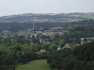
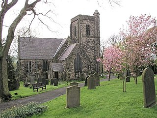
Gamesley is a residential area within the Borough of High Peak in Derbyshire, England, west of Glossop and close to the River Etherow which forms the boundary with Tameside in Greater Manchester. Gamesley is a ward of the High Peak Borough Council. It had a population of 2,531 at the 2011 Census.

High Peak is a local government district with borough status in Derbyshire, England. The borough compromises high moorland plateau in the Dark Peak area of the Peak District National Park. The district stretches from Holme Moss in the north to Sterndale Moor in the south and from Hague Bar in the west to Bamford in the east. The population of the borough taken at the 2011 Census was 90,892. The borough is unusual in having two administrative centres for its council, High Peak Borough Council. The offices are based in both Buxton and Glossop. The borough also contains other towns including Chapel-en-le-Frith, Hadfield, New Mills and Whaley Bridge.

Hadfield is a town in the High Peak of Derbyshire, England. The population of the town's wards in the 2011 Census was 6,305. It lies on the south side of the River Etherow, the border between Derbyshire and Greater Manchester, at the western edge of the Peak District close to Glossop.

High Peak is a parliamentary constituency represented in the House of Commons of the UK Parliament since 2019 by Robert Largan, a Conservative.
Glossop North End Association Football Club is a football club in Glossop, Derbyshire, England. Formerly members of the Football League, they currently play in the Northern Premier League Division One West and are members of the Derbyshire County Football Association. Their home ground is Surrey Street, which has a capacity of 1,301. The club play in blue, and are nicknamed the Hillmen or the Peakites. Between 1899 and 1992 the club was officially known simply as Glossop.

Win Hill is a hill north west of Bamford in the Derbyshire Peak District of England. Its summit is 462 m (1,516 ft) above sea level and it is bounded by the River Derwent to the east, the River Noe to the south west and Ladybower Reservoir to the north, with a ridge running north west linking it to Kinder Scout. The Roman road from Glossop over the Snake Pass crosses the ridge to the north and descends to Hope and the old Roman base of Brough in the Hope Valley, with the Hope Cross, a marker post dating from 1737, at the highest point of the road.

Snake Pass is a hill pass in the Derbyshire section of the Peak District, crossing the Pennines between Glossop and the Ladybower Reservoir at Ashopton. The road was engineered by Thomas Telford and opened in 1821. The pass carries the A57 road between Manchester and Sheffield, but it is no longer the main signposted route between those two cities, with traffic instead directed through the Woodhead Pass to the north.

Brough and Shatton is a civil parish in Hope Valley in the High Peak district of Derbyshire, England. It is named for the two hamlets of Brough-on-Noe and Shatton. Brough is about 2 km, or just over 1 mile, west (upstream) of Shatton; both are on the River Noe, a tributary of the upper River Derwent. They lie within the Peak District National Park, about 15 miles west of Sheffield and 30 miles east of Manchester. According to the 2011 census, Brough and Shatton had a combined population of 136. There is a friendly rivalry between the two hamlets, which contest numerous sports competitions throughout the year.

Simmondley is a small village near the town of Glossop in Derbyshire, England. The population of the High Peak ward at the 2011 Census was 4,727. It has one pub, the Hare and Hounds, in the south of the village at the top of Simmondley Lane. The pub is a part of the original farming community with the adjacent farmhouse, barn and stables converted into houses. The Jubilee pub was built in 1977, in celebration of the Silver Jubilee of Elizabeth II. After 40 years, the brewery that owned the Jubilee sold it at auction; the buyer demolished the building in 2017 to build houses on the site and adjoining car park.
Broadbottom railway station serves the village of Broadbottom in Greater Manchester, England. It is on the Manchester-Glossop Line, 10 miles (16 km) east of Manchester Piccadilly. It was opened by the Sheffield, Ashton-Under-Lyne and Manchester Railway in 1842. It was renamed "Mottram" in 1845, but has since reverted to its original name.

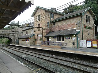
Dinting railway station serves the village of Dinting near Glossop in Derbyshire, England. The station is on the Manchester-Glossop Line, 12+1⁄4 miles (19.7 km) east of Manchester Piccadilly. Prior to the Woodhead Line closure in 1981, Dinting was a station on a major cross-Pennine route.

Glossop Hall was the last residential building on the site of Royle Hall in Glossop, Derbyshire.
Charlesworth is a village and civil parish near Glossop, Derbyshire, England. The population of the civil parish at the 2011 Census was 2,449. It is 2 miles (3.2 km) south-west of Glossop town centre and close to the borders of Greater Manchester with the nearby village of Broadbottom in Tameside. The parish church of St John the Baptist was built in 1848–49. The Congregational Chapel was rebuilt from an earlier chapel in 1797. The Baptist Chapel was built in 1835. Broadbottom Bridge, one end of which is in Cheshire, was built in 1683. Charlesworth holds an annual carnival on the second Saturday in July on its recreation ground on Marple Road, which includes fell races and other events.

Chisworth is a hamlet near Glossop, Derbyshire, England. It is 3 miles (4.8 km) south-west of Glossop town centre, on the south side of the Etherow valley. The parish of Chisworth was formed in 1896, out of the parish of Chisworth and Ludworth. In 1901, it had a population of 409. From 1896 until 1934 it was in the Glossop Rural District, when it was placed with Ludworth into the Chapel en le Frith Rural District. The village possesses a Methodist chapel. The A626 road passes through the hamlet. In June 1930, a local cloudburst caused flooding that killed one man and destroyed equipment at the mills, one of which never reopened.

Whitfield is a hamlet and former parish in Derbyshire, England. It is located a half mile (1km) south of Glossop Town Hall, south of Glossop Brook between Bray Clough and Hurst Brook. The name Whitfield in Anglo-Saxon times meant 'bright or white pasture or field', up to the latter part of the 18th century the hamlet was devoted mostly to agriculture with an area of 2,608 statute acres. Whitfield was one of the original townships in the ancient Parish of Glossop, and the manor, the area rose in altitude from approximately 490 to 985 feet above mean sea level. The urban area currently covers about a half mile (1km), built across a hillside and is situated in the upper part is part of the Peak District National Park. The highest point is Mill Hill at 1,785 feet on the Pennine Way, 2 miles from Whitfield.
Glossopdale is the area around Glossop, Derbyshire, England, the valley of the Glossop Brook.

Ashton-under-Lyne bus station is a bus station that is located in the town of Ashton-under-Lyne in Greater Manchester, run by Transport for Greater Manchester. The bus station is situated on Wellington Road and adjoins the Arcades Shopping Centre. The bus station was opened in 2020 and replaced the previous bus station that was built on the current site.

Glossop was a Municipal Borough in Derbyshire, England from 1866 to 1974. It was created under the Municipal Corporations Act 1835.
