
Glossop is a market town in the borough of High Peak, Derbyshire, England, 15 miles (24 km) east of Manchester, 24 miles (39 km) north-west of Sheffield and 32 miles (51 km) north of Matlock. Near Derbyshire's borders with Cheshire, Greater Manchester, South Yorkshire and West Yorkshire, between 150 and 300 metres above sea level, it is bounded by the Peak District National Park to the south, east and north. In 2021, it had a population of 17,825.

The River Etherow in northern England is a tributary of the River Goyt. Although now passing through South Yorkshire, Derbyshire and Greater Manchester, it historically formed the ancient county boundary between Cheshire and Derbyshire. The upper valley is known as Longdendale. The river has a watershed of approximately 30 square miles (78 km2), and the area an annual rainfall of 52.5 inches (1,330 mm).

High Peak is a local government district with borough status in Derbyshire, England, covering a high moorland plateau in the Dark Peak area of the Peak District National Park. The district stretches from Holme Moss in the north to Sterndale Moor in the south, and from Hague Bar in the west to Bamford in the east. The population of the borough taken at the 2011 Census was 90,892. The borough is unusual in having two administrative centres for its council, High Peak Borough Council; the offices are in Buxton and Glossop. Other towns include Chapel-en-le-Frith, Hadfield, New Mills and Whaley Bridge.

Hadfield is a town in the High Peak of Derbyshire, England, with a population at the 2021 Census of 6,763. It lies on the south side of the River Etherow, near to the border with Greater Manchester, at the western edge of the Peak District close to Glossop. It doubled as the fictional town of Royston Vasey in the BBC comedy series The League of Gentlemen.

The Abbot's Chair is the common name of a former monastic cross, the Charlesworth Cross. Only the socket remains of this boundary cross, built by the monks of Basingwerk Abbey in North Wales. Henry II of England gave the manor of Glossop to the monks, and they gained a market charter for Glossop in 1290, and one for Charlesworth in 1328. In 1433 the monks leased all of Glossopdale to the Talbot family, later Earls of Shrewsbury.
Dinting is a village in the High Peak district of Derbyshire, England. It is situated near the towns of Glossop and Hadfield. There is a small primary school, Dinting C of E, located near the viaduct. The 1st Dinting Scout Group has been active since 1938.

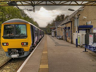
Dinting railway station serves the village of Dinting in Derbyshire, England. It is a stop on the Glossop line and, prior to the Woodhead Line's closure in 1981, Dinting was a station on the Great Central Main Line between Manchester Piccadilly and Sheffield Victoria.
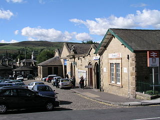
Hadfield railway station serves the Peak District town of Hadfield in Derbyshire, England. The station is one of the twin termini at the Derbyshire end of the Manchester-Glossop Line, the other being Glossop. It was opened by the Sheffield, Ashton-under-Lyne and Manchester Railway in 1844.
Glossop railway station serves the Peak District town of Glossop in Derbyshire, England. Glossop is the third busiest railway station in the county of Derbyshire after Derby and Chesterfield. It is located just north of Norfolk Square in the centre of Glossop.
Speedwellbus was a bus operator based in Hyde, Greater Manchester, England. It operated a fleet of 25 buses on commercial and contracted services. Formed in 2002, it ceased operating rather abruptly and unexpectedly in January 2012 due to financial problems and nearly having had its licence revoked.

Padfield is a small village near Hadfield in High Peak, Derbyshire, England. The village is on the west side of the Peak District National Park, and the nearest town is Glossop, where many local amenities and services are based. It is in a conservation area. The population as of the 2011 census was 2,796.
Glossopdale School is a mixed secondary school and sixth form located in Hadfield, Derbyshire, England.

Whitfield is a hamlet and former parish in Derbyshire, England. It is half a mile (1km) south of Glossop Town Hall, south of Glossop Brook between Bray Clough and Hurst Brook. Whitfield was one of the original townships in the ancient Parish of Glossop. Up to the latter part of the 18th century the hamlet was devoted mostly to agriculture with an area of 2,608 statute acres.
Francis James Sumner was a Roman Catholic mill owner in Glossop. Sumner built a large business and served as Mayor of Glossop, and Deputy Lieutenant and High Sheriff of Derbyshire.
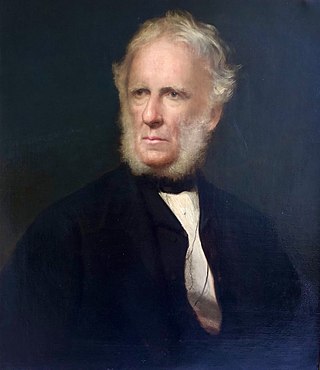
Edmund Potter (1802–1883) was a Manchester industrialist and MP and grandfather to Beatrix Potter.
Higher Dinting is a village in Glossopdale, Derbyshire, England. The village is near Glossop, Dinting, and Dinting Vale; the village falls within the Simmondley ward of the High Peak Council.
Dinting Vale is a village in Glossopdale, Derbyshire, England. The Vale falls within the Simmondley ward of the High Peak Council. Dinting Vale lies near to Higher Dinting, Dinting, Brookfield and Glossop.

Woolley Bridge is an area in Glossopdale, on the border of Greater Manchester and Derbyshire in England. It lies 10 miles from Manchester city centre. It is in the ward of Hadfield South. Nearby places include Hollingworth, Dinting Vale, Gamesley, Glossop and Mottram.

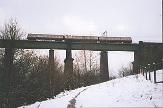
Dinting Viaduct is a 19th-century railway viaduct in Glossopdale in Derbyshire, England, that carries the Glossop Line over a valley at the village of Dinting. It crosses the Glossop Brook and the A57 road between Manchester and Sheffield.