Related Research Articles

Glossop is a market town in the borough of High Peak, Derbyshire, England, 15 miles (24 km) east of Manchester, 24 miles (39 km) north-west of Sheffield and 32 miles (51 km) north of Matlock. Near Derbyshire's borders with Cheshire, Greater Manchester, South Yorkshire and West Yorkshire, between 150 and 300 metres above sea level, it is bounded by the Peak District National Park to the south, east and north. In 2021, it had a population of 17,825.

High Peak is a local government district with borough status in Derbyshire, England, covering a high moorland plateau in the Dark Peak area of the Peak District National Park. The district stretches from Holme Moss in the north to Sterndale Moor in the south, and from Hague Bar in the west to Bamford in the east. The population of the borough taken at the 2011 Census was 90,892. The borough is unusual in having two administrative centres for its council, High Peak Borough Council; the offices are in Buxton and Glossop. Other towns include Chapel-en-le-Frith, Hadfield, New Mills and Whaley Bridge.

Hadfield is a town in the High Peak of Derbyshire, England, with a population at the 2021 Census of 6,763. It lies on the south side of the River Etherow, near to the border with Greater Manchester, at the western edge of the Peak District close to Glossop. It doubled as the fictional town of Royston Vasey in the BBC comedy series The League of Gentlemen.

Blackwell is a village in the Derbyshire Dales local government district of Derbyshire, England, on the A6 main road between Bakewell and Buxton.

Ballidon is a village and civil parish in the Derbyshire Dales district of Derbyshire, England, on the edge of the Peak District National Park. According to the 2001 census it had a population of 79. The population at the 2011 Census remained less than 100. Details are maintained in the civil Parish of Aldwark, Derbyshire.

Brough and Shatton is a civil parish in Hope Valley in the High Peak district of Derbyshire, England. It is named for the two hamlets of Brough-on-Noe and Shatton. Brough is about 2 km, or just over 1 mile, west (upstream) of Shatton; both are on the River Noe, a tributary of the upper River Derwent. They lie within the Peak District National Park, about 15 miles west of Sheffield and 30 miles east of Manchester. According to the 2011 census, Brough and Shatton had a combined population of 136. There is a friendly rivalry between the two hamlets, which contest numerous sports competitions throughout the year.

Brushfield is a hamlet and civil parish in the Derbyshire Dales district of Derbyshire, England, in the Peak District National Park. It is about 8 miles east of Buxton. According to the 2001 census it had a population of 13. In 2007 it had just three houses. Several holiday lets are run by two separate families. One of these cottages is called the 'Old School House', a small one-bed house of stone.
Dinting is a village in the High Peak district of Derbyshire, England. It is situated near the towns of Glossop and Hadfield. There is a small primary school, Dinting C of E, located near the viaduct. The 1st Dinting Scout Group has been active since 1938.

Chew Valley in Saddleworth, Greater Manchester, England, follows the course of Chew Brook on the western slopes of Black Chew Head to where it joins the River Tame at Greenfield, east of Manchester. Part of the higher fringes of the valley towards the peak of Black Chew Head lie across the boundary in Derbyshire. The eastern part of the valley including the reservoirs of Dovestone and Chew are within the north western extremity of the Peak District National Park.

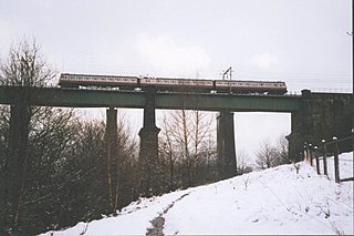
Dinting railway station serves the village of Dinting in Derbyshire, England. It is a stop on the Glossop line and, prior to the Woodhead Line's closure in 1981, Dinting was a station on the Great Central Main Line between Manchester Piccadilly and Sheffield Victoria.
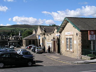
Glossop railway station serves the Peak District town of Glossop in Derbyshire, England. Glossop is the third busiest railway station in the county of Derbyshire after Derby and Chesterfield. It is located just north of Norfolk Square in the centre of Glossop.

Bamford Edge is an overhang of gritstone rock that sticks out north of the village of Bamford, Hope Valley, in the English county of Derbyshire. The first ascent of "Smoked Salmon", which is graded as E8 7b was made by British climber Johnny Dawes.

Padfield is a small village near Hadfield in High Peak, Derbyshire, England. The village is on the west side of the Peak District National Park, and the nearest town is Glossop, where many local amenities and services are based. It is in a conservation area. The population as of the 2011 census was 2,796.
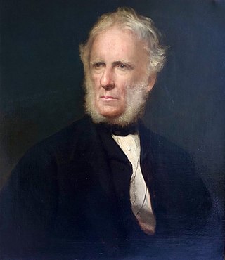
Edmund Potter (1802–1883) was a Manchester industrialist and MP and grandfather to Beatrix Potter.
Higher Dinting is a village in Glossopdale, Derbyshire, England. The village is near Glossop, Dinting, and Dinting Vale; the village falls within the Simmondley ward of the High Peak Council.
Glossopdale is the area around Glossop, Derbyshire, England, the valley of the Glossop Brook.
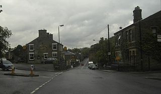
Charlestown is a village in Glossopdale, Derbyshire, England. It is in the Simmondley Ward of the High Peak District Council. The village is situated on the A624 road between Glossop and Hayfield.

Woolley Bridge is an area in Glossopdale, on the border of Greater Manchester and Derbyshire in England. It lies 10 miles from Manchester city centre. It is in the ward of Hadfield South. Nearby places include Hollingworth, Dinting Vale, Gamesley, Glossop and Mottram.

The Goyt Way is a 10-mile (16 km) walking route from Etherow Country Park, Greater Manchester, to Whaley Bridge, Derbyshire, following the valley of the River Goyt. It is part of the longer Midshires Way, which in turn is part of the E2 European long-distance path. The path is waymarked, and intersects with the Cheshire Ring Canal Walk and the Peak District Boundary Walk. It passes through the following settlements: Compstall, Marple, Strines, Brookbottom, Hague Bar, New Mills and Furness Vale. In its latter stages, it follows the towpath of the Peak Forest Canal to its terminus at Whaley Bridge.
References
- ↑ Ordnance Survey: Landranger map sheet 110 Sheffield & Huddersfield (Glossop & Holmfirth) (Map). Ordnance Survey. 2012. ISBN 9780319231876.
- ↑ "Ordnance Survey: 1:50,000 Scale Gazetteer" (csv (download)). www.ordnancesurvey.co.uk. Ordnance Survey. 1 January 2016. Retrieved 18 February 2016.
53°26′58″N1°58′41″W / 53.4494°N 1.9781°W
| | This Derbyshire location article is a stub. You can help Wikipedia by expanding it. |