
Llansantffraed (Llansantffraed-juxta-Usk) is a parish in the community of Talybont-on-Usk in Powys, Wales, near Brecon. The benefice of Llansantffraed with Llanrhystud and Llanddeiniol falls within the Diocese of St Davids in the Church in Wales.

Treberfydd House is a Gothic Revival house, built in 1847–50 just south of Llangorse Lake in the Brecon Beacons National Park in South Wales, to the designs of architect John Loughborough Pearson. It remains a private home to the Raikes family and is a Grade I listed building. The gardens are listed on the Cadw/ICOMOS Register of Parks and Gardens of Special Historic Interest in Wales.
Trallong is a village and community in Powys, Wales, in the historic county of Brecknockshire.

In the United Kingdom, the term listed building refers to a building or other structure officially designated as being of special architectural, historical, or cultural significance; Grade I structures are those considered to be "buildings of exceptional interest". Listing was begun by a provision in the Town and Country Planning Act 1947. Once listed, strict limitations are imposed on the modifications allowed to a building's structure or fittings. In Wales, the authority for listing under the Planning Act 1990 rests with Cadw.

Penoyre House, Battle, Powys, Wales is a nineteenth century country house. Designed by Anthony Salvin for Colonel John Lloyd Vaughan Watkins, it was built between 1846-8. In an Italianate style, it is described by Mark Girouard as "Salvin's most ambitious classical house". The enormous cost of the house almost bankrupted the family and it was sold only 3 years after Colonel Watkins's death. From 1947, the house was in institutional use, and was converted to apartments in the early twenty-first century. The building is Grade II* listed The gardens are listed Grade II on the Cadw/ICOMOS Register of Parks and Gardens of Special Historic Interest in Wales.

The Church of St Issui, Partrishow, Powys, Wales, is a Grade I listed parish church dating from 1060. The existing building was mainly constructed in the 14th and 15th centuries and was sensitively restored in 1908–1909. The church is most famous for its rood screen which dates from 1500. It is a Grade I listed building.

Penpont is a seventeenth-century Grade I listed manor house in the Usk valley between Brecon and Sennybridge in Powys, Wales. It was built by Daniel Williams on the site of, and perhaps incorporating, an earlier house, Abercamlais-isaf. The frontage dates from 1815. Penpont Bridge, a grade II* listed structure, spans the Usk by means of four segmented stone arches. The gardens at Penpont are influenced by Repton but have a long history from the seventeenth century with the addition of a celebrated Green Man maze in recent years. They are listed Grade II* on the Cadw/ICOMOS Register of Parks and Gardens of Special Historic Interest in Wales.

The farm at Great Porthamel, at Talgarth in Powys, Wales, comprises a range of buildings including the farmhouse, the gate tower and an agricultural building. They form the remnants of a major medieval manor that was the principal seat of the Vaughan family. The complex has been described as "one of the more remarkable mediaeval houses of Wales". The gatehouse is a Grade I listed building, and a scheduled monument, while the farmhouse is listed at Grade II* and the agricultural building at Grade II.

Harpton Court, Old Radnor, Powys, is a Tudor Revival house dating from the late 19th century. It originally formed the north-west wing to a much larger Neoclassical mansion, which was reconstructed by John Nash in the early 19th century, but the main part of the court was demolished in 1956. The house was the ancestral home of the Lewis family, whose most prominent member, George Cornewall Lewis, served as Chancellor of the Exchequer and Home Secretary under Lord Palmerston. The court remains a private house and is a Grade II listed building. Its gardens and grounds are listed on the Cadw/ICOMOS Register of Parks and Gardens of Special Historic Interest in Wales.

Old Gwernyfed is a house dating from the medieval period in the community of Gwernyfed, Powys, Wales, close to the village of Felindre. It remains a private home and is a Grade I listed building. The gardens are listed on the Cadw/ICOMOS Register of Parks and Gardens of Special Historic Interest in Wales.

The Old Vicarage is a house dating from the medieval period in the community of Glasbury, Powys, Wales. Now a private house, it is a Grade I listed building.

Scethrog Tower stands to the south of the hamlet of Scethrog, in the Usk valley between Brecon and Crickhowell, in Powys, Wales. A tower house dating from the 14th century, in the late 20th century it was the country home of the musician and critic, George Melly. It is a Grade I listed building.

Porth-Mawr is a gatehouse on Brecon Street in the centre of Crickhowell, Powys, Wales. Constructed in the 15th century by a branch of the Herbert family as the entrance to their Tudor mansion of Cwrt Carw, it is a Grade I listed building.

St David's Church is an active parish church in the village of Llanddew, Powys, Wales. It stands next to the castle, some 2km to the north-east of Brecon. It is traditionally associated with Gerald of Wales, who served as Archdeacon of Brecon and lived in the castle in the late 12th century. Ruined by the mid-19th century, the church was restored by Ewan Christian. St David's is designated by Cadw as a Grade I listed building.
St Matthew's Church, is an active parish church in the village of Llandefalle, Felin-fach, Powys, Wales. Dating from the 15th century, the church was restored, probably by W. D. Caröe, in the early 20th century. St Matthew's is designated by Cadw as a Grade I listed building.

St Bilo's Church, is an active parish church in the village of Llanfilo, Felin-fach, Powys, Wales. The dedication is to Bilo, one of the 24 children of Brychan, a legendary 5th-century king of Brycheiniog. Dating from the 12th century, with later additions, the church was restored by W. D. Caröe in the early 20th century. St Bilo's is designated by Cadw as a Grade I listed building.

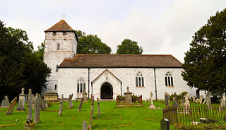
St Cynog's Church is an active parish church in the village of Defynnog, Powys, Wales. The dedication is to Saint Cynog, one of the 24 children of Brychan, a legendary 5th-century king of Brycheiniog. Dating from the 15th century, with earlier elements, the church was restored in the late 19th century. The churchyard is notable for its collection of ancient yew trees, the Defynnog Yew which is among the oldest in Britain. St Cynog's is designated by Cadw as a Grade I listed building.

St Mary Magdalene's Church is an active parish church in the village of Bleddfa, Powys, Wales. Tradition asserts that a clas church was founded on the site by St Brendan the Navigator in the 6th century but there is neither documentary or built evidence to support the claim. The present church dates from the 13th century. The bellcote was built in 1711 and the church restored in the early 20th century and again in the 1970s. St Mary Magdalene's is designated by Cadw as a Grade I listed building.

St Mary's Church is an active parish church in the village of Gladestry, Powys, Wales. The village lies east of Builth Wells close to the border with England. The church is designated by Cadw as a Grade I listed building.

St David's Church is an active parish church in the village of Glascwm, Powys, Wales. It stands in a circular churchyard in the centre of the village, some 9m to the north-east of Builth Wells. It is traditionally associated with Saint David and there was likely an early clas settlement on the site. The church was restored by Ewan Christian in 1891. St David's is designated by Cadw as a Grade I listed building.

