Related Research Articles
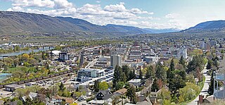
Kamloops is a city in south-central British Columbia, Canada, at the confluence of the two branches of the Thompson River and east of Kamloops Lake. It is located in the Thompson-Nicola Regional District, whose district offices are based here. The surrounding region is more commonly referred to as the Thompson Country.

The Okanagan, also known as the Okanagan Valley and sometimes as the Okanagan Country, is a region in the Canadian province of British Columbia defined by the basin of Okanagan Lake and the Canadian portion of the Okanagan River. It is part of the Okanagan Country, extending into the United States as Okanogan County in north-central Washington. According to the 2016 Canadian census, the region's population is 362,258. The largest populated cities are Kelowna, Penticton, Vernon, and West Kelowna.
Highway 5 is a 543 km (337 mi) north–south route in southern British Columbia, Canada. Highway 5 connects the southern Trans-Canada route with the northern Trans-Canada/Yellowhead route, providing the shortest land connection between Vancouver and Edmonton. Despite the entire route being signed as part of the Yellowhead Highway, the portion of Highway 5 south of Kamloops is also known as the Coquihalla Highway while the northern portion is known as the Southern Yellowhead Highway. The Coquihalla section was a toll road until 2008.

Castlegar is the second-largest community in the West Kootenay region of British Columbia, Canada. In the Selkirk Mountains, at the confluence of the Kootenay and Columbia Rivers, it is a regional trade and transportation centre, with a local economy based on forestry, mining and tourism.

Yaletown is an area of Downtown Vancouver, Canada, bordered by False Creek and Robson and Homer Streets. Formerly a heavy industrial area dominated by warehouses and rail yards, since the 1986 World's Fair it has been transformed into one of the most densely populated neighbourhoods in the city.
Tk’emlúps te Secwépemc, abbreviated TteS and previously known as the Kamloops Indian Band, is a First Nations government within the Shuswap Nation Tribal Council, which represents ten of the seventeen Secwepemc band governments, all in the southern Central Interior region, spanning the Thompson and Shuswap districts. It is one of the largest of the 17 groups into which the Secwepemc (Shuswap) nation was divided when the Colony of British Columbia established an Indian reserve system in the 1860s.
Juniper Ridge is a community located in the city of Kamloops, British Columbia. It is situated at the south-east end of the city on a hillside south of the South Thompson River. There is a convenience store at the entrance to the community, and the area is serviced by an elementary school. It is accessible only by one road, Highland Rd.: however, a formerly washed out dirt road has been refilled allowing emergency access to the Rose Hill area. Most of the streets in this neighbourhood are named after rivers in the province, such as: Skeena, Nechako, Omineca, Babine, Coldwater, etc. Tennis courts, an ice rink with bright lighting, and a dog park are located at the local community centre, Juniper Park.
Brocklehurst is a neighbourhood in the western area of Kamloops, British Columbia, Canada. Brocklehurst is bordered by the Thompson River to the south, North Shore to the east, the Kamloops Airport to the west, and the Batchelor hills and Batchelor Heights aka Batchelor Hills to the north. The community is named after Ed Brocklehurst, a local orchardist from England who lived in the area between 1896 and 1907.
Sahali is a neighbourhood in South Kamloops, British Columbia, Canada, bordered by the Aberdeen and Downtown districts. It is home to most of Kamloops' major grocery and big box stores. It is also site of one of British Columbia's newest universities: Thompson Rivers University. The neighbourhood is the largest in Kamloops and consists of an Upper and Lower Sahali, with an estimated total population of about 12,000 in 2003.
The West End is a South Shore neighbourhood of Kamloops, British Columbia in Canada. It is the city's oldest residential neighbourhood and has the largest proportion of heritage-designated homes.
Rayleigh is a neighbourhood of Kamloops, British Columbia, Canada along Highway 5. It is located on the east side of the North Thompson River and south of the community of Heffley Creek.
Batchelor Heights is a neighbourhood of the city of Kamloops, British Columbia, Canada. Its name derives from that of Batchelor Hill, a local landmark named for Owen Salisbury Batchelor, an early settler, prospector and rancher who lived in the area.
Batchelor Hill 733 m (2405 ft) prominence: 128 m, is a hill overlooking the city of Kamloops, British Columbia, Canada, immediately northwest of the city and north of the neighbourhood of Brocklehurst. It is the namesake of the Batchelor Hills aka Batchelor Heights neighbourhood and also of the small Batchelor Range, which runs north from it on the side of the Kamloops Plateau but does not include it.
Dallas is a neighbourhood of the City of Kamloops, British Columbia, Canada. It has an urban area separated from the Kamloops population centre, with a population of 4,445 as of the Canada 2011 Census.
Dufferin is a neighbourhood of the City of Kamloops, British Columbia, Canada. Originally its own municipality, created in 1971, it was amalgamated with the City of Kamloops in 1973.
Knutsford is a neighbourhood of the City of Kamloops, British Columbia, Canada, located on the south side of that city just west of Peterson Creek. It is named for Knutsford, Cheshire, by Robert Longridge, who took up ranching in the area in 1912.

North Kamloops is a neighbourhood and former town located in the City of Kamloops, British Columbia, Canada. It is located immediately to the northwest of Downtown Kamloops across the confluence of the North and South Thompson Rivers. In 2016, North Kamloops had a population of 10,995, or 12.2% of Kamloops' total population of 90,280, and had the highest population density of any neighbourhood in the city at 2,750 people per km2. North Kamloops is one of four neighbourhoods the City of Kamloops considers part of its Core, the others being Downtown, Sagebrush, and the West End - all on the south shore of the city.
Tranquille is a neighbourhood of the City of Kamloops, British Columbia, Canada, located on the northeast side of Kamloops Lake. It is the site of the Tranquille Sanatorium, a home for the mentally handicapped, a tuberculosis sanatorium, and originally the Kamloops Home for Men. It gets its name from that of the Tranquille River, which enters Kamloops Lake in this area, and so indirectly is named for Chief Tranquille, or Pacamoose, who was the leader of the Secwepemc people in this region in the early 19th Century.

Fern Ridge is a neighbourhood of Langley, British Columbia. It is located in the southwestern area of Langley Township, near Campbell Valley Regional Park. 200th Street, or Carvolth Road, runs south through Fern Ridge, and TransLink provides hourly bus service during daylight hours to Langley City. There is one church in the community, a Mennonite church.

Hatzic is a historic community in the Central Fraser Valley region of the Lower Mainland of British Columbia, Canada, located on the east side of the District of Mission and including areas beyond the municipal boundary to the east and northeast.
References
- ↑ Akrigg, Helen B.; V., G.P. (1997). British Columbia Place Names. Vancouver: UBC Press. p. 1. ISBN 0-7748-0637-0.
- ↑ "Community Associations". City of Kamloops. 2017-02-03. Retrieved 2018-03-26.
Coordinates: 50°39′00″N120°22′00″W / 50.65000°N 120.36667°W
| | This article about a location in the Thompson-Nicola Regional District, Canada is a stub. You can help Wikipedia by expanding it. |