Abim, Uganda

Last updated

Abim
Uganda location map.svg
Red pog.svg
Abim
Map of Uganda showing the location of Abim
Coordinates: 02°42′07″N33°39′36″E / 2.70194°N 33.66000°E / 2.70194; 33.66000
Country Uganda
Region Northern Uganda
Sub-region Karamoja sub-region
District Abim District
Elevation
1,154 m (3,786 ft)
Population
 (2020 Estimate)
  Total24,400 [1]
Time zone UTC+3 (EAT)

Abim is a town in the Northern Region of Uganda. It is the chief municipal, administrative, and commercial center of Abim District. The district is named after the town. [2]

Contents


Location

Abim is located in Abim District, Karamoja sub-region, Northern Region, Uganda. It is located approximately 140 kilometres (87 mi), by road, west of the city of Moroto, the largest urban centre the Karamoja sub-region. [3] This location lies approximately 180 kilometres (112 mi), by road, east of Gulu, the largest city in the Northern Region of Uganda. [4] Abim is located approximately 414 kilometres (257 mi) northeast of Kampala, Uganda's capital and largest city. [5] The geographical coordinates of the town are:2°42'07.2"N 33°39'36.0"E (Latitude:2.7020; Longitude:33.6600). [6]

Population

The 2002 national census enumerated the population of the town at 7,645. In 2014, the national population census and household survey enumerated 17,168 people. [7] In 2015, the Uganda Bureau of Statistics (UBOS) estimated the town's mid-year population at about 18,100. In 2020, UBOS estimated the population of Abim Town Council at 24,400. UBOS calculated that the population of Abim, Uganda increased at an average annual rate of 6.2 percent, between 2015 and 2020. [1]

Points of interest

The following points of interest lie within the town limits or close to the edges of town: [6] (a) the offices of Abim Town Council (b) the headquarters of Abim District Administration (c) Abim Central Market, the source of daily fresh produce (d) Abim General Hospital, a 100-bed public hospital administered by the Uganda Ministry of Health (e) a branch of DFCU Bank (f) a branch of Stanbic Bank Uganda and (g) Soroti–Amuria–Abim–Kotido Road, which passes through town in a general south to north direction. [8]

See also

Related Research Articles

<span class="mw-page-title-main">Kotido District</span> District in Northern Uganda, Uganda

Kotido District is a district in Northern Uganda. It is named after its 'chief town', Kotido, where the district headquarters are located.

<span class="mw-page-title-main">Moroto District</span> District in Northern Region of Uganda, Uganda

Moroto District is a district in the Northern Region of Uganda. The town of Moroto is the site of the district headquarters.

<span class="mw-page-title-main">Lira, Uganda</span> Place in Northern Region of Uganda, Uganda

Lira is a city in the Northern Region of Uganda. It is the main municipal, administrative, and commercial centre of Lira District.

<span class="mw-page-title-main">Soroti</span> Ugandan town

Soroti is a city in Eastern Region of Uganda. It is the main city, commercial, and administrative center in Soroti District, one of the nine administrative districts in the Teso sub-region. Soroti city was immediately approved for operationalization ahead of schedule by the Parliament of Uganda in the Financial Year 2020/2021.

<span class="mw-page-title-main">Moroto Town</span> Place in Northern Region, Uganda

Moroto is a town in Moroto District in the Northern Region of Uganda. The town serves as the location of the district headquarters.

Katakwi is a town in the Eastern Region of Uganda. It is the main municipal, administrative, and commercial center of Katakwi District and the site of the district headquarters.

Kotido is a town in the Northern Region of Uganda. It is the chief municipal, administrative, and commercial center of the Kotido District and the site of the district headquarters.

Nakapiripirit is a town in the Nakapiripirit District of the Northern Region of Uganda. It is the seat of the district headquarters. As an administrative unit of the district, it is one of the eight sub-counties in the district.

Amuria is a town in the Eastern Region of Uganda. It is the chief municipal, administrative, and commercial center of Amuria District, in the Teso sub-region.

<span class="mw-page-title-main">Abim District</span> District in Uganda

Abim District is a district in Northern Uganda. It is named after its 'chief town', Abim, where the district headquarters are located.

<span class="mw-page-title-main">Kaabong</span> Ugandan town

Kaabong is a town in the Northern Region of Uganda. It is the chief municipal, administrative and commercial center of the eponymous Kaabong District, and the district headquarters are located in the town.

Bududa is a town in the Eastern Region of Uganda. It is the main municipal, administrative, and commercial center of Bududa District.

Alebtong, is a town in the Northern Region of Uganda. It is the chief municipal, administrative, and commercial centre of Alebtong District. The district is named after the town.

<span class="mw-page-title-main">Napak District</span> District in Northern Uganda, Uganda

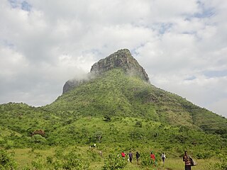
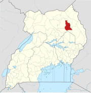
Napak District is a district in Northern Uganda. It is named after Mount Napak, and its headquarters is at Lokitede.

Napak is a town in Northern Uganda. It is the commercial, administrative and municipal headquarters of Napak District. The district is named after the town.

Saint Kizito Hospital Matany, commonly known as Matany Hospital is a private hospital in Matany Trading Centre, Moroto District, Karamoja sub-region, in the Northern Region of Uganda.

Amuru is a town in the Northern Region of Uganda. It is the main municipal, administrative, and commercial centre of Amuru District.

Soroti–Katakwi–Moroto–Lokitanyala Road is a road in the Eastern and Northern regions of Uganda. The road connects the urban centers of Soroti, the largest city in Teso sub-region, to Katakwi, the district headquarters of Katakwi District and to Moroto, the largest city in the Karamoja sub-region. It ends at Lokitanyala, at the international border with Kenya.

Soroti–Amuria–Abim–Kotido Road is a road in the Eastern and Northern Regions of Uganda. The road connects the towns of Soroti in Soroti District, to Amuria in Amuria District, Abim in Abim District, and Kotido, in Kotido District. Soroti and Amuria lie in the Teso sub-region, while Abim and Kotido are in the Karamoja sub-region.

References

  1. 1 2 Uganda Bureau of Statistics (25 July 2021). "The population development of Abim as well as related information and services" (Citypopulaton.de Quoting Uganda Bureau of Statistics). Citypopulation.de. Retrieved 25 July 2021.
  2. Mindat (25 July 2021). "Abim Town Council, Labwor County, Abim District, Northern Region, Uganda". Mindat.org. Retrieved 25 July 2021.
  3. Google (1 January 2021). "Road Distance Between Abim, Uganda And Moroto, Uganda" (Map). Google Maps . Google. Retrieved 1 January 2021.
  4. Google (1 January 2021). "Road Distance Between Abim, Uganda And Gulu, Uganda" (Map). Google Maps . Google. Retrieved 1 January 2021.
  5. Google (25 July 2021). "Road Distance Between Abim, Uganda And Kampala, Uganda With Interactive Map" (Map). Google Maps . Google. Retrieved 25 July 2021.
  6. 1 2 Google (25 July 2021). "Location of Abim Town Council, Labwor County, Abim District, Northern Region, Uganda" (Map). Google Maps . Google. Retrieved 25 July 2021.
  7. Uganda Bureau of Statistics (14 June 2020). "The population of all Ugandan cities and towns with more than 15,000 inhabitants according to census results and latest official projections". Cityppulaion.de Quoting Uganda Bureau of Statistics . Retrieved 25 July 2021.
  8. Google (25 July 2021). "Map Showing Soroti–Amuria–Abim–Kotido Road Going Through Downtown Abim Town Council" (Map). Google Maps . Google. Retrieved 25 July 2021.