Moroto Town

Last updated
Moroto
Moroto Town - seen from Mount Moroto.jpg
Moroto Town - seen from Mount Moroto
Uganda location map.svg
Red pog.svg
Moroto
Location in Uganda
Coordinates: 02°31′48″N34°40′12″E / 2.53000°N 34.67000°E / 2.53000; 34.67000
Country Flag of Uganda.svg Uganda
Region Northern Region
Sub-region Karamoja sub-region
District Moroto District
Elevation
4,490 ft (1,370 m)
Population
 (2020 Estimate)
  Total16,300 [1]

Moroto is a town in Moroto District in the Northern Region of Uganda. The town serves as the location of the district headquarters. [2]

Contents

Location

Moroto is approximately 316 kilometres (196 mi), by road, east of Gulu, the largest city in the Northern Region of Uganda. [3] This is about 271 kilometres (168 mi), by road, northeast of Mbale, the largest city in the Eastern Region of Uganda. [4]

Moroto is located approximately 528 kilometres (328 mi), by road, northeast of Kampala, the capital and largest city of Uganda. [5] The geographical coordinates of Moroto Town are 2°31'48.0"N, 34°40'12.0"E (Latitude:2.5300; Longitude:34.6700). [6] Moroto sits at an average elevation of 1,370 metres (4,490 ft) above mean sea level. [7]

Population

The 2002 national census estimated the population of Moroto at 7,380. In 2010, the Uganda Bureau of Statistics (UBOS) estimated the population at 11,600. In 2011, UBOS estimated the mid-year population at 12,300. [8]

In 2014, the national population census put the population of Moroto at 14,196. In 2020, UBOS estimated the mid-year population of the town at 16,300 people. The population agency calculated that the population of Moroto Town grew at an average annual rate of 2.39 percent between 2014 and 2020. [1]

Historical population
YearPop.±%
20027,380    
201011,600+57.2%
201112,300+6.0%
201414,196+15.4%
202016,300+14.8%
source: [1] [8]

Transport

From the Moroto bus station, there are direct bus services to Kampala, Soroti, Mbale, Nakapiripirit, and other places in Uganda. The main road to Moroto is the Soroti-Moroto Road, which, as of January 2020, is fully paved. The Moroto–Nakapiripirit Road is fully paved as well. [9] The town is also served by Moroto Airport, a public airport located about 8 kilometres (5 mi) west of downtown. [10]

Moroto Post Office, with Mount Moroto in the background Moroto Post Office.jpg
Moroto Post Office, with Mount Moroto in the background

Points of interest

The additional points of interest lie within the town limits or near the edges of town: (1) the offices of Moroto Town Council (2) Mount Moroto, rising to an elevation of 3,083 metres (10,115 ft) about 3 kilometres (1.9 mi) east of town (3) Moroto central market (4) a branch of the National Social Security Fund (5) Moroto Regional Referral Hospital, a 200-bed regional referral hospital administered by the Uganda Ministry of Health (6) a branch of Centenary Bank and (7) a branch of Stanbic Bank Uganda Limited. (8) the headquarters of the Roman Catholic Diocese of Moroto, headed by Bishop Damiano Giulio Guzzetti. [11]

See also

Related Research Articles

<span class="mw-page-title-main">Moroto District</span> District in Northern Region of Uganda, Uganda

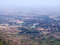
Moroto District is a district in the Northern Region of Uganda. The town of Moroto is the site of the district headquarters.

<span class="mw-page-title-main">Lira, Uganda</span> Place in Northern Region of Uganda, Uganda

Lira is a city in the Northern Region of Uganda. It is the main municipal, administrative, and commercial centre of Lira District.

<span class="mw-page-title-main">Soroti</span> Ugandan town

Soroti is a city in Eastern Region of Uganda. It is the main city, commercial, and administrative center in Soroti District, one of the nine administrative districts in the Teso sub-region. Soroti city was immediately approved for operationalization ahead of schedule by the Parliament of Uganda in the Financial Year 2020/2021.

<span class="mw-page-title-main">Tororo</span> Place in Eastern Region of Uganda, Uganda

Tororo is a town in the Eastern Region of Uganda. It is the main municipal, administrative, and commercial center of Tororo District.

Katakwi is a town in the Eastern Region of Uganda. It is the main municipal, administrative, and commercial center of Katakwi District and the site of the district headquarters.

Kotido is a town in the Northern Region of Uganda. It is the chief municipal, administrative, and commercial center of the Kotido District and the site of the district headquarters.

Nakapiripirit is a town in the Nakapiripirit District of the Northern Region of Uganda. It is the seat of the district headquarters. As an administrative unit of the district, it is one of the eight sub-counties in the district.

Amuria is a town in the Eastern Region of Uganda. It is the chief municipal, administrative, and commercial center of Amuria District, in the Teso sub-region.

Butaleja is a town in Eastern Region of Uganda. It is the main municipal, administrative and commercial center of Butaleja District and the district headquarters are located there. The district is named after the town.

Kumi Town, commonly called Kumi, is a town in the Eastern Region of Uganda. It is the main municipal, administrative, and commercial center in Kumi District and is the site of the district headquarters.

Bukedea is a town in the Eastern Region of Uganda. It is the chief municipal, administrative, and commercial center of Bukedea District, and the district headquarters are located there.

Abim is a town in the Northern Region of Uganda. It is the chief municipal, administrative, and commercial center of Abim District. The district is named after the town.

<span class="mw-page-title-main">Kaabong</span> Ugandan town

Kaabong is a town in the Northern Region of Uganda. It is the chief municipal, administrative and commercial center of the eponymous Kaabong District, and the district headquarters are located in the town.

Bududa is a town in the Eastern Region of Uganda. It is the main municipal, administrative, and commercial center of Bududa District.

Moroto Regional Referral Hospital, commonly known as Moroto Hospital is a hospital in the town of Moroto, in Northeastern Uganda. It is the referral hospital for the districts of Abim, Kaabong, Kotido, Moroto and Nakapiripirit and Napak.

Ngora is a town in the Eastern Region of Uganda. It is the main political, administrative, and commercial centre of Ngora District.

Alebtong, is a town in the Northern Region of Uganda. It is the chief municipal, administrative, and commercial centre of Alebtong District. The district is named after the town.

<span class="mw-page-title-main">Napak District</span> District in Northern Uganda, Uganda

Napak District is a district in Northern Uganda. It is named after Mount Napak, and its headquarters is at Lokitede.

Napak is a town in Northern Uganda. It is the commercial, administrative and municipal headquarters of Napak District. The district is named after the town.

Muyembe is a town in the Eastern Region of Uganda.

References

  1. 1 2 3 Uganda Bureau of Statistics (14 June 2020). "The population of all Ugandan cities and towns with more than 15,000 inhabitants according to census results and latest official projections" (Citypopulation.de Quoting Uganda Bureau of Statistics). Citypopulation.de. Retrieved 28 January 2021.
  2. Ssemutooke, Joseph (7 October 2017). "It's not all gloom in Karamoja". Daily Monitor . Kampala. Retrieved 9 August 2017.
  3. Google (28 January 2021). "Road Distance Between Gulu, Uganda And Moroto, Uganda" (Map). Google Maps . Google. Retrieved 28 January 2021.
  4. Google (28 January 2021). "Map Showing Mbale, Uganda And Moroto, Uganda With Route Marker" (Map). Google Maps . Google. Retrieved 28 January 2021.
  5. Google (28 January 2021). "Road Distance Between Kampala, Uganda And Moroto, Uganda With Interactive Map" (Map). Google Maps . Google. Retrieved 28 January 2021.
  6. Google (28 January 2021). "Location of Moroto Town, Northern Region, Uganda" (Map). Google Maps . Google. Retrieved 28 January 2021.
  7. The Editors of Encyclopaedia Britannica (28 January 2021). "Profile of Moroto, Uganda". Chicago, Illinois, United States: Encyclopaedia Britannica . Retrieved 8 January 2021.
  8. 1 2 Uganda Bureau of Statistics (June 2011). "Projected Population of Moroto Town In 2002, 2010 And 2011" (PDF). Uganda Bureau of Statistics . Kampala, Uganda. Archived from the original (Archived from the original on 7 July 2014) on 7 July 2014. Retrieved 31 July 2022.
  9. Daily Monitor (17 January 2020). "New Moroto-Soroti road boosts trade". Daily Monitor . Kampala. Retrieved 28 January 2021.
  10. Google (28 January 2021). "Road Distance Between Moroto, Uganda And Moroto Airport, Uganda" (Map). Google Maps . Google. Retrieved 28 January 2021.
  11. Steven Ariong and Esther Oluka (27 May 2014). "Moroto Diocese gets new bishop". Daily Monitor . Kampala. Retrieved 21 July 2015.