Moroto District

Last updated
Moroto District
Moroto District in Uganda.svg
District location in Uganda
Coordinates: 02°32′N34°40′E / 2.533°N 34.667°E / 2.533; 34.667
CountryFlag of Uganda.svg  Uganda
Region Northern Region of Uganda
Sub-region Karamoja sub-region
Capital Moroto
Area
  Total3,537.6 km2 (1,365.9 sq mi)
Population
 (2014 census)
  Total103,432 [1]
Time zone UTC+3 (EAT)
Website www.moroto.go.ug

Moroto District is a district in the Northern Region of Uganda. The town of Moroto is the site of the district headquarters. [2]

Contents

Location

Moroto District is bordered by Kaabong District to the north, Kenya to the east, Amudat District to the south, Nakapiripirit District to the southwest, Napak District to the west, and Kotido District to the northwest. Moroto Town, where the district headquarters, is at the foot of Mt. Moroto. [3] The town of Moroto is 213 kilometres (132 mi), by road, northeast of Mbale, the nearest large city. [4] It lies about 434 kilometres (270 mi) northeast of Kampala, the capital and largest city of Uganda. [5]

Overview

Moroto District is part of the larger Karamoja sub-region. Moroto District is "characterized by rocky mountainous landscape with moderately low rainfall". [6]

It is composed of three counties: Bokora County, Matheniko County, and Moroto Municipality. It is inhabited by the Karimojong, a distinctive ethnic group that highly cherishes its traditions. [7]

The district is a hub of mineral resources that are yet to be optimally exploited. There are over fifty different minerals and precious stones in the Karamoja region. Of these, Moroto has gold, silver, copper, iron, titanium, manganese, niobium, tantalite, and chrome. Other proven minerals include marble, mica, garnets, limestone, and asbestos. [8] [9]

Population

In 1991, the national census enumerated the district population at 59,149. The 2002 national census enumerated the population at 77,243. In August 2014, the national census and household survey enumerated the population at 103,432. [1]

Related Research Articles

<span class="mw-page-title-main">Kotido District</span> District in Northern Uganda, Uganda

Kotido District is a district in Northern Uganda. It is named after its 'chief town', Kotido, where the district headquarters are located.

<span class="mw-page-title-main">Nakapiripirit District</span> District in Northern Uganda, Uganda

Nakapiripirit District is a district in Northern Uganda. Like many Ugandan districts, it is named after its 'chief town', Nakapiripirit, where the district headquarters are located.

<span class="mw-page-title-main">Kapchorwa District</span> District in Eastern Uganda, Uganda

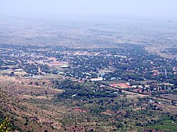
Kapchorwa District is a district in the Eastern Region of Uganda. The town of Kapchorwa is the district's main municipal, administrative, and commercial center, and is the site of the district headquarters. It is also the home district of Stephen Kiprotich, the men's marathon gold medalist at the 2012 Summer Olympics, and Joshua Cheptegei, the men's 5,000 m gold medalist at the 2021 Summer Olympics in Tokyo.

<span class="mw-page-title-main">Moroto Town</span> Place in Northern Region, Uganda

Moroto is a town in Moroto District in the Northern Region of Uganda. The town serves as the location of the district headquarters.

Kotido is a town in the Northern Region of Uganda. It is the chief municipal, administrative, and commercial center of the Kotido District and the site of the district headquarters.

Nakapiripirit is a town in the Nakapiripirit District of the Northern Region of Uganda. It is the seat of the district headquarters. As an administrative unit of the district, it is one of the eight sub-counties in the district.

Kumi Town, commonly called Kumi, is a town in the Eastern Region of Uganda. It is the main municipal, administrative, and commercial center in Kumi District and the site of the district headquarters.

Kyotera is a town in the southern part of the Central Region of Uganda. It is a municipality in Kyotera District. However, the district headquarters are located at Kasaali.

<span class="mw-page-title-main">Abim District</span> District in Uganda

Abim District is a district in Northern Uganda. It is named after its 'chief town', Abim, where the district headquarters are located.

Abim is a town in the Northern Region of Uganda. It is the chief municipal, administrative, and commercial center of Abim District. The district is named after the town.

<span class="mw-page-title-main">Kaabong</span> Ugandan town

Kaabong is a town in the Northern Region of Uganda. It is the chief municipal, administrative and commercial center of the eponymous Kaabong District, and the district headquarters are located in the town.

Ngoma is a small town in Nakaseke District, Central Uganda. It is one of the municipalities within Nakaseke District. Other municipalities in the district include: (a) Butalangu (b) Kapeeka (c) Nakaseke (d) Semuto and (e) Wakyaato.

<span class="mw-page-title-main">Amudat District</span> District in Northern Uganda, Uganda

Amudat District is a district in Northern Uganda. Like most Ugandan districts, it is named after its 'chief town', Amudat, where the district headquarters are located.

<span class="mw-page-title-main">Napak District</span> District in Northern Uganda, Uganda

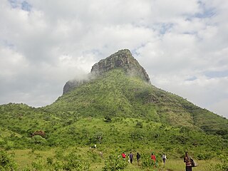
Napak District is a district in Northern Uganda. It is named after Mount Napak, and its headquarters is at Lokitede.

Napak is a town in Northern Uganda. It is the commercial, administrative and municipal headquarters of Napak District. The district is named after the town.

Lwakhakha is a town in the Eastern Region of Uganda. It is one of the municipal centers in Manafwa District. The town lies across the international border from Lwakhakha, Kenya.

Moroto–Nakapiripirit Road is a road in the Northern Region of Uganda. The road connects the towns of Moroto, the largest town in the Karamoja sub-region, and Nakapiripirit in the same sub-region.

Muyembe is a town in the Eastern Region of Uganda.
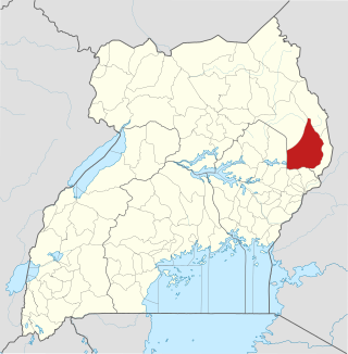
Rubona is a town in the Western Region of Uganda.

Lorengecora is a settlement in the Northern Region of Uganda. It is the headquarters of Lorengecora Parish, in Iriri sub-county, in Bokora County, in Napak District, in the Karamoja sub-region.

References

  1. 1 2 UBOS (November 2014). "The Population of Moroto District In 1991, 2002 and 2014". Citypopulation.de Quoting Uganda Bureau of Statistics (UBOS). Retrieved 9 August 2017.
  2. Ariko, Charles (9 August 2006). "Moroto District to get power, says Migereko". New Vision . Kampala. Retrieved 9 August 2017.
  3. Google (9 August 2017). "Map of Moroto District Showing Mount Moroto and Moroto Town" (Map). Google Maps . Google. Retrieved 9 August 2017.
  4. GFC (9 August 2017). "Distance between Mbale, Eastern Region, Uganda and Moroto, Northern Region, Uganda". Globefeed.com (GFC). Retrieved 9 August 2017.
  5. GFC (9 August 2017). "Distance between Post Office Building, Kampala Road, Kampala, Uganda and Moroto, Northern Region, Uganda". Globefeed.com (GFC). Retrieved 9 August 2017.
  6. Sarah A. Nalule (August 2010). "Social Management of Rangelands and Settlement in Karamoja: Moroto and Napak Districts" (PDF). Rome: Food and Agriculture Organization . Retrieved 9 August 2017.
  7. Ssemutooke, Joseph (7 October 2017). "It's not all gloom in Karamoja". Daily Monitor . Kampala. Retrieved 9 August 2017.
  8. Mwesigwa, Alon (4 February 2014). "Mineral Deposits In Uganda's Karamoja Heighten Human Rights Abuse – Report". The Guardian . Retrieved 23 May 2014.
  9. Ariong, Steven (5 April 2014). "Karamoja Miners Demand Mineral Weighbridges" . Retrieved 23 May 2014.