Rubirizi District

Last updated

Rubirizi District
Rubirizi District in Uganda.svg
District location in Uganda
Coordinates: 00°16′S30°06′E / 0.267°S 30.100°E / -0.267; 30.100
CountryFlag of Uganda.svg  Uganda
Region Western Uganda
Sub-region Ankole sub-region
Capital Rubirizi
Area
  Land985 km2 (380 sq mi)
Elevation
1,764 m (5,787 ft)
Population
 (2014 Census)
  Total129,149
  Density143.6/km2 (372/sq mi)
Time zone UTC+3 (EAT)
Area code 112
Website www.rubirizi.go.ug

Rubirizi District is a district in Western Uganda. Like most Ugandan districts, the district is named after its 'chief town', Rubirizi, where the district headquarters are located. [1]

Contents

Location

Rubirizi District is bordered by Kasese District to the north, Kitagwenda District to the northeast, Ibanda District to the east, Buhweju District to the southeast, Bushenyi District to the south, Rukungiri District to the southwest and the Democratic Republic of the Congo to the west. The district headquarters at Rubirizi are located approximately 97 kilometres (60 mi), by road, northwest of Mbarara, the largest city in Ankole sub-region. [2] This is approximately 364 kilometres (226 mi), southwest of Kampala, Uganda's capital and largest city. [3] The coordinates of the district are: 00 16S, 30 06E. [4]

Overview

Twin crater lakes, Kyema and Kamweru, in Rubirizi District Twin crater lakes Kyema and Kamweru.jpg
Twin crater lakes, Kyema and Kamweru, in Rubirizi District

Rubirizi District was carved out of Bushenyi District in July 2010. Prior to then, the district was known as Bunyaruguru County. [5]

It is one of the districts that constitute Ankole sub-region, home to an estimated 3.9 million Banyankole, in 2018, according to CIA Factbook. The full list of districts in the sub-region include: 1. Buhweju District 2. Bushenyi District 3. Ibanda District 4. Isingiro District 5. Kiruhura District 6. Mitooma District 7. Ntungamo District 8. Rubirizi District 9. Sheema District

About 50% of Queen Elizabeth National Park lies in Rubirizi District. The key tourist areas of the park found in the district include:

Population

In 1991, the national population census estimated the district population at about 75,400. The national census in 2002 estimated the population in the district at about 101,800. The Rubirizi District population was enumerated at 129,149 in 2014. [7] In 2020, the mid-year population of the district was projected at 144,100 people. The annual rate of population growth in the district was calculated to average 1.9 percent, between 2014 and 2020. [8]

Historical population
YearPop.±%
199175,400    
2002101,800+35.0%
2014129,149+26.9%
2020144,100+11.6%
source: [7] [8]

See also

Related Research Articles

<span class="mw-page-title-main">Mbarara district</span> District in Western Uganda, Uganda

Mbarara District is a district in South Western Uganda. In 2019, the Ugandan Cabinet approved part of Mbarara District, the then-Mbarara municipality, to be upgraded to city status effective July 2020.

<span class="mw-page-title-main">Bushenyi District</span> District in Western Uganda, Uganda

Bushenyi District is a district in Western Uganda. Like many other Ugandan districts, it is named after its chief town, Bushenyi, where the district headquarters are located.

Mbarara University of Science & Technology (MUST), commonly known as Mbarara University, is a public university in Uganda. Mbarara University commenced student intake and instruction in 1989. It is one of the ten public universities and degree-awarding institutions in the country. MUST is accredited by the Uganda National Council for Higher Education.

<span class="mw-page-title-main">Mbarara</span> Place in Western Region, Uganda

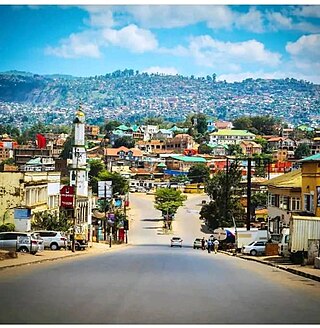
Mbarara City is a city in the Western Region of Uganda and the second largest city in Uganda after Kampala. The city is divided into 6 boroughs of Kakoba Division, Kamukuzi Division, Nyamitanga Division, Biharwe Division, Kakiika Division, Nyakayojo Division. It is the main commercial centre of most of south western districts of Uganda and the site of the district headquarters. In May 2019, the Uganda's cabinet granted Mbarara a city status, which started on 1 July 2020.

<span class="mw-page-title-main">Bushenyi</span> Place in Western Uganda, Uganda

Bushenyi is a town in Western Uganda. It is the 'chief town' of Bushenyi District and the district headquarters are located there. The district is named after the town, in keeping with the practice in most of the districts in the country.

<span class="mw-page-title-main">Ibanda District</span> District in Western Region, Uganda

Ibanda District is a district in the Western Region of Uganda. The town of Ibanda is the site of the district headquarters.

<span class="mw-page-title-main">Kiruhura District</span> District in Western Region, Uganda

Kiruhura District is a district in the Western Region of Uganda. The town of Rushere is the site of the district headquarters.

Ibanda is a town in the Western Region of Uganda. It is the main political, administrative, and commercial centre of Ibanda District and the site of the district headquarters. It started wayback in 1990s and was elevated from a trading centre to a town board, town council and in 2016 it was granted a Municipality status. The Municipal Council has three Divisions of Kagongo, Bisheshe and Bufunda with 21 wards of Kyaruhanga, Bufunda, Nyamirima, Nsasi, Kayenje, Kashangura, Rwenshuri, Kigarama, Rugazi, Rwobuzizi, Kakatsi, Bugarama, Karangara, Kabaare, Kanyansheko, Nyakatookye, Kyeikucu, Kikoni, Kagongo, Ruyonza and Katongore ward. Ibanda Municipal Council has over 230 villages. Ibanda Municipal council commenced its operations on 1 July 2016 after being elevated from a Town Council and other sub counties that were annexed to..

Mbarara Regional Referral Hospital, commonly known as Mbarara Hospital, is a hospital in Mbarara in the Western Region of Uganda. It is the referral hospital for the region and specifically for the districts of Mbarara, Bushenyi, Ntungamo, Kiruhura, Ibanda, and Isingiro. The hospital serves as the teaching hospital for the Mbarara University of Science and Technology.

Isingiro is a town in the Western Region of Uganda. It is the main municipal, administrative, and commercial center of Isingiro District and the site of the district's headquarters.

Ankole sub-region is a region in the Western Region of Uganda that consists of the following districts:

<span class="mw-page-title-main">Rubirizi</span> Ugandan town

Rubirizi, sometimes spelled Rubiriizi, is a town in Rubirizi District, Ankole sub-region, Western Uganda. The town is the main municipal, administrative and commercial center of Rubirizi District. The district is named after the town.

<span class="mw-page-title-main">Buhweju District</span> District in Western Uganda, Uganda

Buhweju District is a district in Western Uganda. It is one of the districts that constitute the Ankole sub-region. Its 'chief town', is Nsiika.

<span class="mw-page-title-main">Mitooma District</span> District in Uganda

Mitooma District is a district in Western Uganda. It is named after its main municipal, administrative and commercial center, Mitooma.

Mitooma, also Mitoma, is a town in the Western Region of Uganda. It is the main municipal, administrative, and commercial center of Mitooma District.

<span class="mw-page-title-main">Sheema District</span> District in Western Uganda, Uganda

Sheema District is a district in Western Uganda.

Kibingo is a town in Western Uganda. It is the location of the district headquarters of Sheema District.

Bweranyangi Girls' Secondary School is a girls-only boarding middle and high school in Bushenyi District in the Western Region of Uganda.

Rubindi is a town in Mbarara District, Greater Mbarara region, Ankole sub-region, Western Uganda.

Sanga, is an urban center in the Kiruhura District, Ankole sub-region, in the Western Region of Uganda.

References

  1. Rubirizi District (2019). "Rubirizi District: Overview". Rubirizi District. Retrieved 26 March 2019.
  2. "Road Distance Between Mbarara, Uganda And Rubirizi, Uganda" . Retrieved 24 July 2022.
  3. Google (24 July 2022). "Road Distance Between Kampala, Uganda And Rubirizi, Uganda" (Map). Google Maps . Google. Retrieved 24 July 2022.
  4. Google (26 March 2019). "Location of Rubirizi District, Western Region, Uganda" (Map). Google Maps . Google. Retrieved 26 March 2019.
  5. Newvision Archives/Vision Reporters (22 April 2010). "Government Names 14 New Districts". New Vision . Archived from the original (Archived from he original on 29 October 2013) on 29 October 2013. Retrieved 26 March 2019.
  6. Rubirizi District (4 June 2018). "Rubirizi District Is Nature's Paradise". Rubirizi District. Retrieved 26 March 2019.
  7. 1 2 Citypopulation.de (11 March 2019). "The population development of Rubirizi District". Citypopulation.de. Retrieved 26 March 2019.
  8. 1 2 Citypopulation.de (12 June 2020). "Rubirizi District: Population Projection 2020". Citypopulation.de. Retrieved 24 July 2022.