Ntungamo District

Last updated
Ntungamo District
Kyafola Hot Spring 1.jpg
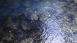
Hot springs in Ntungamo District
Ntungamo District in Uganda.svg
District location in Uganda
Coordinates: 00°53′S30°16′E / 0.883°S 30.267°E / -0.883; 30.267
CountryFlag of Uganda.svg  Uganda
Region Western Uganda
Sub-region Ankole sub-region
Capital Ntungamo
Area
  Total2,051 km2 (792 sq mi)
  Water74.2 km2 (28.6 sq mi)
Population
 (2012 Estimate)
  Total480,100
  Density234/km2 (610/sq mi)
Time zone UTC+3 (EAT)
Area code 034
Website www.ntungamo.go.ug

Ntungamo District is a district in Western Uganda. Like most Ugandan districts, it is named after its 'chief town', Ntungamo, the location of the district headquarters. Ntungamo was elevated to a district on 5th May 1993.

Contents

Overview

In the past, Ntungamo District was part of the Ankole Kingdom, a traditional monarchy that dates back to the 18th century. The kingdom was abolished by Milton Obote in 1967. The current President of Uganda, Yoweri Museveni, and his wife, Janet Museveni, were born in the district. [1] The Ankole Kingdom is coterminous with Ankole sub-region, home to an estimated 2.2 million inhabitants in 2002, according to the national census conducted that year.[ citation needed ]

Location

Hilly green scenery on the Mbarara to Ntungamo road in Western Uganda

Ntungamo District is bordered to the north by Mitooma District, Sheema District and Rwampara District, going from west to east. Isingiro District lies to the east, the Republic of Rwanda to the south, Rukiga District to the southwest and Rukungiri District to the northwest. [2] The district headquarters at Ntungamo, are located about 66 kilometres (41 mi), by road, southwest of Mbarara, the largest city in Ankole sub-region. [3] The general coordinates of the district are: 00 53S, 30 16E. The district covers 2,051.4 square kilometres (792.0 sq mi) of which approximately 0.2% is open water, 3.4% is wetland and about 0.01% is forest.


Population

In 1991, the national population census estimated the district population at about 305,200. The national census of 2002 estimated the population of Ntungamo District at about 380,000, with an estimated annual population growth rate of 2.4%. It is estimated that in 2012, the population of the district was approximately 480,100. [4] Based on the Uganda Bureau of Statistics 2020 population projections, the current population now stands at 540,800. [5]

Tourism in Ntungamo District

Tourism in Ntungamo District is not well developed but there are several potential tourism sites, including: 1. Karegyeya Rock 2. Lake Nyabihoko 3. Uganda-Rwanda Border 4. Bird-watching in the wetlands and 5. Agricultural development projects. 6.Kyafola Hot Springs.

Notable people

See also

Related Research Articles

<span class="mw-page-title-main">Mbarara district</span> District in Western Uganda, Uganda

Mbarara District is a district in South Western Uganda. In 2019, the Ugandan Cabinet approved part of Mbarara District, the then-Mbarara municipality, to be upgraded to city status effective July 2020.

<span class="mw-page-title-main">Bushenyi District</span> District in Western Uganda, Uganda

Bushenyi District is a district in Western Uganda. Like many other Ugandan districts, it is named after its chief town, Bushenyi, where the district headquarters are located.

<span class="mw-page-title-main">Mbarara</span> Place in Western Region, Uganda

Mbarara City is a city in the Western Region of Uganda and the second largest city in Uganda after Kampala. The city is divided into 6 boroughs of Kakoba Division, Kamukuzi Division, Nyamitanga Division, Biharwe Division, Kakiika Division, Nyakayojo Division. It is the main commercial centre of most of south western districts of Uganda and the site of the district headquarters. In May 2019, the Uganda's cabinet granted Mbarara a city status, which started on 1 July 2020.

Rukungiri is a town in Rukungiri District of the Western Region of Uganda. It is the site of the district headquarters.

Ntungamo is a town in the Western Region of Uganda. It is the largest town in Ntungamo District and the site of the district headquarters.

<span class="mw-page-title-main">Isingiro District</span> District in Western Uganda, Uganda

Isingiro District is a district in the Western Region of Uganda. The town of Isingiro is the district's main municipal, administrative, and commercial center.

<span class="mw-page-title-main">Kiruhura District</span> District in Western Region, Uganda

Kiruhura District is a district in the Western Region of Uganda. The town of Rushere is the site of the district headquarters.

Ibanda is a town in the Western Region of Uganda. It is the main political, administrative, and commercial centre of Ibanda District and the site of the district headquarters. It started way back in the 1990s and was elevated from a trading centre to a town board, town council and in 2016 it was granted the municipality status. The Municipal Council has three Divisions of Kagongo, Bisheshe and Bufunda with 21 wards of Kyaruhanga, Bufunda, Nyamirima, Nsasi, Kayenje, Kashangura, Rwenshuri, Kigarama, Rugazi, Rwobuzizi, Kakatsi, Bugarama, Karangara, Kabaare, Kanyansheko, Nyakatookye, Kyeikucu, Kikoni, Kagongo, Ruyonza and Katongore ward. Ibanda Municipal Council has over 230 villages. Ibanda Municipal council commenced its operations on 1 July 2016 after being elevated from a Town Council and other sub counties that were annexed to..

Mbarara Regional Referral Hospital, commonly known as Mbarara Hospital, is a hospital in Mbarara in the Western Region of Uganda. It is the referral hospital for the region and specifically for the districts of Mbarara, Bushenyi, Ntungamo, Kiruhura, Ibanda, and Isingiro. The hospital serves as the teaching hospital for the Mbarara University of Science and Technology.

Isingiro is a town in the Western Region of Uganda. It is the main municipal, administrative, and commercial center of Isingiro District and the site of the district's headquarters.

Kiruhura is a town in the Western Region of Uganda. It is the largest town in Kiruhura District and the site of the district headquarters.

Sheema, also Sheema Municipality, is an urban centre in the Western Region of Uganda. It is the largest municipality in Sheema District.

Ankole sub-region is a region in the Western Region of Uganda that consists of the following districts:

<span class="mw-page-title-main">Rubirizi District</span> District in Western Uganda, Uganda

Rubirizi District is a district in Western Uganda. Like most Ugandan districts, the district is named after its 'chief town', Rubirizi, where the district headquarters are located.

<span class="mw-page-title-main">Buhweju District</span> District in Western Uganda, Uganda

Buhweju District is a district in Western Uganda. It is one of the districts that constitute the Ankole sub-region. Its 'chief town', is Nsiika.

<span class="mw-page-title-main">Mitooma District</span> District in Uganda

Mitooma District is a district in Western Uganda. It is named after its main municipal, administrative and commercial center, Mitooma.

<span class="mw-page-title-main">Sheema District</span> District in Western Uganda, Uganda

Sheema District is a district in Western Uganda.

Itojo Hospital is a hospital in Itojo, Ntungamo District, in Western Uganda.

Bweranyangi Girls' Secondary School is a girls-only boarding middle and high school in Bushenyi District in the Western Region of Uganda.

Sanga, is an urban center in the Kiruhura District, Ankole sub-region, in the Western Region of Uganda.

References

  1. "Biography, President Yoweri Kaguta Museveni". Towering K Museveni. Retrieved 17 August 2018.
  2. Uganda District Map
  3. "Distance Between Mbarara And Ntungamo With Map". Globefeed.com. Retrieved 20 May 2014.
  4. "Estimated Population of Ntungamo District In 1991, 2002 & 2012". Citypopulation.de. Retrieved 20 May 2014.
  5. Uganda Bureau of Statistics (2020). "Uganda Bureau of Statistics: Statistical Abstract" (PDF). Uganda Bureau of Statistics. Retrieved 12 September 2021.
  6. "Ex-army court chairman Brig. Rwehururu dies". Daily Monitor. 27 February 2015. Retrieved 13 November 2022.