Mubende District

Last updated
Mubende District
Mubende District in Uganda.svg
District location in Uganda
Coordinates: 00°36′N31°24′E / 0.600°N 31.400°E / 0.600; 31.400 Coordinates: 00°36′N31°24′E / 0.600°N 31.400°E / 0.600; 31.400
CountryFlag of Uganda.svg  Uganda
Region Central Uganda
Capital Mubende
Area
  Land4,620.2 km2 (1,783.9 sq mi)
Elevation
1,300 m (4,300 ft)
Population
 (2012 Estimate)
  Total610,600
  Density132.2/km2 (342/sq mi)
Time zone UTC+3 (EAT)
Website www.mubende.go.ug

Mubende is a district in the Central Region of Uganda. The town of Mubende is the site of the district headquarters. The district was reduced in size in July 2005 with the creation of the Mityana District and reduced again in 2019 with the creation of Kassanda District.

Contents

Location

Mubende District is bordered by Kyankwanzi District to the north, Kiboga District and Kassanda to the northeast and Mityana District to the east. Gomba District and Sembabule District lie to the south, Kyegegwa District to the southwest and Kibaale District to the northwest of Mubende District. [1] Mubende, the district headquarters, is located approximately 172 kilometres (107 mi), by road, west of Kampala, the capital of Uganda, and the largest city in that country. [2] The coordinates of Mubende District are:00 36N, 31 24E.

Overview

The district covers an area of approximately 4,620 square kilometres (1,780 sq mi). It comprises three counties, namely Buwekula, Kassanda and Kasambya. The district has eighteen sub-counties and one town council which include: [3] Kassanda is no longer among its counties. It has been confirmed to be an independent district. [4]

  1. Bagezza
  2. Bukuya
  3. Butoloogo
  4. Kalwana
  5. Kasambya
  6. Kassanda
  7. Kibalinga
  8. Kiganda
  9. Kigando
  10. Kitenga
  11. Kitumbi
  12. Kiyuni
  13. Madudu
  14. Makokoto
  15. Mannyogaseka
  16. Mubende Town Council
  17. Myanzi
  18. Nabingoola
  19. Naluntuntu

Population

The 1991 population census estimated the district population at about 277,500. In 2002 the national census estimated the population of the district to be about 423,450 people of whom (50.3%) were males and (49.7%) were female, with an annual population growth rate of 3.6%. It is estimated that in 2012, the population of the district was about 610,600. [5] [6]

Economic activity

The major economic activity in Mubende District is agriculture with emphasis on food crops like:

Cash crops grown in the district include:

See also

Related Research Articles

Kayunga District District in Central Uganda, Uganda

Kayunga District is a district in Central Uganda. Like most other Ugandan districts, it is named after its 'chief town', Kayunga.

Kiboga District District in BugandaRegion of Uganda, Uganda

Kiboga District is a district in the Buganda Region of Uganda. The town of Kiboga is the site of the district headquarters.

Wakiso District District in Central Uganda, Uganda

Wakiso District is a district in the Central Region of Uganda that partly encircles Kampala, Uganda's capital city. The town of Wakiso is the site of the district headquarters. Kira, the country's second largest city and suburb of Kampala, is in the district.

Kibaale District District in Western Region, Uganda

Kibaale District, is a district in the Western Region of Uganda. The district headquarters are in the town of Kibaale.

Sembabule is a town in Sembabule District in the Central Region of Uganda. The town is the main municipal, administrative, and commercial center of the district and the site of the district headquarters.

Mubende Place in Central Region of Uganda, Uganda

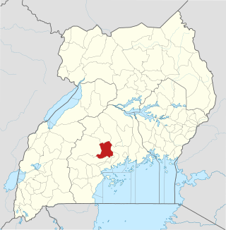
Mubende is a town in the Central Region of Uganda. It is the main municipal, administrative, and commercial center of Mubende District and is the location of the district headquarters.

Mityana District District in Central Region of Uganda, Uganda

The Mityana District is a district in the Central Region of Uganda. The district was created in 2005, by taking the Mityana and Busujju counties from Mubende District. Mityana is the site of the district headquarters.

Mityana Place in Central Uganda, Uganda

Mityana, is a town in the Central Region of Uganda. It is the main municipal, administrative, and commercial center of Mityana District, and the district headquarters are located there.

Abim District District in Uganda

Abim District is a district in Northern Uganda. It is named after its 'chief town', Abim, where the district headquarters are located.

Mubende Regional Referral Hospital, commonly known as Mubende Hospital is a hospital in the town of Mubende, in the Central Region of Uganda. It is the referral hospital for the districts of Mubende, Mityana, Kiboga, and Kyankwanzi.

Butambala District District in Central Region, Uganda

Butambala District is a district in the Central Region of Uganda.

Gomba District District in Central Uganda, Uganda

Gomba is a district in Central Uganda.

Kyankwanzi District District in Buganda Region, Uganda

Kyankwanzi District is the northernmost district in the Buganda Region of Uganda and Buganda Kingdom, bordering Bunyoro. The district headquarters are in Butemba Town.

Ngora District District in Eastern Region of Uganda, Uganda

Ngora District is a district in the Eastern Region of Uganda. The town of Ngora is the site of the district headquarters.

Mityana Hospital, also Mityana General Hospital or Mityana District Hospital is a hospital in the town of Mityana, Mityana District in the Central Region of Uganda.

The Myanzi–Kassanda–Bukuya–Kiboga Road is a road in Uganda, connecting the towns of Myanzi, Kassanda and Bukuya in Mubende District, to Kiboga in Kiboga District.

The Mityana–Mubende Road is a road in the Central Region of Uganda, connecting the towns of Mityana, in Mityana District and Mubende in Mubende District.

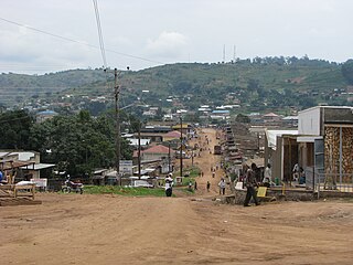
Myanzi is a small town in the Central Region of Uganda.

Kassanda is a town in Kassanda District, in the Buganda area of Uganda.

The Mityana–Kalangaalo–Bukuya–Kiboga Road is a road in Uganda, connecting the towns of Mityana, and Kalangaalo in Mityana District, Bukuya in Mubende District, to Kiboga in Kiboga District.

References

  1. Uganda District Map
  2. "Road Distance Between Kampala And Mubende With Map". Globefeed.com. Retrieved 12 May 2014.
  3. (PDF). Local Government Budget Framework Pape http://budget.go.ug/budget/sites/default/files/Indivisual%20LG%20Budgets/Mubende%20LG_BFP%202017_18.pdf . Retrieved 17 March 2018.{{cite web}}: Missing or empty |title= (help)
  4. "Overview | Kasanda District LG". kasanda.go.ug. Retrieved 2022-03-03.
  5. "Estimated Population of Mubende District In 1991, 2002 & 2012". City Population.de. Retrieved 12 May 2014.
  6. "The Demographics of Mubende District". Kassanda Cornerstone Foundation. Archived from the original on 6 October 2013. Retrieved 12 May 2014.