Masaka District is a district in Buganda Kingdom in Uganda. Its main town is Masaka City, whose estimated population in 2011 was 74,100.
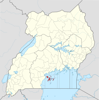
Kalangala, also known as Ssesse, is a district in Central Uganda. The district is coterminous with the Ssese Islands in Lake Victoria and does not have territory on mainland Uganda. Like other Ugandan districts, it is named after its 'chief town', Kalangala which is located on Bugala Island, the largest of the Ssese Islands.To reach Kalangala town on Bugala island one has to board a boat at specified points or use one of the Ferries sailing through the Bukakata-Luku route that joins the town with the mainland in Masaka District. There is also a relatively longer route that passes via Nakiwogo in Wakiso district to connect to Lutoboka on Bugala Island.

Rakai District is a district in the Central Region of Uganda. The town of Rakai is the site of the district's headquarters.

Kamuli District is a district in the Eastern Region of Uganda. The town of Kamuli is the site of the district headquarters.
Pallisa District is a district in Eastern Uganda which was carved out of Tororo district in 1991. Like most other Ugandan districts, it is named after its main town, Pallisa, where the district headquarters are located.

Bushenyi District is a district in Western Uganda. Like many other Ugandan districts, it is named after its chief town, Bushenyi, where the district headquarters are located.

Kasese District is a district in Western Uganda. Like most other Ugandan districts, it is named after its chief town and district headquarters, the town of Kasese.

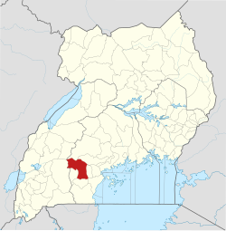
Sembabule is a town in Sembabule District in the Central Region of Uganda. The town is the main municipal, administrative, and commercial center of the district and the site of the district headquarters.

Bukwo District is a district in the Eastern Region of Uganda. The town of Bukwo is its main political, administrative, and commercial center and the site of the district headquarters.

Kiruhura District is a district in the Western Region of Uganda. The town of Rushere is the site of the district headquarters.
Uganda's favorable soil conditions and climate have contributed to the country's agricultural success. Most areas of Uganda have usually received plenty of rain. In some years, small areas of the southeast and southwest have averaged more than 150 millimeters per month. In the north, there is often a short dry season in December and January. Temperatures vary only a few degrees above or below 20 °C but are moderated by differences in altitude.

Lyantonde District is a district in southern Central Uganda. It is named after the 'chief town' of the district, Lyantonde, where the district headquarters are located.
Bukomansimbi is a town in the Central Region of Uganda. It is the chief municipal, administrative, and commercial center of Bukomansimbi District and the site of the district headquarters.

Bukomansimbi District is a district in Central Uganda. The district is named after its main municipal center, Bukomansimbi, the location of the district headquarters.
Maddu is a town in Gomba District in the Central Region of Uganda.
Lwemiyaga County is a county in the Central Region of Uganda.
Mateete is a town in the Central Region of Uganda.
Mawogola County is a county in the Central Region of Uganda.
Ntuusi is a settlement in the Central Region of Uganda.

Kazo is a district in Uganda's Western Region. It is located approximately 200 square kilometres (77 sq mi) west of Uganda's capital Kampala. It covers an area of 1,556 square kilometres (601 sq mi) and recorded a population of 177,054 in the 2014 Ugandan census. The capital of the district is the town of Kazo.