
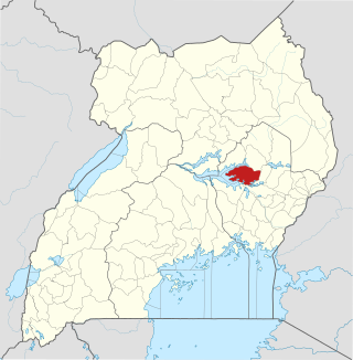
Kaberamaido is a district in Eastern Uganda. Like most other Ugandan districts, it is named after its 'chief town', Kaberamaido, where the district headquarters are located.

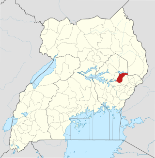
Katakwi District is a district in the Eastern Region of Uganda. The town of Katakwi is the site of the district headquarters.
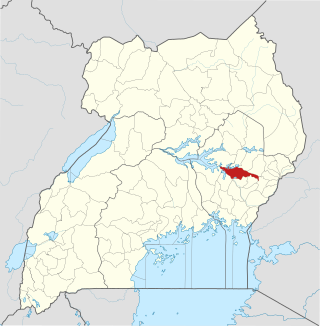
Kumi District is a district in the Eastern Region of Uganda. The district is named after its main town, Kumi, which also hosts the district headquarters.
Pallisa District is a district in Eastern Uganda which was carved out of Tororo district in 1991. Like most other Ugandan districts, it is named after its main town, Pallisa, where the district headquarters are located.
The Kumam people are part of a Hamites ethnic group of about 720,000 census 2024, living mainly Kumam Sub-Region of Kaberamaido, Soroti, Soroti City, Kalaki, parts of Serere, Dokolo and Amolatar respectively in the western areas of Teso sub-region and the south-east of Lango sub-region. The Kumam are an ethnic group of people found in Kaberamaido district, Soroti District|Soroti District, Soroti City| Kalaki District| Kalaki District, Dokolo District| Amolatar District, Lake Kyoga Basin Area, district in Eastern Uganda. They share Soroti district with the Iteso and some parts of formerly Lira district with the Langi. In the Lango region, they are now found in Dokolo district which was detached from Lira District. They are found at the shores of Lake Kyoga (Namasale). In Soroti district, they are found in Serere, Asuret, Kamuda, katine, Soroti city, Arapai as well as the outskirts of Soroti district neighboring Kaberamaido.

The Iteso are a Nilotic ethnic group in eastern Uganda and western Kenya. Teso refers to the traditional homeland of the Iteso, and Ateso is their language.

Soroti is a city in Eastern Region of Uganda. It is the main city, commercial, and administrative center in Soroti District, one of the nine administrative districts in the Teso sub-region. Soroti city was immediately approved for operationalization ahead of schedule by the Parliament of Uganda in the Financial Year 2020/2021.

Teso sub-region is a sub-region in Eastern Region, Uganda that consists of:

Katakwi is a town in the Eastern Region of Uganda. It is the main municipal, administrative, and commercial center of Katakwi District and the site of the district headquarters.

Kaberamaido is a town in Eastern Uganda. It is the main municipal, administrative and commercial center of Kaberamaido District and is the location of the headquarters for the district.

Amuria is a town in the Eastern Region of Uganda. It is the chief municipal, administrative, and commercial center of Amuria District, in the Teso sub-region.

Amuria District is a district in the Eastern Region of Uganda. The town of Amuria serves as the district headquarters.
The Roman Catholic Diocese of Soroti is a diocese located in the city of Soroti in the ecclesiastical province of Tororo in Uganda.
Serere is a town in Eastern Uganda. It is the chief political, administrative and commercial town in Serere District, and the district headquarters are located there. The district is named after the town.
Soroti Regional Referral Hospital, commonly known as Soroti Hospital is a hospital in the city of Soroti, in Soroti District, in Eastern Uganda. It is the referral hospital for the districts of Amuria, Bukedea, Kaberamaido, Kapelebyong, Katakwi, Kumi, Ngora, Serere and Soroti.
Serere District is a district in Eastern Uganda. It is named after its 'chief town', Serere, which serves as the district headquarters.

Ngora District is a district in the Eastern Region of Uganda. The town of Ngora is the site of the district headquarters.
Ngora is a town in the Eastern Region of Uganda. It is the main political, administrative, and commercial centre of Ngora District.
Ngora Freda Carr Hospital, commonly known as Ngora Hospital, is a community hospital in Uganda. It is affiliated with the Anglican Church of Uganda. It was founded in 1922. It has capacity of 180 beds.

