Bukedea District

Last updated
Bukedea District
Bukedea District in Uganda.svg
District location in Uganda
Coordinates: 01°21′N34°03′E / 1.350°N 34.050°E / 1.350; 34.050
CountryFlag of Uganda.svg  Uganda
Region Eastern Region of Uganda
Sub-region Teso sub-region
Capital Bukedea
Area
  Land1,051.7 km2 (406.1 sq mi)
Population
 (2012 Estimate)
  Total186,400
  Density177.2/km2 (459/sq mi)
Time zone UTC+3 (EAT)
Website bukedea.go.ug

Bukedea District is a district in the Eastern Region of Uganda. The town of Bukedea is the site of the district headquarters.

Contents

Location

Bukedea District is bordered by Kumi District to the west and north, Bulambuli District to the east, Sironko District and Mbale District to the south-east, and Pallisa District to the south. The district headquarters at Bukedea are approximately 79 kilometres (49 mi), by road, south-east of Soroti, the largest city in the Teso sub-region. [1]

Overview

Bukedea District was created by an Act of the Ugandan parliament on 13 July 2006 and became operational on 1 July 2007. [2] Before that, the district was part of Kumi District. [3]

Population

The 1991 census estimated the district population at 75,300. The national census in 2002 estimated the population at 122,400. The annual population growth rate in the district was calculated at 4.4 percent. In 2012, the population was estimated at 186,400. [4]

Related Research Articles

<span class="mw-page-title-main">Busia District</span> District in Eastern Region of Uganda, Uganda

Busia District is a district in the Eastern region of Uganda.

<span class="mw-page-title-main">Kaberamaido District</span> District in Eastern Uganda, Uganda

Kaberamaido is a district in Eastern Uganda. Like most other Ugandan districts, it is named after its 'chief town', Kaberamaido, where the district headquarters are located.

<span class="mw-page-title-main">Katakwi District</span> District in Eastern Uganda, Uganda

Katakwi District is a district in the Eastern Region of Uganda. The town of Katakwi is the site of the district headquarters.

<span class="mw-page-title-main">Kumi District</span> District in Eastern Uganda, Uganda

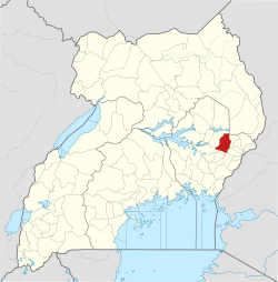
Kumi District is a district in the Eastern Region of Uganda. The town of Kumi hosts the district headquarters.

<span class="mw-page-title-main">Pallisa District</span> District in Eastern Uganda, Uganda

Pallisa District is a district in Eastern Uganda which was curved out of Tororo district in 1991. Like most other Ugandan districts, it is named after its chief town, Pallisa, where the district headquarters are located.

<span class="mw-page-title-main">Soroti District</span> District in Eastern Uganda, Uganda

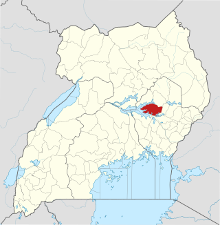
Soroti District is a district in Eastern Uganda. It is named after its chief municipal, administrative and commercial headquarters, Soroti, where the district headquarters are located.

<span class="mw-page-title-main">Kyenjojo District</span> District in Western Region of Uganda, Uganda

Kyenjojo District is a district in the Western Region of Uganda. Kyenjojo town is the site of the district headquarters.

<span class="mw-page-title-main">Soroti</span> Ugandan town

Soroti is a city in Eastern Region of Uganda. It is the main city, commercial, and administrative center in Soroti District, one of the nine administrative districts in the Teso sub-region. Soroti city was immediately approved for operationalization ahead of schedule by the Parliament of Uganda in the Financial Year 2020/2021.

<span class="mw-page-title-main">Moroto Town</span> Place in Northern Region, Uganda

Moroto is a town in Moroto District in the Northern Region of Uganda. The town serves as the location of the district headquarters.

Teso sub-region is a sub-region in Eastern Region, Uganda that consists of:

<span class="mw-page-title-main">Amuria District</span> District in Eastern Uganda, Uganda

Amuria District is a district in the Eastern Region of Uganda. The town of Amuria serves as the district headquarters.

Kumi Town, commonly called Kumi, is a town in the Eastern Region of Uganda. It is the main municipal, administrative, and commercial center in Kumi District and is the site of the district headquarters.

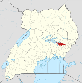
Bukedea is a town in the Eastern Region of Uganda. It is the chief municipal, administrative, and commercial center of Bukedea District, and the district headquarters are located there.

<span class="mw-page-title-main">Bulambuli District</span> District in Uganda

Bulambuli District is a district in Eastern Uganda. The district is named after 'chief town', Bulambuli, where the district headquarters are located.

<span class="mw-page-title-main">Serere District</span> District in Uganda

Serere District is a district in Eastern Uganda. It is named after its 'chief town', Serere, which serves as the district headquarters.

<span class="mw-page-title-main">Ngora District</span> District in Eastern Region of Uganda, Uganda

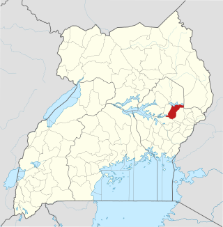
Ngora District is a district in the Eastern Region of Uganda. The town of Ngora is the site of the district headquarters.

Ngora is a town in the Eastern Region of Uganda. It is the main political, administrative, and commercial centre of Ngora District.

Ngora Freda Carr Hospital, commonly known as Ngora Hospital, is a community hospital in Uganda. It is affiliated with the Anglican Church of Uganda. It was founded in 1922. It has capacity of 180 beds.

Atutur General Hospital, also Atutur Hospital, is a government-owned hospital in the Eastern Region of Uganda.

References

  1. "Road Distance Between Soroti And Bukedea With Map". Globefeed.com. Retrieved 17 May 2014.
  2. "Uganda Districts". Statoids. 30 June 2015. Retrieved 5 March 2016.
  3. "Bukedea". Commonwealth Network. Nexus Strategic Partnerships Limited. Retrieved 5 March 2016.
  4. "Estimated Population of Bukedea District In 1991, 2002 & 2012". Citypopulation.de. Retrieved 17 May 2014.