Bukedea

Last updated
Bukedea
Uganda location map.svg
Red pog.svg
Bukedea
Map of Uganda showing the location of Bukedea.
Coordinates: 01°20′51″N34°02′40″E / 1.34750°N 34.04444°E / 1.34750; 34.04444 Coordinates: 01°20′51″N34°02′40″E / 1.34750°N 34.04444°E / 1.34750; 34.04444
Country Uganda
Region Eastern Region of Uganda
Sub-region Teso sub-region
District Bukedea District
Government
   Member of Parliament John Bosco Ikojo
Elevation
1,125 m (3,691 ft)
Population
 (2020 Estimate)
  Total13,900
Time zone UTC+3 (EAT)

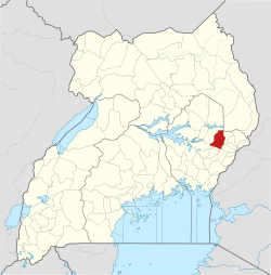
Bukedea is a town in the Eastern Region of Uganda. It is the chief municipal, administrative, and commercial center of Bukedea District, and the district headquarters are located there. [1]

Contents

Location

Bukedea is situated on the main highway (A-109) between Mbale and Soroti. It is approximately 69 kilometres (43 mi), by road, southeast of Soroti, the largest city in Teso sub-region. [2] This is approximately 35 kilometres (22 mi), by road, northwest of Mbale, the largest city in Uganda's Eastern Region. [3] The coordinates of the town are:01 20 51N, 34 02 40E (Latitude:1.347500; Longitude:34.044444). [4]

Population

According to the Uganda Bureau of Statistics (UBOS), the population of Bukedea Town in 2015, was 11,300. In 2020, UBOS estimated the mid-year population of the town at 13,900, of whom 7,000 (50.4 percent) were females and 6,900 (49.6 percent) were male. The population of the town was calculated to grow at an estimated rate of 4.23 percent annually between 2015 and 2020. [5]

Historical population
YearPop.±%
201511,300    
202013,900+23.0%
source: [5]

Points of interest

The following points of interest are located within the town limits or close to the edges of town: [4] (a) the headquarters of Bukedea District Administration (b) the offices of Bukedea Town Council (c) a mobile branch of PostBank Uganda (d) Bukedea central market, the source of fresh daily produce and (e) the Tororo–Mbale–Soroti Road passes through town in a general southeast to northwest direction. [6]

The area member of parliament (MP), is John Bosco Ikojo, a member of the ruling National Resistance Movement political party, who serves as the chairperson of the Parliamentary Committee on the National Economy in the 11th Parliament (2021–2026). [7]

See also

Related Research Articles

Soroti District District in Eastern Uganda, Uganda

Soroti District is a district in Eastern Uganda. It is named after its chief municipal, administrative and commercial headquarters, Soroti, where the district headquarters are located.

Soroti Ugandan town

Soroti is a city in Eastern Region of Uganda. It is the main City, commercial, and administrative center in curved out of Soroti District, one of the nine administrative districts in the Teso sub-region. Soroti City was immediately approved for operationalization ahead of schedule by the Parliament of Uganda in the Financial Year 2020/2021

Tororo Place in Eastern Region of Uganda, Uganda

Tororo is a town in the Eastern Region of Uganda. It is the main municipal, administrative, and commercial center of Tororo District.

Moroto Town Place in Northern Region, Uganda

Moroto is a town in Moroto District in the Northern Region of Uganda. It is the location of the district headquarters.

Budaka is a town in the Eastern Region of Uganda. It is the chief town of Budaka District, and the district headquarters are located there.

Bugiri is a town in the Eastern Region of Uganda. It is the chief town of Bugiri District, and the district headquarters are located there. The town was elevated to Municipal Council status in 2019.

Iganga is a town in the Eastern Region of Uganda. It is the main municipal, administrative, and commercial center of Iganga District.

Katakwi is a town in the Eastern Region of Uganda. It is the main municipal, administrative, and commercial center of Katakwi District and the site of the district headquarters. It borders Moroto District.

Kaberamaido is a town in Eastern Uganda. It is the main municipal, administrative and commercial center of Kaberamaido District and is the location of the headquarters for the district.

Amuria is a town in the Eastern Region of Uganda. It is the chief municipal, administrative, and commercial center of Amuria District, in the Teso sub-region.

Butaleja is a town in Eastern Rgion of Uganda. It is the main municipal, administrative and commercial center of Butaleja District and the district headquarters are located there. The district is named after the town.

Kumi Town, commonly called Kumi, is a town in the Eastern Region of Uganda. It is the main municipal, administrative, and commercial center in Kumi District and is the site of the district headquarters.

Isingiro is a town in the Western Region of Uganda. It is the main municipal, administrative, and commercial center of Isingiro District and the site of the district's headquarters.

Busolwe is a town in the Eastern Region of Uganda. It is one of the two municipalities in Butaleja District, the other being Butaleja.

Bukedea District District in Eastern Region of Uganda, Uganda

Bukedea District is a district in the Eastern Region of Uganda. The town of Bukedea is the site of the district headquarters.

Abim is a town in the Northern Region of Uganda. It is the chief municipal, administrative, and commercial center of Abim District. The district is named after the town.

Nagongera is a town in Tororo District, in the Eastern Region of Uganda.

Bududa is a town in the Eastern Region of Uganda. It is the main municipal, administrative, and commercial center of Bududa District.

Ngora is a town in the Eastern Region of Uganda. It is the main political, administrative, and commercial centre of Ngora District.

Ngora Freda Carr Hospital, commonly known as Ngora Hospital, is a community hospital in Uganda. It is affiliated with the Anglican Church of Uganda. It was founded in 1922. It has capacity of 180 beds.

References

  1. Mindat.org (22 July 2021). "Bukedea Town Council, Bukedea County, Bukedea District, Eastern Region, Uganda". Mindat.org. Retrieved 22 July 2021.
  2. Google (30 December 2020). "Road Distance Between Soroti, Uganda And Bukedea, Uganda" (Map). Google Maps . Google. Retrieved 30 December 2020.
  3. Google (30 December 2020). "Road Distance Between Bukedea And Mbale" (Map). Google Maps . Google. Retrieved 30 December 2020.
  4. 1 2 Google (3 July 2015). "Location of Bukedea, Uganda" (Map). Google Maps . Google. Retrieved 3 July 2015.
  5. 1 2 Uganda Bureau of Statistics (14 June 2020). "Estimated Population of Bukedea, Uganda" (Citypopulation.de Quoting Uganda Bureau of Statistics). Citypopulation.de. Retrieved 30 December 2020.
  6. Google (22 July 2021). "Map Showing Tororo–Mbale–Soroti Road Going Through Bukedea Town Council, Uganda" (Map). Google Maps . Google. Retrieved 22 July 2021.
  7. Franklin Draku and Arthur Arnold Wadero (16 July 2021). "What Lies Ahead For House Committees". Daily Monitor . Kampala, Uganda. Retrieved 22 July 2021.