Otuke District

Last updated

Otuke District
Otuke District in Uganda.svg
District location in Uganda
Coordinates: 02°30′N33°30′E / 2.500°N 33.500°E / 2.500; 33.500
CountryFlag of Uganda.svg  Uganda
Region Northern Uganda
Sub-region Lango sub-region
Otuke 1 July 2009
Area
  Total1,549.8 km2 (598.4 sq mi)
Elevation
1,200 m (3,900 ft)
Population
 (2012 est.)
  Total86,000
  Density55.5/km2 (144/sq mi)
Time zone UTC+3 (EAT)
Website www.otuke.go.ug

Otuke District is a district in Northern Uganda. Like many other Ugandan districts, Otuke district is named after its 'chief town', Otuke, where the district headquarters are located.

Contents

Location

Otuke District is bordered by Agago District to the north, Abim District to the northeast, Napak District to the east, Amuria District to the southeast, Alebtong District to the south, Lira District to the southwest and Pader District to the northwest. Otuke, where the district headquarters are located, lies approximately 66 kilometres (41 mi), by road, east of Lira, the largest city in the sub-region. [1] The coordinates of the district are:02 30N, 33 30E (Latitude:2.5000; Longitude:33.5000).

Overview

Otuke District was carved out of Lira District effective 1 July 2009. [2] The district is administered by the Otuke District Administration, with its headquarters at Otuke. Otuke is among the nine districts that make up Lango sub-region, which consists of the districts listed below. Lango sub-region was home to an estimated 1.5 million Langi, in 2002, according to the national census conducted that year.

Population

In 1991, the district population was estimated at 43,500. The 2002 national census estimated the population of the district at approximately 62,000. In 2012, the population of Otuke District was estimated at 86,000. [3]

See also

Related Research Articles

<span class="mw-page-title-main">Lango people</span> Ugandan ethnic group

The Lango are a Nilotic ethnic group. They live in north-central Uganda, in a region that covers the area formerly known as the Lango District until 1974, when it was split into the districts of Apac and Lira, and subsequently into several additional districts. The current Lango Region now includes the districts of Amolatar, Alebtong, Apac, Dokolo, Kole, Lira, Oyam, Otuke, and Kwania. The total population of Lango District is currently about 2,884,000.

<span class="mw-page-title-main">Pader District</span> District in Northern Uganda, Uganda

Pader District is a district in Northern Uganda. It is named after Pader, the chief municipal, administrative and commercial town in the district, where the district headquarters are located.

<span class="mw-page-title-main">Kaberamaido District</span> District in Eastern Uganda, Uganda

Kaberamaido is a district in Eastern Uganda. Like most other Ugandan districts, it is named after its 'chief town', Kaberamaido, where the district headquarters are located.

<span class="mw-page-title-main">Apac District</span> District in Northern Region, Uganda

Apac District is a district in the Northern Region of Uganda. The Town of Apac hosts the district headquarters.

<span class="mw-page-title-main">Lira District</span> District in Northern Uganda, Uganda

Lira District is a district in Northern Uganda. Like many other Ugandan districts, it is named after its 'chief town', Lira.

<span class="mw-page-title-main">Apac</span> Ugandan town

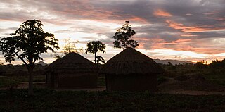
Apac is a town in Apac District in the Northern Region of Uganda. It is the 'chief town' of the district and the district headquarters are located there. The district is named after the town.

<span class="mw-page-title-main">Lango sub-region</span>

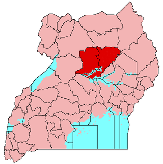
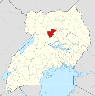
Lango sub-region is a region in Uganda covering an area of 15,570.7km consisting of the districts of:

<span class="mw-page-title-main">Amolatar District</span> District in Northern Uganda, Uganda

Amolatar District is a district in Northern Uganda. Like many other Ugandan districts, it is named after its main municipal and administrative centre, Amolatar Town.

<span class="mw-page-title-main">Dokolo District</span> District in Northern Region, Uganda

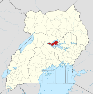
Dokolo District is a district in the Northern Region of Uganda. The town of Dokolo is its main municipal, administrative, and commercial centre.

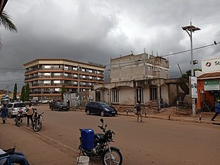
Dokolo is a town in the Northern Region of Uganda. It is the main municipal, administrative, and commercial centre of Dokolo District.

Oyam is a town in the Northern Region of Uganda. It is the primary municipal, administrative, and commercial centre of Oyam District.

<span class="mw-page-title-main">Oyam District</span> District in Northern Uganda, Uganda

Oyam District is a district in Northern Uganda. Like most Ugandan districts, it is named after its 'chief town', Oyam, where the district headquarters are located.

<span class="mw-page-title-main">Abim District</span> District in Uganda

Abim District is a district in Northern Uganda. It is named after its 'chief town', Abim, where the district headquarters are located.

<span class="mw-page-title-main">Zombo District</span> District in Northern Uganda, Uganda

Zombo District is a district in the Northern Region of Uganda. The town of Zombo is the district's main municipal, administrative, and commercial center,

<span class="mw-page-title-main">Agago District</span> District in Northern Uganda, Uganda

The Agago District is a Ugandan district located in the Northern Region of Uganda.

<span class="mw-page-title-main">Kole District</span> District in Northern Uganda, Uganda

Kole District is a district in Northern Uganda. Like most other Ugandan districts, it is named after its 'chief town', Kole, where the district headquarters are located.

<span class="mw-page-title-main">Alebtong District</span> District in Northern Region of Uganda, Uganda

Alebtong District is a district in the Northern Region of Uganda. The town of Alebtong serves as the district headquarters.

Alebtong is a town in the Northern Region of Uganda. It is the chief municipal, administrative, and commercial centre of Alebtong District. The district is named after the town.

<span class="mw-page-title-main">Napak District</span> District in Northern Uganda, Uganda

Napak District is a district in Northern Uganda. It is named after Mount Napak, and its headquarters is at Lokitede.

<span class="mw-page-title-main">Sheema District</span> District in Western Uganda, Uganda

Sheema District is a district in Western Uganda.

References

  1. "Approximate Distance Between Lira And Otuke With Map". Globefeed.com. Retrieved 22 May 2014.
  2. Vision Reporters (22 April 2010). "Government Names 14 New Districts". New Vision. Archived from the original on 29 October 2013. Retrieved 22 May 2014.
  3. "Estimated Population of Otuke District In 1991, 2002 & 2012". Citypopulation.de. Retrieved 22 May 2014.