
Kabarole District is a district in Western Uganda. Kabarole District is part of the Tooro Kingdom. Its main town was Fort Portal before 1 July 2020 when it was elevated to a city, separating it from Kabarole district. The new Kabarole district seat is proporsed in Busoro Town Council. Kabarole remains with only one county (Burahya). Bunyangabu county was curved out to form Bunyangabu district in 2017. Fort Portal Municipality constituency became Fort Portal City in 2020 with an independent local Government.

Bundibugyo District is a district in the Western Region of Uganda, bordering the Democratic Republic of the Congo (DRC). The town of Bundibugyo is where both the district headquarters and the Bwamba Kingdom seat are located. Before July 2010, the districts of Ntoroko and Bundibugyo were one. These districts are the only two in Uganda that lie west of the Rwenzori mountains. Bundibugyo was first named Semuliki district on separating it from the Greator Kabarole district alongside Rwenzori district (Kasese) in 1974.

Hoima District is a district in Western Uganda. Like most other Ugandan districts, it is named after its main municipal centre, Hoima.
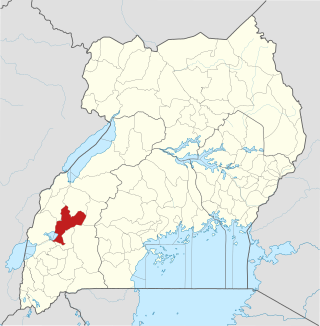
Kamwenge District is a district in Western Uganda. It is named after its 'chief town', Kamwenge, where the district headquarters are located. Kamwenge District is part of the Kingdom of Toro, one of the ancient traditional monarchies in Uganda. The kingdom is coterminous with Toro sub-region. The districts that constitute the sub-region are: (a) Bunyangabu District (b) Kabarole District (c) Kamwenge District (d) Kyegegwa District (e) Kitagwenda District and (f) Kyenjojo District.

Kasese District is a district in Western Uganda. Like most other Ugandan districts, it is named after its chief town and district headquarters, the town of Kasese.

Kibaale District, is a district in the Western Region of Uganda. The district headquarters are in the town of Kibaale.

Kasese is a town in the Western Region of Uganda. It is the capital of Kasese District. Kasese is also the largest town in the Rwenzururu region. In 2020 it had an estimated population 115,400. It lies north of Lake George and east of Rwenzori Mountains.

Bundibugyo is a town in the Western Region of Uganda. It is the 'chief town' of Bundibugyo District and the district headquarters are located there.
Rwimi is a town in Bunyangabu District in the Western Region of Uganda. With an estimated population of 16,200 in 2020 it is the largest urban center in the district, but the district headquarters are located elsewhere; in Kibiito.

Buhweju District is a district in Western Uganda. It is one of the districts that constitute the Ankole sub-region. Its 'chief town', is Nsiika.
Ntoroko is a town officially known as Kanara Town Council in Ntoroko District Western Uganda. It is one of the four town councils of Ntoroko District the others being Karugutu, Rwebisengo and Kibuku Town Council. Ntoroko is the largest fishing town on the southern Mwitanzige shore. Its located on the Ntoroko bay extending from Kanara Fishing village to the western half of the Ntoroko Peninsula. The peninsular also separates Ntoroko bay from the Muziizi Bay. By Road, Ntoroko town is approximately 84 KM Northwest of Fort Portal City, the regional Capital and approximately 79 KM via Karugutu, north of Kibuku Town Council the District Capital. Ntoroko/Kanara Town Council is settled by many ethnicities, the largest being; Rwenzori Peoples; Batooro/Batuku, Bakonzo, Bamba, Babwisi. Bunyoro peoples; Bagangaizi, Bagungu and other Banyoro. Alur, Lendu and Ngite. Congolese of the Western Mwitanzige shore; Alur, Gegere, Nande, to mention but a few.
Bugoye is a small town in Western Uganda.
Kilembe is a community in Kasese District, in the Western Region of Uganda.
Kagadi District is a district in the Western Region of Uganda.
Bunyangabu District is a district in the Western Region of Uganda. The town of Kibiito is the political and administrative center of the district. However, the town of Rwimi, is the largest and main commercial center of Bunyangabu.
Kibiito is a town in the Western Region of Uganda. It is the chief administrative center of Bunyangabu District, and the district headquarters are located there.
Rubona is a town in the Western Region of Uganda.
The Nkenda–Fort Portal–Hoima High Voltage Power Line is a high voltage electricity power line, in operation, connecting the high voltage substation at Nkenda, Kasese District, to another high voltage substation at Kabaale, Buseruka sub-county, Hoima District, all in the Western Region of Uganda.
Karugutu is a settlement in the Western Region of Uganda. The name "Karugutu" applies to;
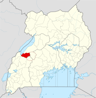
Kitagwenda District is a district in Western Uganda. The district is named after Kitagwenda County, which is coterminous with the district.
