
Ankole was a traditional Bantu kingdom in Uganda and lasted from the 15th century until 1967. The kingdom was located in south-western Uganda, east of Lake Edward.

Ntungamo District is a district in Western Uganda. Like most Ugandan districts, it is named after its 'chief town', Ntungamo, the location of the district headquarters. Ntungamo was elevated to a district on 5th May 1993.

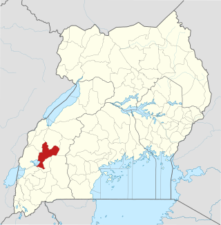
Mbarara District is a district in South Western Uganda. In 2019, the Ugandan Cabinet approved part of Mbarara District, the then-Mbarara municipality, to be upgraded to city status effective July 2020.
Kamwenge District is a district in Western Uganda. It is named after its 'chief town', Kamwenge, where the district headquarters are located. Kamwenge District is part of the Kingdom of Toro, one of the ancient traditional monarchies in Uganda. The kingdom is coterminous with Toro sub-region. The districts that constitute the sub-region are: (a) Bunyangabu District (b) Kabarole District (c) Kamwenge District (d) Kyegegwa District (e) Kitagwenda District and (f) Kyenjojo District.

Bushenyi is a town in Western Uganda. It is the 'chief town' of Bushenyi District and the site of the district headquarters. The district is named after the town, in keeping with the practice in most of the districts in the country.
Nkore is a Bantu language spoken by the Nkore ("Banyankore") of south-western Uganda in the former province of Ankole, as well as in Tanzania, the DR Congo, Rwanda and Burundi.

Ibanda District is a district in the Western Region of Uganda. The town of Ibanda is the site of the district headquarters.

Kiruhura District is a district in the Western Region of Uganda. The town of Rushere is the site of the district headquarters.

Sheema, also Sheema Municipality, is an urban centre in the Western Region of Uganda. It is the largest municipality in Sheema District.
Ankole sub-region is a region in the Western Region of Uganda that consists of the following districts:

Rubirizi District is a district in Western Uganda. Like most Ugandan districts, the district is named after its 'chief town', Rubirizi, where the district headquarters are located.
Rubirizi, sometimes spelled Rubiriizi, is a town in Rubirizi District, Ankole sub-region, Western Uganda. The town is the main municipal, administrative and commercial center of Rubirizi District. The district is named after the town.

Buhweju District is a district in Western Uganda. It is one of the districts that constitute the Ankole sub-region. Its 'chief town', is Nsiika.

itooma District is a district in Western Uganda. It is named after its main municipal, administrative and commercial center, Mitooma.
Mitooma, also Mitoma, is a town in the Western Region of Uganda. It is the main municipal, administrative, and commercial center of Mitooma District.

Sheema District is a district in Western Uganda.
Kibingo is a town in Western Uganda. It is the location of the district headquarters of Sheema District.
Kitagata is a town in Western Uganda. It is one of the urban centers in Sheema District.
Ishaka Adventist Hospital is a rural hospital in Uganda. The hospital is located in the town of Ishaka, Bushenyi District, Western Uganda. It is located immediately north of the junction where the Ishaka–Kagamba Road meets the Mbarara–Ishaka Road. It is approximately 61 kilometres (38 mi) west of Mbarara, the largest city in the sub-region. This location lies approximately 329 kilometres (204 mi), by road, southwest of Kampala, the capital of Uganda and the largest city in that country. The geographical coordinates of Ishaka Adventist Hospital are: 0°32'38.0"S, 30°08'17.0"E.
The Kashenyi–Mitooma Road in the Western Region of Uganda connects the town of Kashenyi in Bushenyi District with the town of Mitooma in Mitooma District. The road measures approximately 12 kilometres (7.5 mi).


