Sheema District

Last updated

Sheema District
Sheema District in Uganda.svg
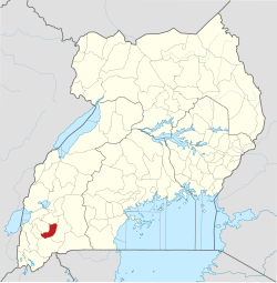
District location in Uganda
Coordinates: 00°32′S30°24′E / 0.533°S 30.400°E / -0.533; 30.400
CountryFlag of Uganda.svg  Uganda
Region Western Uganda
Sub-region Ankole sub-region
Capital Kibingo
Area
  Land699.1 km2 (269.9 sq mi)
Elevation
1,500 m (4,900 ft)
Population
 (2012 Estimate)
  Total220,200
  Density315/km2 (820/sq mi)
Time zone UTC+3 (EAT)
Area code 101
Website www.sheema.go.ug

Sheema District is a district in Western Uganda.

Location

Sheema District is bordered by Buhweju District to the north, Mbarara District to the east, Ntungamo District to the south, Mitooma District to the southwest and Bushenyi District to the west. Kibingo, where the district headquarters are located, [1] lies approximately 33 kilometres (21 mi) west of Mbarara, the largest city in Ankole sub-region. [2] The coordinates of the district are:00 32S, 30 24E.

Contents

Overview

Sheema District was created by an Act of the Ugandan Parliament, becoming operational on 1 July 2010. Prior to that, the district was known as Sheema County and was part of Bushenyi District. The district is part of Ankole sub-region. The districts that compose Ankole sub-region include the following districts: 1. Buhweju District 2. Bushenyi District 3. Ibanda District 4. Isingiro District 5. Kiruhura District 6. Mitooma District 7. Ntungamo District 8. Rubirizi District and 9. Sheema District. The sub-region was home to an estimated 2.2 million people in 2002, according to the national census conducted that year.

Population

In 1991, the national census estimated the district population at about 153,000. The national census in 2002 estimated the population of the district at about 180,200. In 2012, the population of Sheema District was estimated at approximately 220,200. [3]

See also

Related Research Articles

<span class="mw-page-title-main">Ankole</span> Former country

Ankole was a traditional Bantu kingdom in Uganda and lasted from the 15th century until 1967. The kingdom was located in south-western Uganda, east of Lake Edward.

<span class="mw-page-title-main">Ntungamo District</span> District in Western Uganda, Uganda

Ntungamo District is a district in Western Uganda. Like most Ugandan districts, it is named after its 'chief town', Ntungamo, the location of the district headquarters. Ntungamo was elevated to a district on 5th May 1993.

<span class="mw-page-title-main">Mbarara district</span> District in Western Uganda, Uganda

Mbarara District is a district in South Western Uganda. In 2019, the Ugandan Cabinet approved part of Mbarara District, the then-Mbarara municipality, to be upgraded to city status effective July 2020.

<span class="mw-page-title-main">Bushenyi District</span> District in Western Uganda, Uganda

Bushenyi District is a district in Western Uganda. Like many other Ugandan districts, it is named after its chief town, Bushenyi, where the district headquarters are located.

Mbarara University of Science & Technology (MUST), commonly known as Mbarara University, is a public university in Uganda. Mbarara University commenced student intake and instruction in 1989. It is one of the ten public universities and degree-awarding institutions in the country. MUST is accredited by the Uganda National Council for Higher Education.

<span class="mw-page-title-main">Bushenyi</span> Place in Western Uganda, Uganda

Bushenyi is a town in Western Uganda. It is the 'chief town' of Bushenyi District and the district headquarters are located there. The district is named after the town, in keeping with the practice in most of the districts in the country.

<span class="mw-page-title-main">Ibanda District</span> District in Western Region, Uganda

Ibanda District is a district in the Western Region of Uganda. The town of Ibanda is the site of the district headquarters.

<span class="mw-page-title-main">Isingiro District</span> District in Western Uganda, Uganda

Isingiro District is a district in the Western Region of Uganda. The town of Isingiro is the district's main municipal, administrative, and commercial center.

<span class="mw-page-title-main">Kiruhura District</span> District in Western Region, Uganda

Kiruhura District is a district in the Western Region of Uganda. The town of Rushere is the site of the district headquarters.

Sheema, also Sheema Municipality, is an urban centre in the Western Region of Uganda. It is the largest municipality in Sheema District.

Ishaka is a town in the Western Region of Uganda. It is one of the municipalities in Bushenyi District.

Ankole sub-region is a region in the Western Region of Uganda that consists of the following districts:

<span class="mw-page-title-main">Rubirizi District</span> District in Western Uganda, Uganda

Rubirizi District is a district in Western Uganda. Like most Ugandan districts, the district is named after its 'chief town', Rubirizi, where the district headquarters are located.

<span class="mw-page-title-main">Buhweju District</span> District in Western Uganda, Uganda

Buhweju District is a district in Western Uganda. It is one of the districts that constitute the Ankole sub-region. Its 'chief town', is Nsiika.

<span class="mw-page-title-main">Mitooma District</span> District in Uganda

Mitooma District is a district in Western Uganda. It is named after its main municipal, administrative and commercial center, Mitooma.

Mitooma, also Mitoma, is a town in the Western Region of Uganda. It is the main municipal, administrative, and commercial center of Mitooma District.

Kibingo is a town in Western Uganda. It is the location of the district headquarters of Sheema District.

Ishaka Adventist Hospital is a rural hospital in Uganda. The hospital is located in the town of Ishaka, Bushenyi District, Western Uganda. It is located immediately north of the junction where the Ishaka–Kagamba Road meets the Mbarara–Ishaka Road. It is approximately 61 kilometres (38 mi) west of Mbarara, the largest city in the sub-region. This location lies approximately 329 kilometres (204 mi), by road, southwest of Kampala, the capital of Uganda and the largest city in that country. The geographical coordinates of Ishaka Adventist Hospital are: 0°32'38.0"S, 30°08'17.0"E.

Rubindi is a town in Mbarara District, Greater Mbarara region, Ankole sub-region, Western Uganda.

References

  1. Joyce Namutebi, and Catherine Bekunda (4 May 2010). "Parliament Approves 16 New Districts". New Vision. Archived from the original on 21 May 2014. Retrieved 20 May 2014.
  2. "Map Showing Mbarara And Kibingo With Distance Marker". Globefeed.com. Retrieved 20 May 2014.
  3. "Estimated Population of Sheema District In 1991, 2002 & 2012". Citypopulation.de. Retrieved 20 May 2014.