Nebbi District is a district in Northern Uganda. It is named after its main municipal, commercial and administrative centre, Nebbi, the location of the district headquarters.

Arua is a city and commercial centre within the Arua District in the Northern Region of Uganda.

Pakwach is a town in the Northern Region of Uganda. It is the main commercial, political and administrative center of Pakwach District. In the 19th century the town came under brief occupation by the Ottoman branch of the Khedivate of Egypt, as part of Hatt-ı Üstuva (Equatoria) Vilayet.
Nebbi is a town in the Nebbi District of the Northern Region of Uganda. It is the site of the district headquarters.

Maracha District is a district in the West Nile sub-region, in the Northern Region of Uganda. It was formed in 2006 from Arua District.
Okollo is a town in Arua District, northwestern Uganda.
Goli is a town in the Northern Region of Uganda.
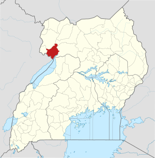
Zombo District is a district in the Northern Region of Uganda. The town of Zombo is the district's main municipal, administrative, and commercial center,
Zombo, Uganda, often referred to simply as Zombo, is a town in Zombo District, West Nile sub-region, Northern Uganda.
Muni University (MU) is a public multi-campus university in Uganda. It is one of the public universities and degree-awarding institutions in the country, licensed and supervised by the Uganda National Council for Higher Education (UNCHE).
Olwiyo is a town in Nwoya District in the Northern Region of Uganda.

Karuma is a settlement in the Western Region of Uganda.
The Karuma–Olwiyo–Pakwach–Nebbi–Arua Road is a road in the Northern Region of Uganda, connecting the towns of Karuma, Olwiyo, Pakwach, Nebbi and the city of Arua.
Maracha is a town in the West Nile sub-region, in Northern Uganda. It is the main municipal, administrative and commercial center of Maracha District and the headquarters of the district are located there. The district is named after the town.

Omoro District is a district in the Northern Region of Uganda.
The Karuma–Kawanda High Voltage Power Line is a high voltage electricity power line, under construction, connecting the high voltage substation at Karuma Hydroelectric Power Station, in the Western Region of Uganda, to another high voltage substation at Kawanda, in the Central Region of Uganda.
The Lira–Gulu–Nebbi–Arua High Voltage Power Line is an operational high voltage electricity power line in Uganda. It connects the high voltage substation at Lira, in Lira District, to another high voltage substation at Arua, in Arua District, all in the Northern Region of the country.
The Kampala–Gulu Highway, also Kampala–Gulu Road, is a road connecting Uganda's capital city of Kampala, in the Central Region, with the city of Gulu, the largest urban centre in the country's Northern Region.
Holy Family Hospital Nyapea, commonly referred to as Nyapea Hospital, is a faith-based community hospital in Nyapea, Zombo District, in the Northern Region of Uganda. It is a private, non-profit, hospital, serving the town of Nyapea and surrounding areas of West Nile sub-region.
Panyimur is a town in the Pakwach District of the Northern Region of Uganda. Panyimur may also refer to Panyimur sub-county, one of the five administrative subdivisions that constitute Pakwach District.


