Nebbi

Last updated
Nebbi
Uganda location map.svg
Red pog.svg
Nebbi
Location in Uganda
Coordinates: 02°28′45″N31°05′24″E / 2.47917°N 31.09000°E / 2.47917; 31.09000
Country Flag of Uganda.svg Uganda
Region Northern Region of Uganda
Sub-region West Nile sub-region
District Nebbi District
Elevation
3,287 ft (1,002 m)
Population
 (2020 Estimate)
  Total41,400 [1]

Nebbi is a town in the Nebbi District of the Northern Region of Uganda. It is the site of the district headquarters. [2]

Contents

Location

Nebbi is located in the West Nile sub-region, along the Karuma–Olwiyo–Pakwach–Nebbi–Arua Road, approximately 80 kilometres (50 mi), south-east of Arua, the largest city in the West Nile sub-region. [3] This is approximately 173 kilometres (107 mi), by road, south-west of Gulu, the largest city in the Northern Region of Uganda. [4] The coordinates of the town are 2°28'45.0"N, 31°05'24.0"E (Latitude:2.479167; Longitude:31.0900). [5] Nebbi Town sits at an average elevation of 1,002 metres (3,287 ft), above mean sea level. [6]

Population

The 2002 national census put the population of Nebbi at about 22,740. In 2010, the Uganda Bureau of Statistics (UBOS) estimated the population at 28,000. In 2011, UBOS estimated the mid-year population at 28,800. [7] The 2014 census put the population at 35,029. [1]

In 2020, UBOS estimated the mid-year population of Nebbi Town Council at 41,400 people. The population agency calculated the annual population growth rate of the municipality at 2.9 percent, between 2014 and 2020. [1]

Historical population
YearPop.±%
200222,740    
201028,000+23.1%
201128,800+2.9%
201435,029+21.6%
202041,400+18.2%
source: [1] [7]

Points of interest

The following additional points of interest lie in the town or near the town limits: [5]

1. The Offices of Nebbi District Local Government Headquarters

2. The Offices of Nebbi Municipal Council

3. Nebbi Central Market

4. Nebbi General Hospital, a 108-bed public hospital owned by the Uganda Ministry of Health and administered by Nebbi District Local Government.

5. Nebbi Airstrip, owned by the Uganda Civil Aviation Authority

6. Nyacara Church, a place of worship affiliated with the Church of Uganda

7. Afere Church, a place of worship affiliated with the Church of Uganda

8. The headquarters of the Roman Catholic Diocese of Nebbi

9. Nebbi Town Public Library

10. Nebbi Roman Catholic Cathedral. [5]

Photos

Related Research Articles

<span class="mw-page-title-main">Nebbi District</span> District in Northern Uganda, Uganda

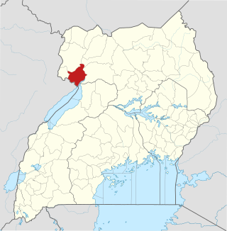
Nebbi District is a district in Northern Uganda. It is named after its main municipal, commercial and administrative centre, Nebbi, the location of the district headquarters.

<span class="mw-page-title-main">Lira, Uganda</span> Place in Northern Region of Uganda, Uganda

Lira is a city in the Northern Region of Uganda. It is the main municipal, administrative, and commercial centre of Lira District.

<span class="mw-page-title-main">Mbale</span> Place in Eastern Uganda, Uganda

Mbale is a city in the Eastern Region of Uganda. It is the main municipal, administrative, and commercial center of Mbale District and the surrounding sub-region.

<span class="mw-page-title-main">Masindi</span> Place in Western Region of Uganda, Uganda

Masindi is a town in the Western Region of Uganda. It is on the road between Kampala and the Murchison Falls National Park. It is the site of the headquarters of the Masindi District.

<span class="mw-page-title-main">Arua</span> Place in Northern Region, Uganda

Arua is a city and commercial centre within the Arua District in the Northern Region of Uganda.

<span class="mw-page-title-main">Adjumani</span> Ugandan town

Adjumani is a town in the Northern Region of Uganda. It is the main municipal, administrative, and commercial centre of Adjumani District. The district is named after the town.

Mayuge is a town in the Eastern Region of Uganda. It is the location of the headquarters of Mayuge District.

Yumbe is a town in the Northern Region of Uganda. It is the district headquarters of Yumbe District.

Moyo, is the main municipal, administrative, and commercial center of Moyo District in the Northern Region of Uganda. The district headquarters are located here.

Pakwach is a town in the Northern Region of Uganda. It is the main commercial, political and administrative center of Pakwach District. In the 19th century the town came under brief occupation by the Ottoman tributary of the Khedivate of Egypt, as part of Hatt-ı Üstuva (Equatoria) Vilayet.

Koboko is a town in Northern Region of Uganda. It is the main municipal, administrative, and commercial centre of Koboko District. Koboko is also the hometown of former dictator Idi Amin who ruled Uganda from 1971 to 1979.

<span class="mw-page-title-main">Mukono Town</span> Urban centre in Uganda

Mukono Town is a municipality in Mukono District in the Central Region of Uganda. The town is administered by the Mukono Town Council. The district headquarters are located in this town.

<span class="mw-page-title-main">Mityana</span> Place in Central Uganda, Uganda

Mityana, is a town in the Central Region of Uganda. It is the main municipal, administrative, and commercial center of Mityana District, and the district headquarters are located there.

Lyantonde is a town in the southern part of the Central Region of Uganda. It is the main municipal, administrative, and commercial center of Lyantonde District.

Wobulenzi is a municipality in Katikamu sub-county, in Luweero District in the Central Region of Uganda.

<span class="mw-page-title-main">Paidha</span> Place in Northern Region of Uganda, Uganda

Paidha is a town in the Northern Region of Uganda.

Mpondwe is a town in the Western Region of Uganda.

Nwoya is a town in Nwoya District in the Acholi sub-region, in the Northern Region of Uganda. It is the main municipal, administrative, and commercial centre of the district. Nwoya Town Council is classified as a municipality.

Katunguru, is a settlement in Rubirizi District, Ankole sub-region, in the Western Region of Uganda. The name also applies to Katunguru Sub-county and Katunguru Parish, where the settlement is located.

Namayumba is a settlement in the Wakiso District in the Buganda Region of Uganda. The name also refers to "Namayumba sub-county", the location of Namayumba settlement.

References

  1. 1 2 3 4 Uganda Bureau of Statistics (14 June 2020). "The Population of The Regions of the Republic of Uganda And All Cities And Towns of More Than 15,000 Inhabitants". Citypopulation.de Quoting Uganda Bureau of Statistics . Retrieved 10 January 2021.
  2. Places in the World (10 January 2021). "Nebbi Town Council". Uganda Places in the World. Retrieved 10 January 2020.
  3. Google (10 January 2021). "Road Distance Between Nebbi, Uganda And Arua, Uganda" (Map). Google Maps . Google. Retrieved 10 January 2021.
  4. Google (10 January 2021). "Road Distance Between Nebbi And Gulu" (Map). Google Maps . Google. Retrieved 10 January 2021.
  5. 1 2 3 Google (10 January 2021). "Location of Nebbi, Nebbi District, Uganda" (Map). Google Maps . Google. Retrieved 10 January 2021.
  6. Floodmap (10 January 2021). "Elevation of Nebbi Town Council". Floodmap.net. Retrieved 10 January 2021.
  7. 1 2 Uganda Bureau of Statistics (June 2011). "Estimated Population of Nebbi In 2002, 2010 And 2011" (PDF). Uganda Bureau of Statistics . Kampala, Uganda. Archived from the original (Archived from the original on 7 July 2014) on 7 July 2014. Retrieved 5 August 2022.