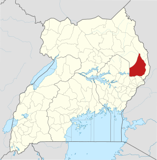
Kotido District is a district in Northern Uganda. It is named after its 'chief town', Kotido, where the district headquarters are located.

Moroto District is a district in the Northern Region of Uganda. The town of Moroto is the site of the district headquarters.
Nakapiripirit District is a district in Northern Uganda. Like many Ugandan districts, it is named after its 'chief town', Nakapiripirit, where the district headquarters are located.

Moroto is a town in Moroto District in the Northern Region of Uganda. The town serves as the location of the district headquarters.
Kotido is a town in the Northern Region of Uganda. It is the chief municipal, administrative, and commercial center of the Kotido District and the site of the district headquarters.
Nakapiripirit is a town in the Nakapiripirit District of the Northern Region of Uganda. It is the seat of the district headquarters. As an administrative unit of the district, it is one of the eight sub-counties in the district.
Amuria is a town in the Eastern Region of Uganda. It is the chief municipal, administrative, and commercial center of Amuria District, in the Teso sub-region.

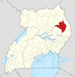
Kaabong District is a district in the Northern Region of Uganda. The district headquarters are in the similarly named town of Kaabong.

Abim District is a district in Northern Uganda. It is named after its 'chief town', Abim, where the district headquarters are located.
Abim is a town in the Northern Region of Uganda. It is the chief municipal, administrative, and commercial center of Abim District. The district is named after the town.

Kaabong is a town in the Northern Region of Uganda. It is the chief municipal, administrative and commercial center of the eponymous Kaabong District, and the district headquarters are located in the town.
Moroto Regional Referral Hospital, commonly known as Moroto Hospital is a hospital in the town of Moroto, in Northeastern Uganda. It is the referral hospital for the districts of Abim, Kaabong, Kotido, Moroto and Nakapiripirit and Napak.

The Agago District is a Ugandan district located in the Northern Region of Uganda.

Amudat District is a district in Northern Uganda. Like most Ugandan districts, it is named after its 'chief town', Amudat, where the district headquarters are located.
Amudat is a town in Northern Uganda. It is the main municipal, administrative and commercial center of Amudat District and the district headquarters are located there. The district is named after the town.
Napak is a town in Northern Uganda. It is the commercial, administrative and municipal headquarters of Napak District. The district is named after the town.
Moroto–Nakapiripirit Road is a road in the Northern Region of Uganda. The road connects the towns of Moroto, the largest town in the Karamoja sub-region, and Nakapiripirit in the same sub-region.
Muyembe is a town in the Eastern Region of Uganda.
Soroti–Amuria–Abim–Kotido Road is a road in the Eastern and Northern Regions of Uganda. The road connects the towns of Soroti in Soroti District, to Amuria in Amuria District, Abim in Abim District, and Kotido, in Kotido District. Soroti and Amuria lie in the Teso sub-region, while Abim and Kotido are in the Karamoja sub-region.
Lorengecora is a settlement in the Northern Region of Uganda. It is the headquarters of Lorengecora Parish, in Iriri sub-county, in Bokora County, in Napak District, in the Karamoja sub-region.