Amudat District

Last updated

Amudat District
Amudat District in Uganda.svg
District location in Uganda
Coordinates: 01°57′N34°57′E / 1.950°N 34.950°E / 1.950; 34.950
CountryFlag of Uganda.svg  Uganda
Region Northern Uganda
Sub-region Karamoja sub-region
Capital Amudat
Area
  Total1,615.4 km2 (623.7 sq mi)
Elevation
1,280 m (4,200 ft)
Population
 (2013 Estimate)
  Total143,300
  Density70.4/km2 (182/sq mi)
Time zone UTC+3 (EAT)
Website www.amudat.go.ug

Amudat District is a district in Northern Uganda. Like most Ugandan districts, it is named after its 'chief town', Amudat, where the district headquarters are located.

Contents

Location

Amudat District is bordered by Moroto District to the north, the Republic of Kenya to the east, Bukwa District and Kween District to the south and Nakapiripirit District to the west. Amudat, where the district headquarters are located, lies approximately 38 kilometres (24 mi), by road, northeast of Nakapiripirit, the nearest large town. [1] This location is approximately 400 kilometres (250 mi), by road, northeast of Kampala, Uganda's capital and largest city. [2] The coordinates of the district are:01 57N, 34 57E (Latitude:1.9500; Longitude:34.9500).

Overview

Amudat District was carved out of Nakapiripirit District in 2010. The district is administered by the Amudat District Administration, with headquarters at Amudat. The main ethnic group in the district are the Pokot, a group that shares a common culture and customs with the Pokot and Kalenjin of Kenya. The district is part of the Karamoja sub-region. The district that constitute Karamoja sub-region include:(a) Abim District (b) Amudat District (c) Kaabong District (d) Kotido District (e) Moroto District (f) Nakapiripirit District (g) Napak District. According to the 2002 national census, Karamoja sub-region was home to close to one million people, at that time.

Population

In 1991, the national population census determined the district population at about 11,340. The 2002 national census estimated the population in the district at approximately 63,600. The district population was determined to be growing at an annual rate of 6.1%, between 2002 and 2012. In 2012, the population of Amudat District was estimated at about 113,700. [3] In 2013, the district population, was estimated at about 143,300. [4]

See also

Related Research Articles

<span class="mw-page-title-main">Kotido District</span> District in Northern Uganda, Uganda

Kotido District is a district in Northern Uganda. It is named after its 'chief town', Kotido, where the district headquarters are located.

<span class="mw-page-title-main">Moroto District</span> District in Northern Region of Uganda, Uganda

Moroto District is a district in the Northern Region of Uganda. The town of Moroto is the site of the district headquarters.

<span class="mw-page-title-main">Nakapiripirit District</span> District in Northern Uganda, Uganda

Nakapiripirit District is a district in Northern Uganda. Like many Ugandan districts, it is named after its 'chief town', Nakapiripirit, where the district headquarters are located.

<span class="mw-page-title-main">Moroto Town</span> Place in Northern Region, Uganda

Moroto is a town in Moroto District in the Northern Region of Uganda. The town serves as the location of the district headquarters.

Kapchorwa is a town in the Eastern Region of Uganda. It is the main municipal, commercial, and administrative center of Kapchorwa District. Initially, the town of Kapchorwa was known as the Sebei Region.

Kotido is a town in the Northern Region of Uganda. It is the chief municipal, administrative, and commercial center of the Kotido District and the site of the district headquarters.

Nakapiripirit is a town in the Nakapiripirit District of the Northern Region of Uganda. It is the seat of the district headquarters. As an administrative unit of the district, it is one of the eight sub-counties in the district.

<span class="mw-page-title-main">Kaabong District</span> District in Northern Region of Uganda, Uganda

Kaabong District is a district in the Northern Region of Uganda. The district headquarters are in the similarly named town of Kaabong.

<span class="mw-page-title-main">Bukwo District</span> District in Eastern Uganda, Uganda

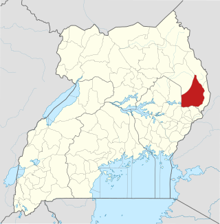
Bukwo District is a district in the Eastern Region of Uganda. The town of Bukwo is its main political, administrative, and commercial center and the site of the district headquarters.

<span class="mw-page-title-main">Abim District</span> District in Uganda

Abim District is a district in Northern Uganda. It is named after its 'chief town', Abim, where the district headquarters are located.

Abim is a town in the Northern Region of Uganda. It is the chief municipal, administrative, and commercial center of Abim District. The district is named after the town.

<span class="mw-page-title-main">Kaabong</span> Ugandan town

Kaabong is a town in the Northern Region of Uganda. It is the chief municipal, administrative and commercial center of the eponymous Kaabong District, and the district headquarters are located in the town.

<span class="mw-page-title-main">Kween District</span> District in Uganda

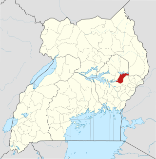
Kween District is a district in Eastern Uganda. The district headquarters are located at Binyiny, one of the two town councils in the district.

<span class="mw-page-title-main">Alebtong District</span> District in Northern Region of Uganda, Uganda

Alebtong District is a district in the Northern Region of Uganda. The town of Alebtong serves as the district headquarters.

Amudat is a town in Northern Uganda. It is the main municipal, administrative and commercial center of Amudat District and the district headquarters are located there. The district is named after the town.

<span class="mw-page-title-main">Napak District</span> District in Northern Uganda, Uganda

Napak District is a district in Northern Uganda. It is named after Mount Napak, and its headquarters is at Lokitede.

Napak is a town in Northern Uganda. It is the commercial, administrative and municipal headquarters of Napak District. The district is named after the town.

Moroto–Nakapiripirit Road is a road in the Northern Region of Uganda. The road connects the towns of Moroto, the largest town in the Karamoja sub-region, and Nakapiripirit in the same sub-region.

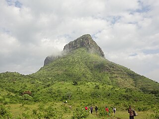
Muyembe is a town in the Eastern Region of Uganda.

Lorengecora is a settlement in the Northern Region of Uganda. It is the headquarters of Lorengecora Parish, in Iriri sub-county, in Bokora County, in Napak District, in the Karamoja sub-region.

References

  1. "Map Showing Amudat And Nakapiripirit With Distance Marker". Globefeed.com. Retrieved 14 April 2014.
  2. "Approximate Road Distance Between Kampala And Amudat With Map". Globefeed.com. Retrieved 14 April 2014.
  3. "Estimated Population of Amudat District In 1991, 2002 & 2012". Citypopulation.de. Retrieved 24 May 2014.[ permanent dead link ]
  4. Mafabi, David (12 October 2013). "Amudat Mothers Trek to Kenya to Access Treatment". Wordpress.com. Retrieved 14 April 2014.