
Masaka District is a district in Buganda Kingdom in Uganda. Its main town is Masaka City, whose estimated population in 2011 was 74,100.

Rakai District is a district in the Central Region of Uganda. The town of Rakai is the site of the district's headquarters.

Sembabule District is a district in the Central Region of Uganda. The town of Sembabule is the site of the district headquarters. Other urban centers in the district include Lwemiyaga and Ntuusi.

Apac District is a district in the Northern Region of Uganda. The Town of Apac hosts the district headquarters.

Budaka District is a district in the Eastern Region of Uganda. The town of Budaka serves as the district headquarters.

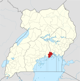
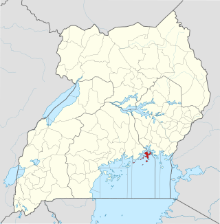
Rakai is a town in the Central Region of Uganda. It is the site of the headquarters of Rakai District. Other towns in the district include Kalisizo, Kyotera Kakuuto and Mutukula.

Kiruhura District is a district in the Western Region of Uganda. The town of Rushere is the site of the district headquarters.

Lyantonde District is a district in southern Central Uganda. It is named after the 'chief town' of the district, Lyantonde, where the district headquarters are located.
Kyazanga is a town council in the Lwengo District of the Central Region of Uganda.

Bukomansimbi District is a district in Central Uganda. The district is named after its main municipal center, Bukomansimbi, the location of the district headquarters.
Buikwe District is a district in the Central Region of Uganda. It is named after its 'chief town', Buikwe, where the district headquarters are located.

Butambala District is a district in the Central Region of Uganda.
Buvuma District is a district in the Central Region of Uganda. The district is coterminous with the Buvuma Islands archipelago in Lake Victoria and does not have territory on mainland Uganda.

Kalungu District is a district in Central Uganda. It is named after the main town of the district, Kalungu, where the district headquarters are located.
Lwengo is a town in Central Uganda. It is the chief municipal, administrative and commercial center of Lwengo District. It was known as Mbiriizi, prior to 1 July 2010.

Bulambuli District is a district in Eastern Uganda. The district is named after 'chief town', Bulambuli, where the district headquarters are located.
Zombo District is a district in the Northern Region of Uganda. The town of Zombo is the district's main municipal, administrative, and commercial center,

Kyegegwa District is a district in Western Region of Uganda. The town of Kyegegwa hosts the district headquarters.

itooma District is a district in Western Uganda. It is named after its main municipal, administrative and commercial center, Mitooma.

Sheema District is a district in Western Uganda.
