Pader District

Last updated
Pader District
Sunrise in Patongo, Pader.jpg
Pader District in Uganda.svg
District location in Uganda
Coordinates: 02°50′N33°05′E / 2.833°N 33.083°E / 2.833; 33.083
CountryFlag of Uganda.svg  Uganda
Region Northern Uganda
Sub-region Acholi sub-region
Capital Pader
Area
  Total3,362.5 km2 (1,298.3 sq mi)
Population
 (2012 Estimate)
  Total231,700
  Density68.9/km2 (178/sq mi)
Time zone UTC+3 (EAT)
Website www.pader.go.ug

Pader District is a district in Northern Uganda. It is named after Pader, the chief municipal, administrative and commercial town in the district, where the district headquarters are located.

Contents

Location

Aruu Falls in Pader District. Aruu Falls in Pader District.jpg
Aruu Falls in Pader District.

Pader District is bordered by Lamwo District to the northwest, Kitgum District to the northeast, Agago District to the east, Lotuke District to the southeast, Lira District to the south, Oyam District to the southwest and Gulu District to the west. [1] The district headquarters at Pader are located approximately 130 kilometres (81 mi), by road, northeast of Gulu, the largest city in the sub-region. [2] The coordinates of the district are:02 50N, 33 05E.

Overview

The district is relatively new, having been part of Kitgum District in the past. In December 2001, Aruu County and Agago County were carved out of Kitgum District to form Pader District. The seat of the district government, Pader, is located in the center of the district. The district, along with Amuru District, Agago District, Gulu District, Lamwo District, Nwoya District and Kitgum District, constitutes Acholi sub-region, considered to be the historical homeland of the Acholi ethnic group, and home to an estimated 1.1 million inhabitants in 2002, according to the national census conducted that year.

Population

The 1991 census estimated the district population at about 80,900. The 2002 national census estimated the population of the district at about 142,300. For the greater part of the first decade of the 2000s, the majority of the population within the district have been living in camps for internally displaced people (IDP), as the result of the Lord's Resistance War. With the cessation of hostilities between the LRA and the UPDF in 2006, the majority of the people in the IDP camps have moved back to their homes. In 2012, the population of Pader District was estimated at approximately 231,700. [3]

Economic activity

Agriculture is the backbone of the district economy. 90% of the district population engage in agriculture. The food crops grown include The following: [4]

Women pounding sorghum. Women pounding Soghum in Pader in the afternoon.jpg
Women pounding sorghum.

Cash crops include: Cotton, Groundnuts, Sunflower, Rice, Tobacco, Soya beans and Simsim. Fish farming and fish hunting are also commonly practiced.

See also

Related Research Articles

<span class="mw-page-title-main">Gulu District</span> Neucleated District in Northern Region of Uganda, Uganda

Gulu is a district in the Northern Region of Uganda. The regional headquarters are located in the city of Gulu, which is also the administrative capital of Northern Uganda. the district consists of two main divisions, Gulu West and Gulu East.

<span class="mw-page-title-main">Kitgum District</span> District in Northern Uganda, Uganda

Kitgum District is a district in Northern Uganda. It is named after its major town of Kitgum, where the district headquarters is located. It has suffered many deaths and social disruption resulting from the 20-year civil war in the region during the late 20th century. The government moved tens of thousands of residents to internally displaced persons camps for their protection, where they were subject to raids by the rebels and also harsh conditions, including disease.

<span class="mw-page-title-main">Kotido District</span> District in Northern Uganda, Uganda

Kotido District is a district in Northern Uganda. It is named after its 'chief town', Kotido, where the district headquarters are located.

<span class="mw-page-title-main">Lira District</span> District in Northern Uganda, Uganda

Lira District is a district in Northern Uganda. Like many other Ugandan districts, it is named after its 'chief town', Lira.

<span class="mw-page-title-main">Yumbe District</span> District in Northern Uganda, Uganda

Yumbe District is a district in Northern Region, Uganda. Like most other Ugandan districts, it is named after its 'chief town', Yumbe, where the district headquarters are located.

<span class="mw-page-title-main">Acholi dialect</span> Southern Luo dialect

Acholi is a Southern Luo dialect spoken by the Acholi people in the districts of Gulu, Kitgum, Amuru, Lamwo, Agago, Nwoya, Omoro and Pader in northern Uganda. It is also spoken in South Sudan in Magwi County, Eastern Equatoria.

Kitgum is a municipality in Kitgum District in the Northern Region of Uganda. The town is administered by Kitgum Municipality Council, an urban local government. It is the largest metropolitan area in the district and the site of the district headquarters.

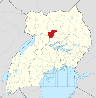
Pader is a town in Pader District in the Northern Region of Uganda. The town is administered by the Pader Town Council, an urban local government. It is the largest metropolitan area in the district and the site of the district headquarters.

<span class="mw-page-title-main">Oyam District</span> District in Northern Uganda, Uganda

Oyam District is a district in Northern Uganda. Like most Ugandan districts, it is named after its 'chief town', Oyam, where the district headquarters are located.

<span class="mw-page-title-main">Amuru District</span> District in Northern Uganda, Uganda

Amuru District is a district in Northern Uganda. Like most Ugandan districts, it is named after its 'chief town', Amuru, where the district headquarters are located.

<span class="mw-page-title-main">Abim District</span> District in Uganda

Abim District is a district in Northern Uganda. It is named after its 'chief town', Abim, where the district headquarters are located.

<span class="mw-page-title-main">Lamwo District</span> District in Northern Region of Uganda, Uganda

Lamwo District is a district in the Northern Region of Uganda. The town of Lamwo is the site of the district headquarters.

<span class="mw-page-title-main">Agago District</span> District in Northern Uganda, Uganda

The Agago District is a Ugandan district located in the Northen Region of Uganda.

Agago is a town in the Northern Region of Uganda. It is the chief political, administrative, and commercial center of the Agago District.

Kalongo is a town in the Northern Region of Uganda. It is one of the urban centers in Agago District.

Kalongo Hospital, also known as Dr. Ambrosoli Memorial Hospital, is a hospital in Northern Uganda. It is a private, community hospital, serving the town of Kalongo and surrounding areas of Agago District, Pader District and parts of Kitgum District.

St. Joseph's Hospital Kitgum (SJHK), is a hospital in the Northern Region of Uganda. It is a private, non-profit, community hospital, serving the town of Kitgum and surrounding areas of Kitgum District, Lamwo District and parts of the Republic of South Sudan. In addition, the hospital receives many patients from Kotido District, Abim District, Moroto District, Agago District and Pader District.

Kitgum Hospital, is a government-owned hospital in Northern Uganda. It serves as the district hospital for Kitgum District.

<span class="mw-page-title-main">Acholi people</span> Ethnic group of South Sudan and Northern Uganda

The Acholi people are a Nilotic ethnic group of Luo peoples, found in Magwi County in South Sudan and Northern Uganda, including the districts of Agago, Amuru, Gulu, Kitgum, Nwoya, Lamwo, Pader and Omoro District. The Acholi were estimated to number 2.3 million people and over 45,000 more were living in South Sudan in 2000.

<span class="mw-page-title-main">Aruu Falls</span> Waterfall in Uganda

Aruu Falls, also known as Aruu Falls Camspite, are natural waterfalls located in Northern Uganda along the Gulu Kitgum highway in Pader District. The falls are 47 kilometers away from Gulu, 57 kilometers away from Kitgum, and 386 kilometers away from Kampala, the capital city of Uganda.

References

  1. Uganda District Map
  2. "Road Distance Between Gulu And Pader With Map". Globefeed.com. Retrieved 22 May 2014.
  3. "Estimated Population of Pader District In 1991, 2002 & 2012". Citypopulation.de. Retrieved 22 May 2014.
  4. Owot, Robert (30 March 2014). "Pader: Where Cotton Is Still A Major Earner". Daily Monitor . Retrieved 22 May 2014.