Pader, Uganda

Last updated
Pader
Uganda location map.svg
Red pog.svg
Pader
Map of Uganda showing the location of Pader
Coordinates: 02°52′40″N33°05′06″E / 2.87778°N 33.08500°E / 2.87778; 33.08500
CountryFlag of Uganda.svg  Uganda
Region Northern Uganda
Sub-region Acholi sub-region
District Pader District
Elevation
1,020 m (3,350 ft)
Population
 (2014 Census)
  Total14,080 [1]
Time zone UTC+3 (EAT)

Pader is a town in Pader District in the Northern Region of Uganda. The town is administered by the Pader Town Council, an urban local government. It is the largest metropolitan area in the district and the site of the district headquarters. [2]

Contents

Location

Pader is bordered by Pajule to the north, Parabong to the northeast, Lira Palwo to the east, Puranga to the south, and Awere to the west. The town is approximately 60 kilometres (37 mi), by road, southeast of Kitgum, the nearest large town. [3] Pader is approximately 133 kilometres (83 mi), by road, east of Gulu, the largest city in the Northern Region of Uganda. [4] The coordinates of the town are 2°52'43.0"N, 33°05'06.0"E (Latitude:2.8786; Longitude:33.0850). [5]

Overview

Pader sprang up in 2000, the same year that Pader District was formed. The town soon became a center of foreign relief agencies assisting the civilian population affected by the Lord's Resistance Army insurgency. While over US$2 million has been poured into this effort, there is little to show for it because of corruption, poor planning, poor implementation, poor follow up, poor management, lack of accountability, and a hands-off approach by many of the donor agencies. [6] [7]

Population

Women of Pader pounding sorghum Pader Women.jpg
Women of Pader pounding sorghum

The 2002 national census estimated the population of the town at about 8,700. The Uganda Bureau of Statistics (UBOS) estimated the population at 12,800 in 2010. In 2011, UBOS estimated the mid-year population at 13,500. [8] The 2014 census enumerated the population of the town at 14,080. [1]

In 2015, the population of the town was projected at 13,500. In 2020, the mid-year population of Pader Town was projected at 14,800. It was calculated that the population of the town increased at an average annual rate of 1.9 percent, between 2015 and 2020. [9]

Historical population
YearPop.±%
20028,700    
201012,800+47.1%
201114,500+13.3%
201414,080−2.9%
201513,500−4.1%
202014,800+9.6%
source: [1] [8] [9]

Points of interest

The following additional points of interest lie within or near the town of Pader:

See also

Related Research Articles

<span class="mw-page-title-main">Moroto Town</span> Place in Northern Region, Uganda

Moroto is a town in Moroto District in the Northern Region of Uganda. The town serves as the location of the district headquarters.

<span class="mw-page-title-main">Apac</span> Ugandan town

Apac is a town in Apac District in the Northern Region of Uganda. It is the 'chief town' of the district and the district headquarters are located there. The district is named after the town.

<span class="mw-page-title-main">Adjumani</span> Ugandan town

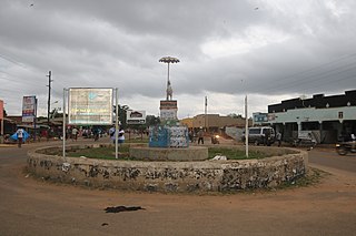
Adjumani is a town in the Northern Region of Uganda. It is the main municipal, administrative, and commercial centre of Adjumani District. The district is named after the town.

Yumbe is a town in the Northern Region of Uganda. It is the district headquarters of Yumbe District.

Moyo, is the main municipal, administrative, and commercial center of Moyo District in the Northern Region of Uganda. The district headquarters are located here.

Pakwach is a town in the Northern Region of Uganda. It is the main commercial, political and administrative center of Pakwach District. In the 19th century the town came under brief occupation by the Ottoman tributary of the Khedivate of Egypt, as part of Hatt-ı Üstuva (Equatoria) Vilayet.

Nebbi is a town in the Nebbi District of the Northern Region of Uganda. It is the site of the district headquarters.

Butaleja is a town in Eastern Region of Uganda. It is the main municipal, administrative and commercial center of Butaleja District and the district headquarters are located there. The district is named after the town.

Wobulenzi is a municipality in Katikamu sub-county, in Luweero District in the Central Region of Uganda.

Busolwe is a town in the Eastern Region of Uganda. It is one of the two municipalities in Butaleja District, the other being Butaleja.

Abim is a town in the Northern Region of Uganda. It is the chief municipal, administrative, and commercial center of Abim District. The district is named after the town.

<span class="mw-page-title-main">Agago District</span> District in Northern Uganda, Uganda

The Agago District is a Ugandan district located in the Northen Region of Uganda.

Agago is a town in the Northern Region of Uganda. It is the chief political, administrative, and commercial center of the Agago District.

Alebtong, is a town in the Northern Region of Uganda. It is the chief municipal, administrative, and commercial centre of Alebtong District. The district is named after the town.

Kalongo is a town in the Northern Region of Uganda. It is one of the urban centers in Agago District.

Kalongo Hospital, also known as Dr. Ambrosoli Memorial Hospital, is a hospital in Northern Uganda. It is a private, community hospital, serving the town of Kalongo and surrounding areas of Agago District, Pader District and parts of Kitgum District.

Amuru is a town in the Northern Region of Uganda. It is the main municipal, administrative, and commercial centre of Amuru District.

The Acholibur–Gulu–Olwiyo Road is a road in the Northern Region of Uganda, connecting the town of Acholibur to the city of Gulu and the town of Olwiyo.

Rwekunye is a settlement in Kiryandongo District in the Western Region of Uganda.

References

  1. 1 2 3 UBOS (27 August 2014). "The Population of The Regions of the Republic of Uganda And All Cities And Towns of More Than 15,000 Inhabitants". Citypopulation.de Quoting Uganda Bureau of Statistics (UBOS). Retrieved 12 December 2015.
  2. ReliefWeb (11 November 2004). "Uganda: Tough life for IDPs in Pader camp". ReliefWeb International . Retrieved 5 January 2020.
  3. Google (5 January 2021). "Distance Between Pader, Uganda And Kitgum, Uganda With Map" (Map). Google Maps . Google. Retrieved 5 January 2021.
  4. Google (5 January 2021). "Road Distance Between Gulu, Uganda And Pader, Uganda" (Map). Google Maps . Google. Retrieved 5 January 2021.
  5. Google (5 January 2021). "Location of Pader, Northern Region, Uganda" (Map). Google Maps . Google. Retrieved 5 January 2021.
  6. Ann Mugisa, and Raymond Baguma (2 November 2012). "OPM Fraud: More Donors Cut Aid". New Vision . Retrieved 4 June 2014.
  7. Butagira, Tabu (9 January 2013). "Government Raids Treasury to Refund Stolen Aid". Daily Monitor . Retrieved 4 June 2014.
  8. 1 2 Uganda Bureau of Statistics (June 2011). "Estimated Population of Pader In 2002, 2010 And 2011". Uganda Bureau of Statistics . Archived from the original (Archived from the original on 11 April 2019) on 11 April 2019. Retrieved 5 August 2022.
  9. 1 2 Citypopulation.de (14 June 2020). "The population development of Pader Town Council as well as related information and services" (Citypopulation.de Quoting Uganda Bureau of Statistics). Citypopulation.de. Retrieved 5 August 2022.
  10. Google (5 August 2022). "Distance Between Pader, Uganda And Kalongo, Uganda" (Map). Google Maps . Google. Retrieved 5 August 2022.

2°52′43″N33°05′06″E / 2.87861°N 33.08500°E / 2.87861; 33.08500