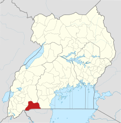
Isingiro District

Last updated

Isingiro District
Isingiro District in Uganda.svg
District location in Uganda
Coordinates: 00°50′S30°50′E / 0.833°S 30.833°E / -0.833; 30.833
CountryFlag of Uganda.svg  Uganda
Region Western Uganda
Sub-region Ankole sub-region
Capital Isingiro
Area
  Total2,655.6 km2 (1,025.3 sq mi)
Population
 (2012 Estimate)
  Total420,200
  Density158.2/km2 (410/sq mi)
Time zone UTC+3 (EAT)
Area code 062
Website www.isingiro.go.ug

Isingiro District is a district in the Western Region of Uganda. The town of Isingiro is the district's main municipal, administrative, and commercial center.

Contents

Location

Isingiro District is bordered by Kiruhura District to the north, Rakai District to the east, Tanzania to the south, Ntungamo District to the west, and Mbarara District to the north-west. The town of Isingiro is approximately 35 kilometres (22 mi) south-east of the city of Mbarara, the main metropolitan area in the Ankole sub-region. [1]

Population

The 2014 national housing and population census estimated the population of Isingiro District at 486,360. In 2002, the population was recorded at approximately 316,000, while the 1991 national census estimated the population at 226,400. [2]

Prominent people

Prominent people from the district include:

See also

Small traders transport charcoal on a rickety boat across River Kagera in Kajaho, Isingiro District on the Uganda-Tanzania border. Informal Cross-border Trade.jpg
Small traders transport charcoal on a rickety boat across River Kagera in Kajaho, Isingiro District on the Uganda-Tanzania border.

Related Research Articles

<span class="mw-page-title-main">Ntungamo District</span> District in Western Uganda, Uganda

Ntungamo District is a district in Western Uganda. Like most Ugandan districts, it is named after its 'chief town', Ntungamo, the location of the district headquarters. Ntungamo was elevated to a district on 5th May 1993.

<span class="mw-page-title-main">Mbarara district</span> District in Western Uganda, Uganda

Mbarara District is a district in South Western Uganda. In 2019, the Ugandan Cabinet approved part of Mbarara District, the then-Mbarara municipality, to be upgraded to city status effective July 2020.

<span class="mw-page-title-main">Rakai District</span> District in Central Region of Uganda, Uganda

Rakai District is a district in the Central Region of Uganda. The town of Rakai is the site of the district's headquarters.

<span class="mw-page-title-main">Katakwi District</span> District in Eastern Uganda, Uganda

Katakwi District is a district in the Eastern Region of Uganda. The town of Katakwi is the site of the district headquarters.

<span class="mw-page-title-main">Bushenyi District</span> District in Western Uganda, Uganda

Bushenyi District is a district in Western Uganda. Like many other Ugandan districts, it is named after its chief town, Bushenyi, where the district headquarters are located.

<span class="mw-page-title-main">Kabale District</span> District in Western Region, Uganda

Kabale District is a district in the Western Region of Uganda. Kabale hosts the district headquarters. It was originally part of Kigezi District, before the districts of Rukungiri, Kanungu, Kisoro, Rubanda and Rukiga were excised to form separate districts. Kabale is sometimes nicknamed "Kastone" as in the local language Rukiga, a "kabale" is a small stone.

<span class="mw-page-title-main">Kabale</span> Place in Western Region of Uganda, Uganda

Kabale is a town in the Western Region of Uganda. It is the chief town of Kabale District, and the district headquarters are located there.

<span class="mw-page-title-main">Ntungamo</span> Place in Uganda

Ntungamo is a town in the Western Region of Uganda. It is the largest town in Ntungamo District and the site of the district headquarters.

<span class="mw-page-title-main">Ibanda District</span> District in Western Region, Uganda

Ibanda District is a district in the Western Region of Uganda. The town of Ibanda is the site of the district headquarters.

<span class="mw-page-title-main">Amuria District</span> District in Eastern Uganda, Uganda

Amuria District is a district in the Eastern Region of Uganda. The town of Amuria serves as the district headquarters.

<span class="mw-page-title-main">Kiruhura District</span> District in Western Region, Uganda

Kiruhura District is a district in the Western Region of Uganda. The town of Rushere is the site of the district headquarters.

<span class="mw-page-title-main">Bright Rwamirama</span> Ugandan politician

Bright Kanyontore Rwamirama is a Ugandan politician, Member of Parliament and retired army officer. He is the minister for animal industry in the Ugandan cabinet. He was appointed to that position on 1 June 2006. In the cabinet reshuffle of 16 February 2009, 27 May 2011, and 1 March 2015, he retained his cabinet post. He also serves as the elected Member of Parliament representing Isingiro County North, Isingiro District. He has served in that capacity continuously since 2001. He defeated Posiono Mugyenyi in the 2021 general election.

Isingiro is a town in the Western Region of Uganda. It is the main municipal, administrative, and commercial center of Isingiro District and the site of the district's headquarters.

<span class="mw-page-title-main">Lamwo District</span> District in Northern Region of Uganda, Uganda

Lamwo District is a district in the Northern Region of Uganda. The town of Lamwo is the site of the district headquarters.

<span class="mw-page-title-main">Rubirizi District</span> District in Western Uganda, Uganda

Rubirizi District is a district in Western Uganda. Like most Ugandan districts, the district is named after its 'chief town', Rubirizi, where the district headquarters are located.

<span class="mw-page-title-main">Buhweju District</span> District in Western Uganda, Uganda

Buhweju District is a district in Western Uganda. It is one of the districts that constitute the Ankole sub-region. Its 'chief town', is Nsiika.

<span class="mw-page-title-main">Mitooma District</span> District in Uganda

itooma District is a district in Western Uganda. It is named after its main municipal, administrative and commercial center, Mitooma.

<span class="mw-page-title-main">Sheema District</span> District in Western Uganda, Uganda

Sheema District is a district in Western Uganda.

<span class="mw-page-title-main">Kazo District</span> District in Western, Uganda

Kazo is a district in Uganda's Western Region. It is located approximately 200 square kilometres (77 sq mi) west of Uganda's capital Kampala. It covers an area of 1,556 square kilometres (601 sq mi) and recorded a population of 177,054 in the 2014 Ugandan census. The capital of the district is the town of Kazo.

Rugaaga is a town in Isingiro District in the Western Region of Uganda.

References

  1. "Road Distance Between Mbarara And Isingiro With Map". Globefeed.com. Retrieved 21 May 2014.
  2. "Estimated Population of Isingiro District In 1991, 2002 & 2014". Citypopulation.de. Retrieved 18 September 2016.
  3. Independent, The (17 February 2020). "Museveni, Besigye mourn Maj. Gen Benon Biraro". The Independent Uganda. Retrieved 5 March 2022.