Bulambuli District

Last updated

Bulambuli District
Bulambuli District in Uganda.svg
District location in Uganda
Coordinates: 01°22′N34°09′E / 1.367°N 34.150°E / 1.367; 34.150
CountryFlag of Uganda.svg  Uganda
Region Eastern Region, Uganda
Sub-division Bugisu sub-region
Capital Bulambuli
Area
  Land651.8 km2 (251.7 sq mi)
Population
 (2012 Estimate)
  Total125,400
  Density192.4/km2 (498/sq mi)
Time zone UTC+3 (EAT)
Website www.bulambuli.go.ug

Bulambuli District is a district in Eastern Uganda. The district is named after 'chief town', Bulambuli, where the district headquarters are located.

Contents

Location

Bulambuli District is bordered by Nakapiripirit District to the north, Kapchorwa District to the east, Sironko District to the south and Bukedea District to the west. [1] Bulambuli, the district headquarters, is located approximately 32 kilometres (20 mi), by road, northeast of Mbale, the largest city in the sub-region. [2] The coordinates of the district are:01 22N, 34 09E.

Overview

Bulambuli District was created by Act of the Ugandan Parliament, in 2009, and became operational on 1 July 2010. Prior to that, the district was part of Sironko District. The terrain in the southern part of the district is mountainous and prone to flash flooding. [3] The northern part of the district, closer to Nakapiripirit District, is more dry and is prone to clean water shortages. [4]

Population

In 1991, the national population census estimated the district population at about 64,600. The next national census in 2002 estimated the population of the district at about 97,300. In 2012, the population of Bulambuli District was estimated at 125,400. [5]

Economic activities

Subsistence agriculture and animal husbandry are the two main economic activities in the district. Crops grown include:

Prominent people

Some of the prominent people from the district include the following:

Mabonga Jesse Guild President Kumi University 2022 DAVID KATENYA, Current MP Bulambuli

See also

Related Research Articles

<span class="mw-page-title-main">Mbale District</span> District in Eastern Uganda, Uganda

Mbale District is a district in Eastern Uganda. It is named after the largest city in the district, Mbale, which also serves as the main administrative and commercial center in the sub-region.

<span class="mw-page-title-main">Moroto District</span> District in Northern Region of Uganda, Uganda

Moroto District is a district in the Northern Region of Uganda. The town of Moroto is the site of the district headquarters.

<span class="mw-page-title-main">Nakapiripirit District</span> District in Northern Uganda, Uganda

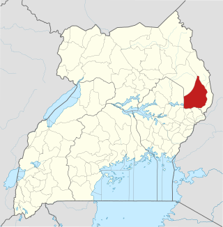
Nakapiripirit District is a district in Northern Uganda. Like many Ugandan districts, it is named after its 'chief town', Nakapiripirit, where the district headquarters are located.

<span class="mw-page-title-main">Kapchorwa District</span> District in Eastern Uganda, Uganda

Kapchorwa District is a district in the Eastern Region of Uganda. The town of Kapchorwa is the district's main municipal, administrative, and commercial center, and is the site of the district headquarters. It is also the home district of Stephen Kiprotich, the men's marathon gold medalist at the 2012 Summer Olympics, and Joshua Cheptegei, the men's 5,000 m gold medalist at the 2021 Summer Olympics in Tokyo.

<span class="mw-page-title-main">Sironko District</span> District in Uganda

Sironko District is a district in the Eastern Region of Uganda. The district was created in 2000 and had previously been part of Mbale District. Sironko is the main commercial town in the district.

<span class="mw-page-title-main">Soroti</span> Ugandan town

Soroti is a city in Eastern Region of Uganda. It is the main city, commercial, and administrative center in Soroti District, one of the nine administrative districts in the Teso sub-region. Soroti city was immediately approved for operationalization ahead of schedule by the Parliament of Uganda in the Financial Year 2020/2021.

<span class="mw-page-title-main">Mbale</span> Place in Eastern Uganda, Uganda

Mbale is a city in the Eastern Region of Uganda. It is the main municipal, administrative, and commercial center of Mbale District and the surrounding sub-region.

<span class="mw-page-title-main">Moroto Town</span> Place in Northern Region, Uganda

Moroto is a town in Moroto District in the Northern Region of Uganda. The town serves as the location of the district headquarters.

Sironko is the largest metropolitan area in Sironko District of the Eastern Region of Uganda and the site of the district headquarters.

Nakapiripirit is a town in the Nakapiripirit District of the Northern Region of Uganda. It is the seat of the district headquarters. As an administrative unit of the district, it is one of the eight sub-counties in the district.

<span class="mw-page-title-main">Butaleja District</span> District in Eastern Uganda, Uganda

Butaleja District is a district in Eastern Uganda. It is named after its 'chief town', Butaleja, where the district headquarters are located.

<span class="mw-page-title-main">Bududa District</span> District in Eastern Uganda, Uganda

Bududa District is a district in the Eastern Region of Uganda. Bududa is the chief town of the district.

<span class="mw-page-title-main">Bukedea District</span> District in Eastern Region of Uganda, Uganda

Bukedea District is a district in the Eastern Region of Uganda. The town of Bukedea is the site of the district headquarters.

Budadiri is a town in the Eastern Region of Uganda. It is one of the urban centers in Sironko District.

<span class="mw-page-title-main">Kween District</span> District in Uganda

Kween District is a district in Eastern Uganda. The district headquarters are located at Binyiny, one of the two town councils in the district.

Bulambuli is a town in Eastern Uganda. It is the main municipal, administrative and commercial center of Bulambuli District. The district is named after the town.

Kibuku is a town in Eastern Uganda. It is the chief municipal, administrative and commercial center of Kibuku District.

Bugisu sub-region is a region in Eastern Uganda that consists of the following districts:

Muyembe–Nakapiripirit Road is a road in the Eastern and Northern regions of Uganda. The road connects the towns of Muyembe in Bulambuli District, to the town of Nakapiripirit in Nakapiripirit District.

References

  1. Uganda District Map
  2. "Distance Between Mbale And Bulambuli With Map". Globefeed.com. Retrieved 18 May 2014.
  3. Edyegu, Daniel (6 November 2011). "Floods Hit Eastern Uganda". New Vision. Archived from the original on 18 May 2014. Retrieved 18 May 2014.
  4. Vision, Reporter (8 December 2010). "Museveni Probes Bulambuli Water Projects". New Vision. Archived from the original on 18 May 2014. Retrieved 18 May 2014.
  5. "Estimated Population of Bulambuli District In 1991, 2002 & 2012". Citypopulation.de. Retrieved 18 May 2014.