Kabarole District is a district in Western Uganda. Kabarole District is part of the Tooro Kingdom. Its main town was Fort Portal before 1 July 2020 when it was elevated to a city, separating it from Kabarole district. The new Kabarole district seat is proporsed in Busoro Town Council. Kabarole remains with only one county (Burahya). Bunyangabu county was curved out to form Bunyangabu district in 2017. Fort Portal Municipality constituency became Fort Portal City in 2020 with an independent local Government.

Mbarara District is a district in South Western Uganda. In 2019, the Ugandan Cabinet approved part of Mbarara District, the then-Mbarara municipality, to be upgraded to city status effective July 2020.

Apac District is a district in the Northern Region of Uganda. The Town of Apac hosts the district headquarters.
Kamwenge District is a district in Western Uganda. It is named after its 'chief town', Kamwenge, where the district headquarters are located. Kamwenge District is part of the Kingdom of Toro, one of the ancient traditional monarchies in Uganda. The kingdom is coterminous with Toro sub-region. The districts that constitute the sub-region are: (a) Bunyangabu District (b) Kabarole District (c) Kamwenge District (d) Kyegegwa District (e) Kitagwenda District and (f) Kyenjojo District.

Masindi District is a district in Western Uganda. Like many other Ugandan districts, it is named after its 'chief town' of Masindi, the location of the district headquarters.

Queen Elizabeth National Park is a national park in the Western Region of Uganda.

Kasese is a town in the Western Region of Uganda. It is the capital of Kasese District. Kasese is also the largest town in the Rwenzururu region. In 2020 it had an estimated population 115,400. It lies north of Lake George and east of Rwenzori Mountains.

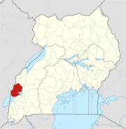
Bundibugyo is a town in the Western Region of Uganda. It is the 'chief town' of Bundibugyo District and the district headquarters are located there.

Rwenzururu is a subnational kingdom in western Uganda, located in the Rwenzori Mountains on the border with the Democratic Republic of the Congo. It includes the districts of Bundibugyo, Kasese and Ntoroko. Rwenzururu is also the name given to the region the kingdom is located in.
Amolatar District is a district in Northern Uganda. Like many other Ugandan districts, it is named after its main municipal and administrative centre, Amolatar Town.
Mpondwe is a town in the Western Region of Uganda.

Hima is a town in the Western Region of Uganda. It is an industrial town, involved primarily in the manufacture of cement.
Charles Wesley Mumbere, known by his royal title Irema-Ngoma I, is the king of Rwenzururu, a subnational kingdom within Uganda. Mumbere was arrested in December 2016 after the clashes in the kingdom's capital of Kasese, and has since been in prison awaiting trial.
Mweya is a location in the Western Region of Uganda.

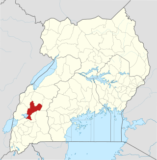
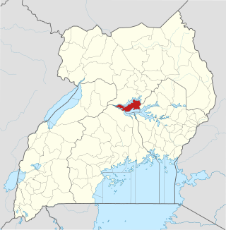
Rubirizi District is a district in Western Uganda. Like most Ugandan districts, the district is named after its 'chief town', Rubirizi, where the district headquarters are located.

Ntoroko District is a district in the Western Region of Uganda. The district headquarters are in the Kibbuuku town council. It is the second least populated district in Uganda.
The Songora or Shongora are a traditionally pastoralist people of the Great Lakes region of Central Africa located in Western Region, Uganda and Eastern Democratic Republic of the Congo. They have distinctive customs and speak Rusongora, a Bantu language that is similar to Runyankole and Runyoro. The Basongora population in Uganda was reported at numbering 15,897 people in the 2014 census. Although various community estimates put their population at around 40,000 and 50,000 people. Some Basongora also live in Eastern Congo.
Ntoroko is a town officially known as Kanara Town Council in Ntoroko District Western Uganda. It is one of the four town councils of Ntoroko District the others being Karugutu, Rwebisengo and Kibuku Town Council. Ntoroko is the largest fishing town on the southern Mwitanzige shore. Its located on the Ntoroko bay extending from Kanara Fishing village to the western half of the Ntoroko Peninsula. The peninsular also separates Ntoroko bay from the Muziizi Bay. By Road, Ntoroko town is approximately 84 KM Northwest of Fort Portal City, the regional Capital and approximately 79 KM via Karugutu, north of Kibuku Town Council the District Capital. Ntoroko/Kanara Town Council is settled by many ethnicities, the largest being; Rwenzori Peoples; Batooro/Batuku, Bakonzo, Bamba, Babwisi. Bunyoro peoples; Bagangaizi, Bagungu and other Banyoro. Alur, Lendu and Ngite. Congolese of the Western Mwitanzige shore; Alur, Gegere, Nande, to mention but a few.
Bugoye is a small town in Western Uganda.
Kitagwenda District is a district in Western Uganda. The district is named after Kitagwenda County, which is coterminous with the district.