Hima, Uganda

Last updated
Hima
Uganda location map.svg
Red pog.svg
Hima
Location in Uganda
Coordinates: 00°17′26″N30°10′39″E / 0.29056°N 30.17750°E / 0.29056; 30.17750
Country Flag of Uganda.svg Uganda
Region Western Uganda
Sub-region Rwenzururu sub-region
District Kasese District
Elevation
3,222 ft (982 m)
Population
 (2019 Estimate)
  Total14,700
Climate Aw

Hima is a town in the Western Region of Uganda. It is an industrial town, involved primarily in the manufacture of cement. [1]

Contents

Location

Hima is located in Kitswamba Parish, Busongora County, Kasese District, in Western Uganda. The town lies along the Fort Portal–Kasese–Mpondwe Road, approximately 23.5 kilometres (15 mi), by road, northeast of Kasese, the largest town in the Rwenzururu sub-region. [2] This is approximately 57 kilometres (35 mi), by road, southwest of Fort Portal, the nearest large city. [3] The coordinates of the town are:0°17'26.0"N, 30°10'39.0"E (Latitude:0.290556; 30.177500). [4] Hima sits at an average elevation of 982 metres (3,222 ft) above mean sea level. [5]

Population

The 2002, the national population census gave the population of Hima at 7,075 people. In 2014, the national population census and household survey, enumerated the towns population at 13,135. The Uganda Bureau of Statistics (UBOS), estimated the mid-year population in 2019, at 14,700. [6] The table below illustrates the same data in a tabular format.

YearPopulation
20027,075 [6]
201413,135 [6]
201914,700 [6]

Economy

The town is the headquarters of Hima Cement Limited, the second-largest manufacturer of cement in Uganda, producing about 1,700,000 tonnes (1,873,929 tons) annually. [7] Hima Cement is a subsidiary of LafargeHolcim, a Swiss conglomerate, that manufactures building materials, with subsidiaries in about 80 countries around the globe, with about 72,500 employees. [7] Hima Cement is the largest employer in town, with 320 permanent employees and about 200 contractors at the company headquarters. The company maintains two production lines at Hima, with combined production capacity at this site of 850,000 tonnes (936,965 tons) of cement powder. The company maintains another factory at Tororo, in the Eastern Region of Uganda, with equivalent production capacity. [1] [8]

Transport

The Fort Portal–Kasese–Mpondwe Road passes through the town in a north to south direction. The nearest airport is Kasese Airport, located approximately 23.5 kilometres (15 mi), south of town. [2]

See also

Related Research Articles

Kasese District District in Uganda

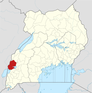
Kasese District is a district in Western Uganda. Like most other Ugandan districts, the town of Kasese is the site of the district headquarters.

Kasese Place in Western Region, Uganda

Kasese is a town north of Lake George in the Western Region of Uganda. It originally grew around the copper mine at Kilembe, while attention later turned to cobalt mining. It is the chief town of Kasese District, and the district headquarters are located there. Kasese is also the largest town in the Rwenzururu region. Charles Mumbere, the Omusinga of Rwenzururu, maintains a palace in the town.

Holy Family Virika Hospital, commonly referred to as Virika Hospital, is a private, community hospital, in Fort Portal, Kabarole District, Western Uganda.

Mpondwe Place in Uganda

Mpondwe is a town in the Western Region of Uganda.

Rwimi Place in Bunyangabu District

Rwimi is a town in Bunyangabu District in the Western Region of Uganda.

Mweya Place in Uganda

Mweya is a location in the Western Region of Uganda.

Tororo Cement Limited (TCL), a Ugandan company, is one of the largest manufacturers of construction materials in East Africa.

Hima Cement Limited (HCL) is a cement manufacturer in Uganda. It is a subsidiary of LafargeHolcim, a building materials manufacturer headquartered in Switzerland, with subsidiaries in over 80 countries.

Mubuku Place in Western Uganda, Uganda

Mubuku is a settlement in Uganda.

Moroto Cement Limited (MCL), whose full name is Moroto Cement Industries Limited, is a manufacturer of cement in Uganda with approximately 3000 tonnes per day clinker capacity.

Rwimi Hydroelectric Power Station Dam in Rwimi, Bunyangabu District

Rwimi Hydroelectric Power Station, also Rwimi Power Station, is an operational 5.54 megawatts (7,430 hp) hydroelectric power station in the Western Region of Uganda.

Bugoye Place in Western Uganda, Uganda

Bugoye is a small town in Western Uganda.

Kilembe, Uganda Place in Western Region, Uganda

Kilembe is a community in Kasese District, in the Western Region of Uganda.

The Fort Portal–Kasese–Mpondwe Road also Fort Portal–Mpondwe Road, is a road in the Western Region of Uganda, connecting the towns of Fort Portal, Hima, Kasese, Kikorongo and the border town of Mpondwe.

Kikorongo Place in Uganda

Kikorongo, also Kikorongo Junctiom, is a settlement in Kasese District, in the Western Region of Uganda.

Kikorongo–Ishaka Road is a road in the Western Region of Uganda, connecting the towns of Kikorongo in Kasese District with Ishaka in Bushenyi District.

Kibiito Place in Uganda

Kibiito is a town in the Western Region of Uganda. It is the chief administrative center of Bunyangabu District, and the district headquarters are located there.

Rubona, Bunyangabu Place in Western Uganda, Uganda

Rubona is a town in the Western Region of Uganda.

Nkenda Place in Western Uganda, Uganda

Nkenda is a hill in Kasese District in the Western Region of Uganda. The name is also applied to the settlement at the bottom of that hill.

Kasusu Neighborhood in Uganda

Kasusu is a neighborhood in the city of Fort Portal, the largest urban center in Kabarole District, in the Western Region of Uganda.

References

  1. 1 2 Alex Ashaba (27 May 2020). "Hima: Industrial Town Ideal For Housing, Business Start-Ups". Daily Monitor . Kampala. Retrieved 29 May 2020.
  2. 1 2 Google (29 May 2020). "Distance Between Kasese and Hima" (Map). Google Maps . Google. Retrieved 29 May 2020.
  3. Google (29 May 2020). "Distance Between Fort Portal And Hima" (Map). Google Maps . Google. Retrieved 29 May 2020.
  4. Google (5 July 2015). "Location of Hima At Google Maps" (Map). Google Maps . Google. Retrieved 5 July 2015.
  5. Mapcarta (29 May 2020). "Elevation of Hima Town Council, Kasese District, Uganda". Mapcarta.com. Retrieved 29 May 2020.
  6. 1 2 3 4 Uganda Bureau of Statistics (11 March 2019). "Republic of Uganda: The population of all Ugandian cities and towns with more than 15,000 inhabitants according to census results and latest official projections: Hima". Citypopulation.de. Retrieved 29 May 2020.
  7. 1 2 "Hima Cement Uganda: About Us". Hima, Uganda: Lafarge.co.ug. 29 May 2020. Retrieved 29 May 2020.
  8. Hima Cement (29 May 2020). "History and Background: Production Capacity and Hima Employees". Hima, Uganda: Hima Cement Limited. Retrieved 29 May 2020.

Coordinates: 00°17′21″N30°10′41″E / 0.28917°N 30.17806°E / 0.28917; 30.17806