Kasese began as a small trading post in the early 20th century. Its growth was significantly stimulated in the 1950s with two major developments: the establishment of the Kilembe Mines for copper and cobalt extraction, and the construction of the western extension of the Uganda Railway to the area, creating a transport hub.[6] The town was planned and built to support the mining industry, which attracted a large workforce and spurred commercial activity.
During the mid-20th century, Kasese became the epicentre of the Rwenzururu movement, a political and armed struggle by the Bakonzo and Amba people seeking secession from the Tooro Kingdom. The town and surrounding district were the heartland of the self-declared Rwenzururu Kingdom led by Isaya Mukirania.[7]
Kasese was granted township status and later became a municipality.
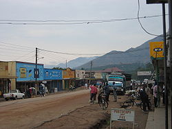
Geography and Location
Kasese is situated at the western end of the Uganda-Congo border, just north of Lake George and south of the Rwenzori Mountains. The city's coordinates are 0°11'12.0"N, 30°05'17.0"E (Latitude: 0.186667; Longitude: 30.088050).
It is approximately 360 kilometres (224mi) by road, west of Kampala, Uganda's capital. The city's location makes it a strategic hub for trade with the eastern Democratic Republic of the Congo, with the border town of Mpondwe located about 60 kilometres (37mi) to the south-west.
Due to its location at the foot of the Rwenzori Mountains, Kasese is highly susceptible to severe flooding. The Nyamwamba River, which flows down from the mountains and through the city, frequently bursts its banks during heavy rainy seasons. This is caused by a combination of factors, including the steep terrain, deforestation, and the effects of climate change on the mountain's glaciers.[9] Major floods, such as those in 2013, 2020, and 2022, have caused widespread destruction, displacing thousands of residents, destroying infrastructure like bridges and buildings, and resulting in loss of life.[10]
Population
According to the 2014 national census, the population of Kasese Municipality was 101,057.[4] The Uganda Bureau of Statistics (UBOS) estimated the mid-year population in 2020 to be approximately 115,400.[11] The population is ethnically diverse due to historical labour migration for the mines, but the majority are of the Bakonzo ethnic group.
Economy
The economy of Kasese municipality is driven by several key sectors:
Mining: Historically, the city's economy was dominated by Kilembe Mines, one of Africa's largest copper and cobalt producers. While large-scale mining ceased in the 1980s, the Kasese Cobalt Company Limited (KCCL) later processed the stockpile of cobalt-rich tailings.[12]Hima Cement Limited, located in the nearby town of Hima, is also a major employer in the region.
Agriculture: The surrounding region is fertile, supporting the cultivation of crops such as coffee, cotton, and various fruits and staple foods, which are traded in the city's markets.
Trade: Its proximity to the Democratic Republic of the Congo makes Kasese an important centre for cross-border trade.
↑ Stephens, A. J. (1955). "THE KILEMBE MINE". The Uganda Journal. 19 (1): 85–86. Retrieved 3 July 2025.
↑ Prunier, Gérard (2009). Africa's World War: Congo, the Rwandan Genocide, and the Making of a Continental Catastrophe. Oxford University Press. p.82. ISBN978-0-19-970583-2.
This page is based on this Wikipedia article Text is available under the CC BY-SA 4.0 license; additional terms may apply. Images, videos and audio are available under their respective licenses.