Kabarole District is a district in Western Uganda. Kabarole District is part of the Tooro Kingdom. Its main town was Fort Portal before 1 July 2020 when it was elevated to a city, separating it from Kabarole district. The new Kabarole district seat is proporsed in Busoro Town Council. Kabarole remains with only one county (Burahya). Bunyangabu county was curved out to form Bunyangabu district in 2017. Fort Portal Municipality constituency became Fort Portal City in 2020 with an independent local Government.

Kamuli District is a district in the Eastern Region of Uganda. The town of Kamuli is the site of the district headquarters.
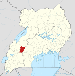
Kamwenge District is a district in Western Uganda. It is named after its 'chief town', Kamwenge, where the district headquarters are located. Kamwenge District is part of the Kingdom of Toro, one of the ancient traditional monarchies in Uganda. The kingdom is coterminous with Toro sub-region. The districts that constitute the sub-region are: (a) Bunyangabu District (b) Kabarole District (c) Kamwenge District (d) Kyegegwa District (e) Kitagwenda District and (f) Kyenjojo District.

Kasese District is a district in Western Uganda. Like most other Ugandan districts, it is named after its chief town and district headquarters, the town of Kasese.

Kibaale District, is a district in the Western Region of Uganda. The district headquarters are in the town of Kibaale.

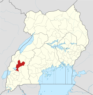
Kyenjojo District is a district in the Western Region of Uganda. Kyenjojo town is the site of the district headquarters.

Fort Portal or Kabarole is a city located in the Western Region of Uganda. It is the seat of both Kabarole District and historically of the Tooro Kingdom.
Mubende is a town in the Central Region of Uganda. It is the main municipal, administrative, and commercial center of Mubende District and the location of the district headquarters.
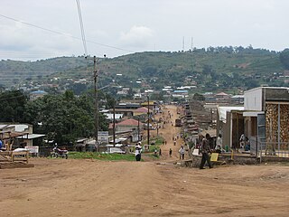
Kyenjojo is a town in the Western Region of Uganda. It is the main municipal, administrative, and commercial center of Kyenjojo District and the site of the district headquarters.

Kiruhura District is a district in the Western Region of Uganda. The town of Rushere is the site of the district headquarters.
Kyegegwa is a town in the Western Region of Uganda. It is the main municipal, administrative, and commercial center of Kyegegwa District.
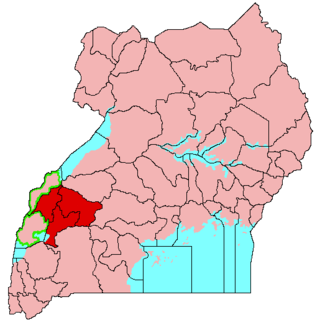
Tooro sub-region is a region in Uganda that is coterminous with Tooro Kingdom in Western Uganda.

The Tooro people, also known as Batooro or Toro people are a Bantu ethnic group, native to the Tooro Kingdom, a subnational constitutional monarchy within Uganda.
The Kyenjojo–Kabwoya Road, in the Western Region of Uganda, connects the town of Kyenjojo in the Kyenjojo District with Kabwoya in the Hoima District. The road is part of the 238 kilometres (148 mi) Kyenjojo–Hoima–Masindi–Kigumba road corridor.
The Mubende–Kyegegwa–Kyenjojo–Fort Portal Road, also Mubende–Fort Portal Road is a road in the Central and Western Regions of Uganda, connecting the towns of Mubende, in Mubende District, Kyegegwa in Kyegegwa District, Kyenjojo in Kyenjojo District and Fort Portal in Kabarole District.
Kyenjojo General Hospital, also Kyenjojo District Hospital, or Kyenjojo Government Hospital, is a hospital in the Western Region of Uganda.
Lawrence Akugizibwe is a Ugandan horticulturist, agropreneur, author, conservationist and politician. He is the elected Member of Parliament for Mwenge County North and a representative for NRM, the ruling political party in Uganda. He is a member of the Committee on HIV/AIDS & Related Diseases and the Vice Chairperson of the Committee on Agriculture in the 10th Parliament of Uganda.
Kitagwenda District is a district in Western Uganda. The district is named after Kitagwenda County, which is coterminous with the district.
Kazo is a district in Uganda's Western Region. It is located approximately 200 square kilometres (77 sq mi) west of Uganda's capital Kampala. It covers an area of 1,556 square kilometres (601 sq mi) and recorded a population of 177,054 in the 2014 Ugandan census. The capital of the district is the town of Kazo.
Matiri Central Forest Reserve is a protected tropical forest reserve that is located in Kyenjojo district of western Uganda. The central forest covers an area of 64 square kilometres (25 sq mi) and is among the few surviving natural forest reserves in the Tooro region.