Soroti is a town in Eastern Region of Uganda. It is the main municipal, commercial, and administrative centre of Soroti District, one of the nine administrative districts in the Teso sub-region.

Moroto is a town in Moroto District in the Northern Region of Uganda. It is the location of the district headquarters.

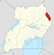
Mount Moroto, also Moroto Mountain, is a mountain in Uganda.

Busia is a town in Kenya. It is the capital and largest town of Busia County.

Katakwi is a town in the Eastern Region of Uganda. It is the main municipal, administrative, and commercial center of Katakwi District and the site of the district headquarters. It borders Moroto District.
Nakapiripirit is a town in the Nakapiripirit District of the Northern Region of Uganda. It is the seat of the district headquarters. The town is an administrative unit of the district, at the level of a sub-county; one of the eight sub-counties in the district.
The Kampala–Jinja Highway is a road in Uganda, connecting the cities of Kampala and Jinja. Sometimes referred to as Kampala–Jinja Road, it is a busy road, with several towns, trading centers and other points of interest along the way. As of October 2016, a new, wider, four-lane dual carriageway expressway, the Kampala–Jinja Expressway, is proposed to be constructed south of the present highway to relieve traffic and complement existing transport infrastructure between Kampala and Jinja.
Moroto Regional Referral Hospital, commonly known as Moroto Hospital is a hospital in the town of Moroto, in Northeastern Uganda. It is the referral hospital for the districts of Abim, Kaabong, Kotido, Moroto and Nakapiripirit and Napak.
Amudat is a town in Northern Uganda. It is the main municipal, administrative and commercial center of Amudat District and the district headquarters are located there. The district is named after the town.
Napak is a town in Northern Uganda. It is the commercial, administrative and municipal headquarters of Napak District. The district is named after the town.
Bujerere, is a settlement in the Western Region of Uganda.
Moroto–Nakapiripirit Road is a road in the Northern Region of Uganda. The road connects the towns of Moroto, the largest town in the Karamoja sub-region, and Nakapiripirit in the same sub-region.
Bumbobi–Bubulo–Lwakhakha Road is a road in the Eastern Region of Uganda, connecting the city of Mbale to the town of Lwakhakha at the International border with Kenya.
The Musita–Mayuge–Lumino–Majanji–Busia Road is a road in the Eastern Region of Uganda, connecting the town of Musita in Mayuge District to Busia in Busia District at the international border with Kenya.
The Kapchorwa–Suam Road, is a rural road in the Eastern Region of Uganda. The road links Kapchorwa, the district capital of Kapchorwa District to Suam, at the international border with Kenya.
Suam, Uganda is a border crossing between Uganda and Kenya. The settlement sits directly across the Suam River from Suam, Kenya.
Soroti–Katakwi–Moroto–Lokitanyala Road is a road in the Eastern and Northern regions of Uganda. The road connects the urban centers of Soroti, the largest city in Teso sub-region, to Katakwi, the district headquarters of Katakwi District and to Moroto, the largest city in the Karamoja sub-region. It ends at Lokitanyala, at the international border with Kenya.
Lokitanyala, Kenya is a settlement in the West Pokot County of Kenya. It sits across the international border from Lokitanyala, Uganda.
Kaabong General Hospital, also Kaabong District Hospital, is a public hospital in the Northeastern Region of Uganda.
Lorengecora is a settlement in the Northern Region of Uganda. It is the headquarters of Lorengecora Parish, in Iriri sub-county, in Bokora County, in Napak District, in the Karamoja sub-region.