
Arunachal Pradesh is a state in northeast India. It was formed from the North-East Frontier Agency (NEFA) region, and India declared it as a state on 20 February 1987. Itanagar is its capital and largest town. It borders the Indian states of Assam and Nagaland to the south. It shares international borders with Bhutan in the west, Myanmar in the east, and a disputed 1,129 km border with China's Tibet Autonomous Region in the north at the McMahon Line. It is disputed by China and claimed as part of Tibet. China occupied some regions of Arunachal Pradesh in 1962 but later withdrew its forces.

The Mishmi people are an ethnic group of Tibet and Arunachal Pradesh, India. The area is known as the Mishmi Hills. Only one group, called the Deng, occupy Zayu County in southern Tibet. The Mishmis began to identity with the legendary Vaishnava characters created during this period which led to the formation of an alternate identity.

The Adi people are one of the most populous groups of indigenous peoples in the Indian state of Arunachal Pradesh. A few thousand are also found in the Tibet Autonomous Region, where they are called the Lhoba together with some of the Nyishi people, Na people, Mishmi people and Tagin people.
The Indian state of Arunachal Pradesh has a total population of roughly 1.4 million on an area of 84,000 km2, amounting to a population density of about 17 pop./km2. The "indigenous groups" account for about two thirds of population, while immigrants, mostly of Bengali/Hindi belt origin, account for the remaining third.

Dibang Valley (Pron:/dɪˈbæŋ/) is a district of Arunachal Pradesh named after the Dibang River or the Talon as the Mishmis call it. It is the least populated district in India and has an area of 9,129 square kilometres (3,525 sq mi).

Lohit is an administrative district in the state of Arunachal Pradesh in India. The district headquarters is located at Tezu. As of 2011 it is the third most populous district of Arunachal Pradesh, after Papum Pare and Changlang.
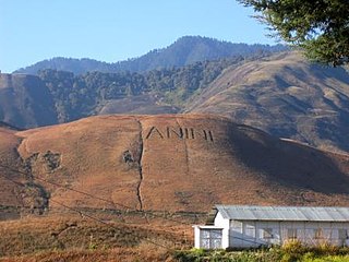
Anini is the headquarters of the Dibang Valley district in the state of Arunachal Pradesh in Northeast India. Anini was also the district headquarters of the undivided Dibang Valley district. Most of this location's population consists of the Idu Mishmi tribal people. Due to its remote location, Anini remains a small and underdeveloped town. However, it still has basic road and air links to the rest of India. The town is fully dependent on the nearest major settlement, Roing, which is in the Lower Dibang Valley District, for most commercial needs.

Pasighat is the headquarters of East Siang district in the Indian state of Arunachal Pradesh. Situated at the eastern foothills of the Himalayas at 155 meters (509 ft) above mean sea level, Pasighat is Arunachal's oldest town. The Government of India included Pasighat in the Smart Cities Mission development scheme in June 2017.
Tani, is a branch of Tibeto-Burman languages spoken mostly in Arunachal Pradesh, Assam, and neighboring regions.

The Kuki people are an ethnic group in the Northeastern Indian states of Manipur, Nagaland, Assam, Meghalaya, Tripura and Mizoram, as well as the neighbouring countries of Bangladesh and Myanmar. The Kuki constitute one of several hill tribes within India, Bangladesh, and Myanmar. In Northeast India, they are present in all states except Arunachal Pradesh.
Sadiya is a town in Tinsukia district, Assam. It was the capital of the Chutia Kingdom and after the downfall of the kingdom it became the seat of the Sadiya-khowa-Gohain of the Ahom kingdom. Extensive remains of buildings and fortifications built during the rule of the Chutias near Sadiya still point to the importance of the region in the past. Historically Sadiya referred to the Chutiya kingdom which included at times the districts of Lakhimpur, Dhemaji and Tinsukia. It is claimed to be the center of development of the eastern Assamese dialects, the inscription here are written in a Tai script. Its stands on a grassy plain, almost surrounded by forested Himalayan mountains, on the right bank of Lohit River which is locally considered the main stream of the Brahmaputra River. The deepest point of the Brahmaputra River is located near this village. It is famous for a flower named satphul, which is much like Jasmine.
Padam is a sub-tribe of the Adi tribe of Abotani clan which speaks one of the Sino-Tibetan languages. Padam makes up 20–25% of the Adis. They were a nomadic warrior race and used to had a reputation as fierce warrior by pre colonial period, they are believed to have migrated to present Arunachal Pradesh from Tibet. They were also known by the name Bor Abors in the past by their Assam counterparts and the British government.

Roing is the district headquarter of Lower Dibang Valley district in the Indian state of Arunachal Pradesh. It is the last major township at the north-eastern frontier of India.

The North-East Frontier Agency (NEFA), originally known as the North-East Frontier Tracts (NEFT), was one of the political divisions in British India, and later the Republic of India until 20 January 1972, when it became the Union Territory of Arunachal Pradesh and some parts of Assam. Its administrative headquarters was Shillong. It received the status of State on 20 February 1987.

The Lower Dibang Valley district (Pron:/dɪˈbæŋ/) is an administrative district in the state of Arunachal Pradesh in northeastern India. It is the tenth least populous district in the country.

The Idu Mishmi language is a small language spoken by the Mishmi people in Dibang Valley district, Lower Dibang Valley district, Lohit district, East Siang district, Upper Siang district of the Indian state of Arunachal Pradesh and in Zayü County of the Tibet Autonomous Region, China. There were 8569 speakers in India in 1981 and 7000 speakers in China in 1994. It is considered an endangered language.
The Milang tribe are a sub-group of the Adi people found in Arunachal Pradesh and nearby Rigbi, Jonai, in the Indian state of Assam.
The Mising people are a Sino-Tibetan indigenous ethnic group inhabiting mostly in the Northeast Indian states of Assam and Arunachal Pradesh. They are part of the greater Tani group of people of India and Tibet Autonomous Region.

Dibang River, also known as Sikang by the Adi and Talo in Idu, is an upstream tributary river of the Brahmaputra in the Indian state of Arunachal Pradesh. It originates and flows through the Mishmi Hills in the (Upper) Dibang Valley and Lower Dibang Valley districts.
The hill tribes of Northeast India are hill people, mostly classified as Scheduled Tribes (STs), who live in the Northeast India region. This region has the largest proportion of scheduled tribes in the country.