Acala | |
|---|---|
locality | |
 Acala Location in Mexico | |
| Coordinates: 16°33′12″N92°48′25″W / 16.55333°N 92.80694°W Coordinates: 16°33′12″N92°48′25″W / 16.55333°N 92.80694°W | |
| Country | |
| State | Chiapas |
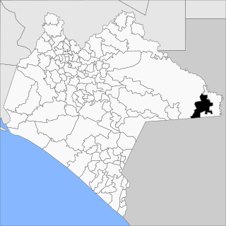
| Municipality | Acala Municipality |
| Elevation | 497 m (1,631 ft) |
| Population (2010) | |
| • Total | 13,889 |
| Climate | Aw |
| INEGI code | 070020001 |
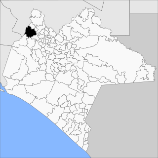
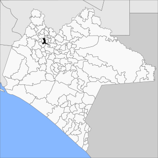
Acala is the municipal seat of Acala Municipality, in Chiapas, southern Mexico.

Acala is one of the 122 municipalities of Chiapas, in southern Mexico. The municipal seat is Acala.

Chiapas, officially the Free and Sovereign State of Chiapas, is one of the 31 states that along with the federal district of Mexico City make up the 32 federal entities of Mexico. It is divided into 124 municipalities as of September 2017 and its capital city is Tuxtla Gutiérrez. Other important population centers in Chiapas include Ocosingo, Tapachula, San Cristóbal de las Casas, Comitán and Arriaga. It is the southernmost state in Mexico. It is located in Southeastern Mexico, and it borders the states of Oaxaca to the west, Veracruz to the northwest and Tabasco to the north, and by the Petén, Quiché, Huehuetenango and San Marcos departments of Guatemala to the east and southeast. Chiapas has a coastline along the Pacific Ocean to the south.

Mexico, officially the United Mexican States, is a country in the southern portion of North America. It is bordered to the north by the United States; to the south and west by the Pacific Ocean; to the southeast by Guatemala, Belize, and the Caribbean Sea; and to the east by the Gulf of Mexico. Covering almost 2,000,000 square kilometers (770,000 sq mi), the nation is the fourth largest country in the Americas by total area and the 13th largest independent state in the world. With an estimated population of over 129 million people, Mexico is the tenth most populous country and the most populous Spanish-speaking country in the world, while being the second most populous nation in Latin America after Brazil. Mexico is a federation comprising 31 states plus Mexico City (CDMX), which is the capital city and its most populous city. Other metropolises in the country include Guadalajara, Monterrey, Puebla, Toluca, Tijuana, and León.
As of 2010, the city of Acala had a population of 13,889, [1] up from 12,686 as of 2005. [2]