
Elis or Eleia is an ancient district in Greece that corresponds to the modern regional unit of Elis.

Olympia, officially Archaia Olympia, is a small town in Elis on the Peloponnese peninsula in Greece, famous for the nearby archaeological site of the same name. This site was a major Panhellenic religious sanctuary of ancient Greece, where the ancient Olympic Games were held every four years throughout Classical antiquity, from the 8th century BC to the 4th century AD. They were restored on a global basis in 1894 in honor of the ideal of peaceful international contention for excellence.

Elis or Ilia is a historic region in the western part of the Peloponnese peninsula of Greece. It is administered as a regional unit of the modern region of Western Greece. Its capital is Pyrgos. Until 2011 it was Elis Prefecture, covering the same territory.

Vouprasia is a former municipality in Elis, West Greece, Greece. Since the 2011 local government reform it is part of the municipality Andravida-Kyllini, of which it is a municipal unit. Its seat of administration was Varda, a small town with a population of about 2,300. The municipal unit has about 8,400 inhabitants. The area of the municipal unit is 170.859 km².
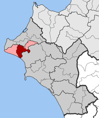
Amaliada is a town and a former municipality in northwestern Elis, West Greece, Greece. Since the 2011 local government reform it is part of the municipality Ilida, of which it is the seat and a municipal unit. The municipal unit has an area of 251.945 km2. In 2011, the municipal unit had 28,520 inhabitants, of whom 16,763 lived in the town of Amaliada. It is near the archaeological site of Elis, the city-state whose territory was the site of the ancient Olympic Games. It is situated in the plains of Elis, 6 km from the Ionian Sea. It is 10 km southeast of Gastouni, 16 km northwest of Pyrgos and 60 km southwest of Patras.
Gastouni is a town and a former municipality in Elis, West Greece, Greece. Since the 2011 local government reform it is part of the municipality Pineios, of which it is the seat and a municipal unit. The municipal unit has an area of 59.325 km2. Gastouni is situated in a flat rural area, 5 km from the Ionian Sea. The river Pineios flows into the sea near Gastouni. The town is 6 km (4 mi) south of Andravida, 4 km (2 mi) east of Vartholomio, 11 km (7 mi) northwest of Amaliada and 26 km (16 mi) northwest of Pyrgos. The population of the town proper was 7,485 in 2011. The Greek National Road 9/E55 and the railway from Patras to Pyrgos pass east of Gastouni. There is a 12th-century Byzantine church in the southwestern quarter Katholiki.

Pyrgos is a city in the northwestern Peloponnese, Greece, capital of the regional unit of Elis and the seat of the Municipality of Pyrgos. The city is located in the middle of a plain, 4 kilometres from the Ionian Sea. The river Alfeios flows into sea about 7 km (4 mi) south of Pyrgos. The population of the town Pyrgos is 25,180, and of the municipality 47,995 (2011). Pyrgos is 16 km (10 mi) west of Olympia, 16 km (10 mi) southeast of Amaliada, 70 km (43 mi) southwest of Patras and 85 km (53 mi) west of Tripoli.
Avgeio is a village in the northern part of the municipal unit of Amaliada, Elis, Greece. It is situated in a plain near the ancient city of Elis, 1 km southwest of Kalyvia, 2 km northeast of Sosti and 9 km north of Amaliada.
Agios Georgios is a community in the municipality of Pyrgos, Elis, Greece. It is situated at the foot of low hills, 3 km north of the centre of Pyrgos. It is 2 km northeast of Lasteika and 2 km southeast of Prasino, in the municipal unit Iardanos. Settlement in the village started between 1900 and 1920. It has a soccer (football) club named Nikiforos.

Lasiona is a former municipality in Elis, West Greece, Greece. Since the 2011 local government reform it is part of the municipality Archaia Olympia, of which it is a municipal unit. The municipal unit has an area of 119.528 km2. Its seat of administration was the village Antroni. Lasiona is situated in a mountainous area on the border with Achaea, 20 km north of Olympia, 27 km northeast of Pyrgos and 50 km south of Patras. The Greek National Road 33 passes through the municipal unit.
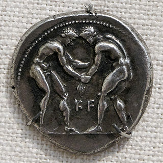
Greek wrestling, also known as Ancient Greek wrestling and Pále (πάλη), was the most popular organized sport in Ancient Greece. A point was scored when one player touched the ground with his back, hip or shoulder, or conceding defeat due to a submission-hold or was forced out of the wrestling-area. Three points had to be scored to win the match.
Varda is a town and a community in the municipal unit of Vouprasia, Elis, Greece. It was the seat of the former municipality Vouprasia. The community Varda consists of the town Varda and the villages Kougaiika, Komi, Sympanio and Psari. Varda is situated in the plains near the Ionian Sea, and east of the Kotychi lagoon. It is 2 km southeast of Manolada, 3 km southwest of Nea Manolada, 14 km northeast of Lechaina and 40 km southwest of Patras. The railway from Patras to Pyrgos passes west of the town, and the Greek National Road 9 passes east of the town.

The Peloponnese Region is a region in southern Greece. It borders Western Greece to the north and Attica to the north-east. The region has an area of about 15,490 square kilometres. It covers most of the Peloponnese peninsula, except for the northwestern subregions of Achaea and Elis which belong to Western Greece and a small portion of the Argolid peninsula that is part of Attica.
Kryoneri is a little village near Olympia, Elis, Greece. It is situated on the southwestern edge of the Foloi oak forest. It is 2 km south of Neraida, 4 km west of Doukas, 3 km east of Chelidoni and 9 km northeast of Olympia. Its population in 2011 was 139.
Myrtia or Myrtea, is a village in the municipality of Pyrgos, Elis, Greece. In 2011, it had a population of 898. It is located on a hillside near the Ionian Sea. It is 3 km southeast of Douneika, 3 km southwest of Alpochori, 3 km north of Skourochori and 9 km northwest of Pyrgos town centre. The Greek National Road 9/E55 passes northeast of the village.
Leventochori is a village in the municipality of Pyrgos, Elis, Greece. In 2011, it had a population of 204. It is located near the Ionian Sea, at the foot of a low hill. It is 1 km south of Skafidia, 3 km west of Skourochori, 4 km northeast of Katakolo and 10 km west of Pyrgos town centre.
Korakochori is a village and a community in the municipality of Pyrgos, Elis, Greece. In 2011, the village had a population of 213 and the community 281, which includes the small villages Agios Andreas, Kallithea and Bouka. It is located by the Ionian Sea, 2 km southwest of Leventochori, 3 km north of Katakolo and 11 km west of Pyrgos town centre.
Prasino is a village and a community in the municipal unit of Iardanos, Elis, Greece. It is 2 km northwest of Agios Georgios, 3 km southeast of Vounargo and 5 km northwest of Pyrgos town centre. The community consists of the villages Prasino, Glykorizo and Keramidia. Its elevation is 70 m.
Kyllini is a port town and a community in the municipal unit of Kastro-Kyllini, Elis, Greece. It is situated on the Ionian Sea coast, 11 km west of Andravida, 28 km northeast of Zakynthos and 39 km northwest of Pyrgos. From the port of Kyllini there are several ferry connections to the Ionian islands Zakynthos and Cephalonia. It was the terminus of the now dismantled Kavasila–Kyllini railway.
In ancient Greek religion and Greek mythology Sosipolis was a native god at Elis. His mother was the goddess Eileithyia. There was a sanctuary of him inside the sanctuary of Eileithyia at Olympia, Greece. There was also a shrine dedicated to him on the left of the sanctuary of Tyche in Elis.
