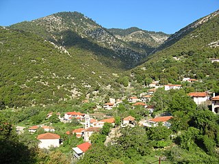
Lampeia is a mountain village, a community and a former municipality in Elis, West Greece, Greece. Since the 2011 local government reform it is part of the municipality Archaia Olympia, of which it is a municipal unit. The municipal unit has an area of 72.447 km2. In 2011 the population of the village was 468, and of the community, which includes the village Amygdali, 529.
Agia Mavra is a village in the municipal unit of Tragano, Elis, Greece. It is situated in a flat, rural area, on the left bank of the river Pineios. It is 3km South of Tragano, 4km East of Kavasila, 2km Northwest of Roupaki, 2km Northeast of Koroivos, and 6km Northeast of Gastouni.

Filiatra, is a town and a former municipality in Messenia, Peloponnese, Greece. Since the 2011 local government reform it is part of the municipality Trifylia, of which it is a municipal unit. The municipal unit has an area of 114.877 km2. Filiatra is situated near the Ionian Sea coast in western Messenia. It is located 11 km northwest of Gargalianoi, 13 km southwest of Kyparissia, 29 km northwest of Pylos and 49 km west of Kalamata. The Greek National Road 9 passes through the town. Filiatra was founded around the 12th and the 13th centuries. It was built near the site of the ancient city Erana. Filiatra has several schools, churches and shops. A scaled reproduction of the Eiffel Tower stands at the entrance to the village. The local soccer club is Erani Filiatra.
Douneika is a village and a community in the southern part of the municipal unit of Amaliada in Elis, Greece. It is situated near the Ionian Sea coast, 3 km south of Kardamas, 4 km northwest of Myrtia, 4 km west of Alpochori and 6 km south of Amaliada. The Greek National Road 9/E55 passes northeast of the village. The community consists of the villages Douneika, Agia Marina, Danika and Kato Kertezeika.

Oleni is a village and a former municipality in Elis, West Greece, Greece.
Agia Triada is a village in the northern part of the municipal unit of Lasiona, Olympia, Elis, Greece. It is situated near the river Pineios, which forms the border with Achaea here. It is located 7 km northwest of Antroni, 7 km east of Simopoulo, 9 km south of Stavrodromi and 24 km north of Olympia. The Greek National Road 33 runs through the village.

Lasiona is a former municipality in Elis, West Greece, Greece. Since the 2011 local government reform it is part of the municipality Archaia Olympia, of which it is a municipal unit. The municipal unit has an area of 119.528 km2. Its seat of administration was the village Antroni. Lasiona is situated in a mountainous area on the border with Achaea, 20 km north of Olympia, 27 km northeast of Pyrgos and 50 km south of Patras. The Greek National Road 33 passes through the municipal unit.

Tragano is a town and a former municipality in Elis, West Greece, Greece. Since the 2011 local government reform it is part of the municipality Pineios, of which it is a municipal unit. The municipal unit has an area of 41.475 km2. Tragano is situated in a flat, rural area, north of the river Pineios. It is 2 km east of Stafidokampos, 4 km east of Andravida, 3 km north of Agia Mavra, 5 km northwest of Avgeio and 8 km northeast of Gastouni. It is 2 km southeast of the Andravida Air Base.

Velventos is a town and municipality in Kozani regional unit, West Macedonia, Greece. The 2011 census recorded 3,360 people in the village of Velventos, 3,399 in the municipal community and 3,448 in the municipal unit. The municipal unit has an area of 126.516 km2, the community 54.573 km2.

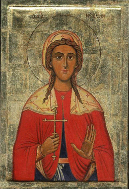
Saint Kyriaki, also known as Saint Kyriaki the Great Martyr, is a Christian saint, who was martyred under the emperor Diocletian.
Lefkochori is a village in the municipal unit of Gastouni, Elis. Its population was 546 at the 2011 census. It is situated in a flat rural area, on the left bank of the river Pineios, at about 10 m elevation. It is 1 km southeast of Kavasila, 2 km northwest of Koroivos, 3 km west of Agia Mavra and 3 km northeast of Gastouni. The Greek National Road 9 and the railway from Patras to Pyrgos pass west of the village.
Agia Kyriaki may refer to several places in Greece named after Saint Kyriaki:
Antroni is a mountain village and a community in the municipal unit of Lasiona, Elis, Olympia, Greece. The community consists of the villages Antroni, Panopoulo, Zachareika and Chania Spartoulia. Antroni is situated near the Foloi oak forest, on a small plateau between deep and narrow river valleys. It is 1 km north of Foloi, 10 km southwest of Lampeia and 19 km northeast of Olympia. The Greek National Road 33 runs through Panopoulo and Chania Spartoulia.
Kryoneri is a little village near Olympia, Elis, Greece. It is situated on the southwestern edge of the Foloi oak forest. It is 2 km south of Neraida, 4 km west of Doukas, 3 km east of Chelidoni and 9 km northeast of Olympia. Its population in 2011 was 139.
Kryovrysi is a mountain village and a community in the municipal unit of Lasiona, Olympia, Elis, Greece. The community consists of the villages Kryovrysi and Kalyvia. It is situated in the southwestern foothills of Mount Erymanthos, at 960 m elevation. It is 4 km west of Agrampela, 5 km southeast of Kalentzi, 7 km north of Lampeia and 15 km northeast of Antroni. The source of the river Pineios is near Kryovrysi. Downstream from Kryovrysi, near the river bed of the Pineios, is the cave Drakotrypa.
Goumero is a village in the municipal unit of Oleni, Elis, Greece. In 2011 its population was 642. It is situated on a hillside in the western foothills of the Foloi plateau, at 500 m elevation. It is 2 km southwest of Agia Anna, 5 km northwest of Neraida, 8 km northeast of Karatoula and 13 km north of Olympia.
Agia Anna is a mountain village in the municipal unit of Oleni, Elis, Greece. In 2011 its population was 168. Agia Anna is built on the slopes of the hill Axofolia, a western spur of the Foloi plateau. In the village square, the elevation is 450 m, and the top of the hill is around 670 m. Agia Anna is 2 km northeast of Goumero, 4 km west of Klindia, 10 km southeast of Simopoulo and 10 km northeast of Karatoula. The area is forested, but suffered damage from the 2007 Greek forest fires.

Oreini is a mountain village and a community in the municipal unit of Lampeia, Elis, Olympia, Greece. Oreini is built on the slopes of Mount Lampeia, part of the Erymanthos range. The community Oreini consists of the villages Oreini and Paliofytia. The population in 2011 was 194 for the village and 206 for the community. Oreini is located 4 km east of Lampeia, 4 km west of Psofida, 6 km south of Agrampela and 32 km northeast of Olympia. The former name of the village, Bostenitsa, suggests a Slavic origin. The revolutionary leader Theodoros Papasimakopoulos, who fought in the Greek War of Independence, was from Bostenitsa.
Irakleia is a village in the municipality of Ancient Olympia, Elis, Greece. Its population in 2011 was 272. Irakleia is located 3 km northwest of Pelopio, 6 km southeast of Karatoula, 7 km northwest of Olympia and 15 km northeast of Pyrgos.


