Adamello Brenta Natural Park

Last updated
Parco naturale Adamello Brenta
IUCN category IV (habitat/species management area) [1]
Adamello Lobbie 1.jpg
Relief map of Italien Trentino-Sudtirol.png
Red pog.svg
Location in Trentino
Italy relief location map.jpg
Red pog.svg
Location in Italy
Location Trentino, Italy
Coordinates 46°13′N10°52′E / 46.22°N 10.86°E / 46.22; 10.86
Area62,051 hectares
Established1967
www.pnab.it

The Adamello Brenta Natural Park (Italian : Parco naturale Adamello Brenta) is a nature reserve in Trentino, Italy. Established in 1967, it encompasses most of the Adamello-Presanella Alps as well as the Brenta Dolomites; it is the largest natural park in Trentino and along with the adjacent Stelvio National Park, Swiss National Park and Adamello Regional Park, it forms the largest protected area in the Alps, nearly 400,000 hectares. [2] [3] [4] It joined the Global Geoparks Network in 2008, becoming a UNESCO Global Geopark when the designation was ratified in 2015. [5]

Contents

Flora and fauna

The park is home to 1,300 species of plants and flowers as well as numerous animals, including the brown bear; in fact, by the 1990s the last surviving specimens of brown bear in the Italian Alps lived in the Brenta Dolomites, and the population was brought back from near-extinction (two or three specimens) to the current population of over ninety specimens thanks to a reintroduction project funded by the European Union, making the brown bear the symbol of the park. The park's fauna also includes 8,000 chamoises, 3,500 roe deer and 1,300 red deer, as well as alpine ibexes, marmots, and 113 species of birds, including twenty-eight golden eagles. 41 glaciers and 48 lakes are located within its territory, as well as twelve mountain huts, seven visitor centers and over 1,000 kilometers of hiking paths; the highest point of the park is Cima Adamello, 3,558 meters above sea level, whereas the lowest point is 447 meters above sea level. [6] [7] [8]

Related Research Articles

<span class="mw-page-title-main">Dolomites</span> Mountain range in the Italian Alps

The Dolomites also known as the Dolomite Mountains, Dolomite Alps or Dolomitic Alps, are a mountain range in northeastern Italy. They form part of the Southern Limestone Alps and extend from the River Adige in the west to the Piave Valley in the east. The northern and southern borders are defined by the Puster Valley and the Sugana Valley. The Dolomites are in the regions of Veneto, Trentino-Alto Adige/Südtirol and Friuli Venezia Giulia, covering an area shared between the provinces of Belluno, Vicenza, Verona, Trentino, South Tyrol, Udine and Pordenone.

<span class="mw-page-title-main">Province of Brescia</span> Province of Italy

The province of Brescia is a province in the Lombardy administrative region of northern Italy. It has a population of some 1,265,964 and its capital is the city of Brescia.

<span class="mw-page-title-main">Brenta group</span> Alpine mountain range in northeastern Italy

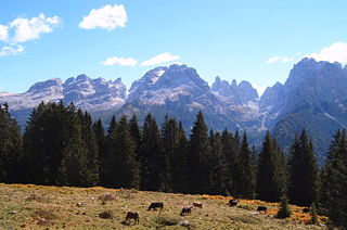
The Brenta Group or Brenta Dolomites is a mountain range, and a subrange of the Rhaetian Alps in the Southern Limestone Alps mountain group. They are located in the Province of Trentino, in northeastern Italy. It is the only dolomitic group west of the Adige River. Therefore, geographically, they have not always been considered a part of the Dolomites mountain ranges. Geologically, however, they definitely are - and therefore sometimes called the "Western Dolomites". As part of the Dolomites, the Brenta Group has been officially recognized as UNESCO World Heritage Site under the World Heritage Convention.

<span class="mw-page-title-main">Romedius</span>

Saint Romedius. Though the son of a nobleman, as a young man he withdrew to a rock cave in order to meditate. After the death of his parents, he gave away all of his possessions and established himself in the Val di Non in Trentino.

<span class="mw-page-title-main">Val Camonica</span>

Val Camonica is one of the largest valleys of the central Alps, in eastern Lombardy, Italy. It extends about 90 kilometres (56 mi) from the Tonale Pass to Corna Trentapassi, in the commune of Pisogne near Lake Iseo. It has an area of about 1,335 km2 (515 sq mi) and 118,323 inhabitants.

<span class="mw-page-title-main">Sarca</span> River in Italy

The Sarca is a river springing from the Adamello-Presanella mountains in the Italian Alps and flowing into Lake Garda at Torbole. As an emissary of the lake it becomes known as the Mincio river, forming a single river system 203 kilometres (126 mi) long (Sarca-Mincio).

<span class="mw-page-title-main">Val di Sole</span> Valley in Italy

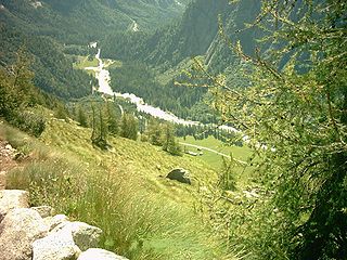
The Sole Valley is a valley in Trentino, northern Italy.

<span class="mw-page-title-main">Molveno</span> Comune in Trentino-Alto Adige/Südtirol, Italy

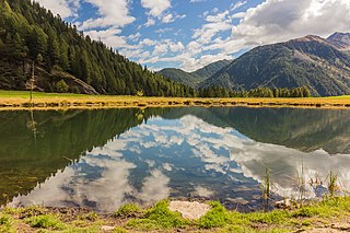
Molveno is a comune (municipality) in Trentino in the northern Italian region of Trentino-Alto Adige/Südtirol, located about 40 kilometres (25 mi) northwest of Trento. It is famous for its positioning on Lake Molveno as a holiday destination, its nearby ski resorts (Andalo-Paganella) and its connection to the National Park Adamello Brenta.

<span class="mw-page-title-main">Chiese (river)</span> River in Italy

The Chiese, also known in the Province of Brescia as the Clisi, is a 160-kilometre (99 mi) Italian river that is the principal immisary and sole emissary of the sub-alpine lake Lago d’Idro, and is a left tributary of the Oglio.

<span class="mw-page-title-main">Stelvio National Park</span>

Stelvio National Park is a national park in northeast Italy, established in 1935.

The European Geoparks Network (EGN) functions as the regional organization of the Global Geoparks Network (GGN) and the UNESCO International Geosciences and Geoparks Programme (UNESCO-IGGP). Its main objective is to ensure cooperation between geoparks for the protection of geological heritage and the promotion of sustainable development of their territories in Europe. In 2020 January, the EGN had 75 institutional members from 26 European countries and there are several aspiring geopark projects, applying for a UNESCO label and therefore the permanent EGN membership.

<span class="mw-page-title-main">Madonie Regional Natural Park</span>

The Madonie Regional Natural Park is an Italian regional park located in Sicily, between Palermo and Cefalù and covers 39,972 acres.

<span class="mw-page-title-main">Cima Brenta</span> Mountain in the Rhaetian Alps in Italy

Cima Brenta is the highest mountain in the Brenta group, a subgroup of the Rhaetian Alps in the Italian Region of Trentino-Alto Adige, with a reported height of 3,150 metres (10,330 ft). The mountain rises imposingly up between the rock towers and pinnacles of the central Brenta Group. A sharp ridge connects the mountain on its southern side to the Spallone die Massodi. The northern ridge steeply descends towards Bocca del Tuckett. Towards north west a slender couloir descends all the way from the top towards the Vedretta di Brenta Inferiore, the mountain's 'lower' glacier. Large shouldering formations extend towards the west, culminating in the Cima Mandrone and the Punti di Campiglio, and northwest, culminating in the Cima Massari. Above these formations a glacier, the Vedretta di Brenta Superiore, the 'upper' glacier descends the mountain, being cut off by a vertical precipice over the Vedretta di Brenta Inferiore. On the eastern side the mountain rises up with an imposing 700-meter high vertical rock face with on its left side a distinct orange-like color. Above this lies a horizontal ledge, the Cengia Garbari, on which the Via delle Bocchette Alte proceeds. The actual mountain has two summits that are some 250 meters apart, of which the eastern top reaches the highest altitude. The glaciers, vedrette, have been shrinking steadily over the last decades as a result of climate change. The historical name Cima Brenta was not always as evident as it is today. The toponymy of these parts was largely established by Nepomuceno Bolognini. The mountain, somehow, became a place where nationalistic sentiments were demonstrated. In 1889 the Austro-Hungarian authorities decided to rename the mountain to Kaiser Franz Josef-Spitze. The name never caught on -not even in German literature. When the occasion occurred to raise a large yellow-black imperial flag on the summit, fully visible from Val Rendena as well as from Molveno, local guide Giuseppe 'Bepaccia' Zeni and some companions climbed the mountain to take it down. In 1912, on the other hand, the Italian flag was hoisted by irredentists on Cima Brenta, deliberately just before the first snow fall, so that the flag remained visible until the next summer. Around 1953 electricity company SISM, predecessor of ENEL proposed to build a cable car trajectory from Molveno to the top of Cima Brenta. The plans were abandoned and in 1967 the mountain became protected as part of the Parco Naturale Adamello-Brenta.

<span class="mw-page-title-main">Dolomiti Bellunesi National Park</span> UNESCO World Heritage Site

The Dolomiti Bellunesi National Park is a national park in the province of Belluno, Veneto, in the northern Italy.

<span class="mw-page-title-main">Natural Park of Marguareis</span> Nature reserve in Italy

The Natural Park of Marguareis(in Italian Parco Naturale del Marguareis) is a regional natural park of the Ligurian Alps located in the Province of Cuneo.

<span class="mw-page-title-main">Adamello Regional Park</span> Protected area in Italy

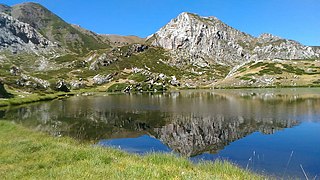
The Adamello Regional Park is a nature reserve in Lombardy, Italy. Established in 1983, it encompasses the Lombard portion of the Adamello-Presanella Alps; together with the adjacent Stelvio National Park, Swiss National Park and Adamello Brenta Natural Park, it forms the largest protected area in the Alps, nearly 400,000 hectares.

<span class="mw-page-title-main">Friulian Dolomites</span> Alpine mountain range in northeastern Italy

The Friulian Dolomites, also known as Dolomiti d'Oltre Piave are a mountain range in the Carnic and Gailtal Alps. They are located in northeastern Veneto and Friuli Venezia Giulia, in northeastern Italy. They are the easternmost dolomitic group. As part of the Dolomites, they have been officially recognized as UNESCO World Heritage Site under the World Heritage Convention, and most of their area is also covered by the Friulian Dolomites Natural Park.

<span class="mw-page-title-main">Paneveggio-Pale di San Martino Natural Park</span> Nature reserve in Trentino-Alto Adige, Italy

The Paneveggio-Pale di San Martino Natural Park is a nature reserve in Trentino, Italy. Established in 1967, it stretches over nearly 20,000 ha in the Dolomites, encompassing the Pale di San Martino massif, the Paneveggio forest, and the easternmost part of the Lagorai range, between the valleys of Fiemme, Fassa, Primiero, and Vanoi.

<span class="mw-page-title-main">Ampezzo Dolomites Natural Park</span> Nature reserve in Veneto, Italy

The Ampezzo Dolomites Natural Park is a nature reserve in Veneto, Italy. Established in 1990, it is entirely located in the territory of Cortina d’Ampezzo, in the Province of Belluno, and encompasses some of the most famous Dolomitic groups, such as the Tofane, Monte Cristallo, the Croda Rossa d'Ampezzo, Lagazuoi, Pomagagnon and Col Bechei. Together with the adjacent Naturpark Fanes-Sennes-Prags in the Province of Bolzano, it forms a protected area of 37,000 hectares in the heart of the Dolomites. The park has been designated as a Site of Community Importance, and about one quarter of its territory is afforded further protection through twenty smaller reserves.

References

  1. Protected Area Profile for 'Parco naturale provinciale dell Adamello Brenta' Archived December 3, 2023, at the Wayback Machine from the World Database on Protected Areas. Retrieved December 3, 2023.
  2. Visittrentino - Parco naturale Adamello Brenta
  3. Visitvaldisole - Parco naturale Adamello Brenta
  4. Ponte di Legno Tonale
  5. "Adamello-Brenta UNESCO Global Geopark" . Retrieved 18 January 2023.
  6. Ponte di Legno Tonale
  7. Visitvaldisole - Parco naturale Adamello Brenta
  8. Comune di Strombo

Commons-logo.svg Media related to Parco naturale provinciale dell'Adamello-Brenta at Wikimedia Commons