Adilang

Last updated
Adilang
Uganda location map.svg
Red pog.svg
Adilang
Map of Uganda showing the location of Adilang.
Coordinates: 02°44′24″N33°28′48″E / 2.74000°N 33.48000°E / 2.74000; 33.48000
Country Flag of Uganda.svg Uganda
Region Northern Region of Uganda
Sub-region Acholi sub-region
District Agago District
Elevation
1,100 m (3,600 ft)
Time zone UTC+3 (EAT)

Adilang is a town in the Northern Region of Uganda.

Contents

Location

The town is in Adilang sub-county, Agago District, Acholi sub-region. It is approximately 40 kilometres (25 mi) southeast of Agago, where the district headquarters are located. [1] This is approximately 170 kilometres (110 mi), directly east of Gulu, the largest urban center in the Northern Region. [2] The coordinates of Adilang are:2° 44' 24.00"N, 33° 28' 48.00"E (Latitude:2.7400; Longitude:33.4800). [3]

Overview

Adilang is an urban center and administered by the Adilang Town Council, an urban local government.

Points of interest

The following points of interest are located inside the town or near its edges:

See also

Related Research Articles

Atiak Municipality in Northern Region of Uganda, Uganda

Atiak is a town in the Northern Region of Uganda on the Gulu-Nimule Road, the primary trade route between Uganda and South Sudan.

Abim District District in Uganda

Abim District is a district in Northern Uganda. It's named after its 'chief town', Abim, where the district headquarters are located.

Abim, Uganda Ugandan town

Abim is a town in the Northern Region of Uganda. It is the chief municipal, administrative, and commercial center of Abim District. The district is named after the town.

Kapeeka Place in Central Region of Uganda, Uganda

Kapeeka is a town in Nakaseke District of the Central Region of Uganda.

Patongo, Uganda Place in Uganda

Patongo is a town in Agago District, Acholi sub-region in the Northern Region of Uganda. The town is administered by Patongo Town Council

Kiwoko Place in Central Region, Uganda

Kiwoko is a small town in the Central Region of Uganda. It is one of the municipalities in Nakaseke District.

Pabbo Municipality in Northern Region of Uganda, Uganda

Pabbo, sometimes spelled as Pabo, is a municipality in Amuru District of the Northern Region of Uganda.

Anaka Town Council in Northern Region, Uganda

Anaka is a town in the Northern Region of Uganda. It is the site of the Nwoya District headquarters.

Karuma Falls Place in Western Region, Uganda

Karuma Falls is a town in Uganda.

Agago District District in Uganda

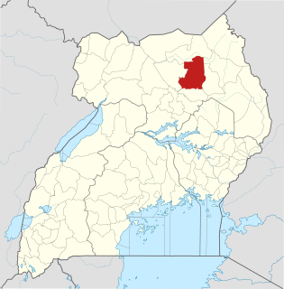
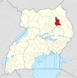
The Agago District is a Ugandan district located in North east Uganda.

Agago Place in Northern Region, Uganda

Agago is a town in the Northern Region of Uganda. It is the chief political, administrative, and commercial center of the Agago District.

Kiryandongo Place in Western Region of Uganda, Uganda

Kiryandongo is a town in the Western Region of Uganda. It is the main municipal, administrative, and commercial center of Kiryandongo District.

Kalongo Place in Northern Region of Uganda, Uganda

Kalongo is a town in the Northern Region of Uganda. It is one of the urban centers in Agago District.

Bibia Municipality in Northern Region of Uganda, Uganda

Bibia is a municipality in the Amuru District of the Northern Region of Uganda.

The Acholibur–Gulu–Olwiyo Road is a road in the Northern Region of Uganda, connecting the town of Acholibur to the city of Gulu and the town of Olwiyo.

Acholibur Place in Northern Region of Uganda, Uganda

Acholibur is a town in Pader District in the Northern Region of Uganda.

Rwekunye Place in Western Region of Uganda, Uganda

Rwekunye is a settlement in Kiryandongo District in the Western Region of Uganda.

Bobi, Uganda Place in Uganda

Bobi is a town in the Northern Region of Uganda.

Omoro District is a district in the Northern Region of Uganda.

Kibiito Place in Uganda

Kibiito is a town in the Western Region of Uganda. It is the chief administrative center of Bunyangabu District, and the district headquarters are located there.

References

  1. "Map Showing Agago And Pader With Route Marker". Globefeed.com (GFC). 11 July 2015. Retrieved 11 July 2015.
  2. "Road Distance Between Gulu And Adilang With Map". Globefeed.com (GFC). 11 July 2015. Retrieved 11 July 2015.
  3. Google (11 July 2015). "Location of Adilang At Google Maps" (Map). Google Maps . Google. Retrieved 11 July 2015.

Coordinates: 02°44′24″N33°28′48″E / 2.74000°N 33.48000°E / 2.74000; 33.48000