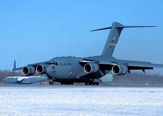
Wright-Patterson Air Force Base (WPAFB) is a United States Air Force base and census-designated place just east of Dayton, Ohio, in Greene and Montgomery counties. It includes both Wright and Patterson Fields, which were originally Wilbur Wright Field and Fairfield Aviation General Supply Depot. Patterson Field is approximately 16 kilometres (10 mi) northeast of Dayton; Wright Field is approximately 8.0 kilometres (5 mi) northeast of Dayton.

Imagery intelligence (IMINT), pronounced as either as Im-Int or I-Mint, is an intelligence gathering discipline wherein imagery is analyzed to identify information of intelligence value. Imagery used for defense intelligence purposes is generally collected via satellite imagery or aerial photography.
Measurement and signature intelligence (MASINT) is a technical branch of intelligence gathering, which serves to detect, track, identify or describe the distinctive characteristics (signatures) of fixed or dynamic target sources. This often includes radar intelligence, acoustic intelligence, nuclear intelligence, and chemical and biological intelligence. MASINT is defined as scientific and technical intelligence derived from the analysis of data obtained from sensing instruments for the purpose of identifying any distinctive features associated with the source, emitter or sender, to facilitate the latter's measurement and identification.

The Air Force Institute of Technology (AFIT) is a postgraduate institution and provider of professional and continuing education for the United States Armed Forces and is part of the United States Air Force. It is in Ohio at Wright-Patterson Air Force Base, near Dayton. AFIT is a component of the Air University and Air Education and Training Command.
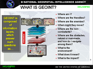
In the United States, geospatial intelligence (GEOINT) is intelligence about the human activity on Earth derived from the exploitation and analysis of imagery, signals, or signatures with geospatial information. GEOINT describes, assesses, and visually depicts physical features and geographically referenced activities on the Earth. GEOINT, as defined in US Code, consists of imagery, imagery intelligence (IMINT) and geospatial information.

The Missile and Space Intelligence Center (MSIC) is a component of the U.S. Defense Intelligence Agency. MSIC is located at Redstone Arsenal in Huntsville, Alabama.

The 18th Intelligence Squadron is an intelligence organization of the United States Air Force, located at Buckley Space Force Base, Colorado.

The Defense Technical Information Center is the repository for research and engineering information for the United States Department of Defense (DoD). DTIC's services are available to DoD personnel, federal government personnel, federal contractors and selected academic institutions. The general public can access unclassified information through its public website.
Materials MASINT is one of the six major disciplines generally accepted to make up the field of Measurement and Signature Intelligence (MASINT), with due regard that the MASINT subdisciplines may overlap, and MASINT, in turn, is complementary to more traditional intelligence collection and analysis disciplines such as SIGINT and IMINT. MASINT encompasses intelligence gathering activities that bring together disparate elements that do not fit within the definitions of Signals Intelligence (SIGINT), Imagery Intelligence (IMINT), or Human Intelligence (HUMINT).
Radar MASINT is a subdiscipline of measurement and signature intelligence (MASINT) and refers to intelligence gathering activities that bring together disparate elements that do not fit within the definitions of signals intelligence (SIGINT), imagery intelligence (IMINT), or human intelligence (HUMINT).
This article deals with activities of the U.S. Central Intelligence Agency, specifically dealing with arms control, weapons of mass destruction (WMD) and weapons proliferation. It attempts to look at the process of tasking and analyzing, rather than the problem itself, other than whether the CIA's efforts match its legal mandate or assists in treaty compliance. In some cases, the details of a country's programs are introduced because they present a problem in analysis. For example, if Country X's policymakers truly believe in certain history that may not actually be factual, an analyst trying to understand Country X's policymakers needs to be able to understand their approach to an issue.

Siva Subrahmanyam Banda is an Indian-American aerospace engineer. He was Director of the Control Science Center of Excellence and Chief Scientist for the Aerospace Systems Directorate at the United States Air Force Research Laboratory at Wright-Patterson Air Force Base. He has taught at Wright State University, the University of Dayton, and the Air Force Institute of Technology.
Geographic information systems (GIS) play a constantly evolving role in geospatial intelligence (GEOINT) and United States national security. These technologies allow a user to efficiently manage, analyze, and produce geospatial data, to combine GEOINT with other forms of intelligence collection, and to perform highly developed analysis and visual production of geospatial data. Therefore, GIS produces up-to-date and more reliable GEOINT to reduce uncertainty for a decisionmaker. Since GIS programs are Web-enabled, a user can constantly work with a decision maker to solve their GEOINT and national security related problems from anywhere in the world. There are many types of GIS software used in GEOINT and national security, such as Google Earth, ERDAS IMAGINE, GeoNetwork opensource, and Esri ArcGIS.

Wright-Patt Credit Union (WPCU) is a US credit union or financial cooperative headquartered in Beavercreek, Ohio. The credit union was originally headquartered in Fairborn, Ohio; however, it relocated in early 2014. WPCU is registered as a state-chartered credit union, is the largest member-owned credit union in Ohio, and is one of the 50 largest credit unions in the United States. As of February 2022, WPCU has over $7.1 billion in assets, and over 446,000 members. WPCU is federally insured by the National Credit Union Administration (NCUA), which insures accounts in federal and most state-chartered credit unions in the United States. Deposits with Wright-Patt Credit Union are insured to $250,000.

The National Air and Space Intelligence Center (NASIC) is the United States Air Force unit for analyzing military intelligence on foreign air and space forces, weapons, and systems. NASIC assessments of aerospace performance characteristics, capabilities, and vulnerabilities are used to shape national security and defense policies and support weapons treaty negotiations and verification. NASIC provides the Defense Intelligence Agency (DIA) with specialized intelligence regarding foreign air and space threats.
Acquisition Intelligence is the field that combines military intelligence, acquisition processes, and logistics fundamentals to ensure supportability of weapons systems. Acq Intel originated within the Air Force Materiel Command at Wright Patterson AFB circa 2004, and matured into a numbered USAF Squadron. It is offered as a college certificate program.
All-source intelligence is a term used to describe intelligence organizations, intelligence analysts, or intelligence products that are based on all available sources of intelligence collection information.

Space Delta 18 is a United States Space Force unit that serves as the National Space Intelligence Center (NSIC). It is headquartered at Wright-Patterson Air Force Base, Ohio and activated on 24 June 2022.

The United States Army Geospatial Intelligence Battalion, previously known as the 3rd Military Intelligence Center, is a military intelligence battalion specializing in the production and exploitation of geospatial intelligence (GEOINT), and the only operational military command at the National Geospatial-Intelligence Agency (NGA). Co-located within the NGA headquarters (NGA-East) on Fort Belvoir in Springfield, Virginia, the unit produces and analyzes geospatial intelligence products for ground combat forces in close collaboration with its host agency and other members of the U.S. Intelligence Community. Though colocated with NGA, the AGB differs from NGA's own Support Teams in that it receives tasking from the Army.