
The River Taff is a river in Wales. It rises as two rivers in the Brecon Beacons; the Taf Fechan and the Taf Fawr before becoming one just north of Merthyr Tydfil. Its confluence with the River Severn estuary is in Cardiff.

Afon Mellte or the River Mellte is a river in south Wales. It is formed by the confluence of the Afon Llia and the Afon Dringarth. It then flows south through the village of Ystradfellte to Pontneddfechan where it joins with the Nedd Fechan to become the River Neath. The river derives its name from 'mellt' - the Welsh word for 'lightning' - after its tendency to rise and fall rapidly in response to heavy rainfall.

River Neath is a river in south Wales running south west from the point at which its headwaters arising in the Brecon Beacons National Park converge to its mouth at Baglan Bay below Briton Ferry on the east side of Swansea Bay.

The River Cynon in South Wales is a main tributary of the Taff. Its source is the rising of Llygad Cynon at 219m above sea level at Penderyn, Rhondda Cynon Taf and flows roughly southeast, into the Taff at Abercynon in the same district. The water emerging at Llygad Cynon has been traced back to the sink of the Nant Cadlan at Ogof Fawr.
The Nedd Fechan is a river almost wholly within the county of Powys, Wales, currently administered as part of the unitary authority of Powys. It rises on the eastern slopes of Fan Gyhirych in the Fforest Fawr section of the Brecon Beacons National Park and flows south for 7 miles (12 km) to join with the Afon Mellte at Pontneddfechan, their combined waters continuing as the River Neath to the sea near Swansea. The only significant tributary of the Nedd Fechan is the Afon Pyrddin which joins it at Pwll Du ar Byrddin. Downstream of this confluence it forms the boundary between Powys to its east and Neath Port Talbot to its west.
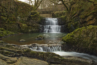
The Afon Pyrddin is a river forming a short section of the boundary between the counties of Brecknockshire and Glamorgan in Wales, Great Britain. It also forms a part of the boundary of the Brecon Beacons National Park, and the boundary of the unitary authorities of Powys and Neath Port Talbot. The river and its waterfalls are one of the key attractions of the Fforest Fawr Geopark designated in 2005.

The River Giedd is a principal tributary of the River Tawe, Wales. The river runs within the county of Powys and lies almost wholly within the Brecon Beacons National Park.

The Afon Twrch is a river which rises in the Black Mountain in south Wales. It forms the boundary between the counties of Brecknockshire and Carmarthenshire and, downstream of Ystradowen, between Brecknockshire and Glamorgan.
The Nant Gwys is a river flowing off the Black Mountain in Powys, Wales. Its tributaries Gwys Fawr and the Gwys Fach flow south from Banwen Gwyn and Bwlch y Ddeuwynt respectively and join forces to form the Nant Gwys proper which then flows for about 5 km / 3 mi to its confluence with the Afon Twrch at Cwm-twrch-Uchaf.

The Afon Tarell is a river in Powys, Wales, which rises to the west of the Brecon Beacons in Brecon Beacons National Park and flows north, then north-east, for 12 miles (20 km) into the River Usk.

Llyn Cwm Llwch is a small lake or pool in the Brecon Beacons National Park in Powys, Wales. It is between 1 and 2 acres: much smaller than the two glacial lakes in the west of the Black Mountain (range): Llyn y Fan Fawr and Llyn y Fan Fach, and one of the few natural bodies of water in the park. It is of glacial origin, occupying a rock hollow beneath the peaks of Pen y Fan and Corn Du in the central Brecon Beacons. It is drained by the Nant Cwm Llwch which empties into the Afon Tarell, which itself enters the River Usk at Brecon. Tommy Jones' obelisk, a memorial in granite to a young boy who died near this spot in 1900, overlooks the lake.

The Afon Cynrig is a river in Powys, Wales whose headwaters rise in the central Brecon Beacons and flow northwards to join the River Usk at Abercynrig just east of Brecon.
The Afon Sawdde is a river in the county of Carmarthenshire, Wales. For most of its course it flows through the Brecon Beacons National Park and Fforest Fawr Geopark.

Tair Carn Uchaf is a hill in the Brecon Beacons National Park in the county of Carmarthenshire, Wales. Its summit sits atop a plateau-like ridge at 482 metres (1,580 ft) above sea level and is marked by one of the three huge cairns which give the mountain its name.

Waun Lefrith is a top of Picws Du and is also the westernmost of the Carmarthen Fans or Bannau Sir Gaer, a group of peaks within the Black Mountain of the Brecon Beacons National Park. It lies within Carmarthenshire, Wales. The summit plateau of the mountain reaches a height of 2221 feet above sea level. Picws Du and Fan Foel are the other, higher summits of the Bannau Sir Gaer / Carmarthen Fans. The glacial lake of Llyn y Fan Fach dominates the panorama to the north of the peak. Beyond the lake to the north lies the Usk Reservoir and then the Cambrian Mountains on the horizon. Swansea Bay and the Bristol Channel are visible to the south across the undulating dip slope of the mountain. The Tywi valley lies to the west, with Llandovery and Llandeilo as important market towns nearest to the hills.
The Afon Llynfi is a short river in the county of Powys, south Wales. A tributary of the River Wye, it runs approximately south to north just to the west of the Black Mountains and partly within the Brecon Beacons National Park. The river rises as a small stream to the west of the village of Bwlch and flows north for two miles into Llangorse Lake. It leaves the lake just to the southwest of the village of Llangors and follows a course past the hamlets of Trefecca and Tredustan. The river then travels between the twin villages of Talgarth and Bronllys, forming the boundary of the national park in part. It then flows northeast past the village of Three Cocks before entering the River Wye just upstream of Glasbury Bridge.
The Afon Hydfer is a short river in Powys in the west of the Brecon Beacons National Park, south Wales. Its headwaters rise on the northeastern slopes of the Black Mountain as the streams named Trinant, Nant y Cadno, Nant yr Erydr and Crognant joining to flow down Cwm yr Afon on the western edge of Glasfynyd Forest. The river turns east at Blaenau Uchaf, then northeast through Cwm Hydfer and joins the River Usk just below Pont ar Hydfer. Other tributaries of the Hydfer include the streams of Nant Cil-y-clawdd, Nant Crinog and Nant Meity.
Waterfall Country is an English name often given to the Vale of Neath in South Wales. The tourist area around the head of valley has an unusually large number of publicly accessible waterfalls. The area is not officially defined but generally includes the group of falls on the Nedd Fechan, Pyrddin, Hepste and Mellte rivers, all of which lie between the villages of Pontneddfechan and Ystradfellte in the Brecon Beacons National Park.
The Afon Sychryd is a river in Rhondda Cynon Taf, Wales. Although it is a relatively short river, with a total length of 3 miles (5 km), it is notable for the gorge and two waterfalls through which it flows.

