
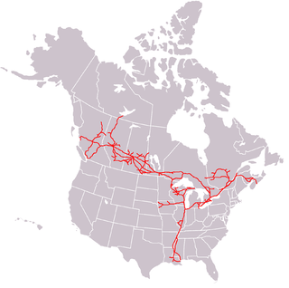
The Canadian Pacific Railway, also known simply as CPR or Canadian Pacific and formerly as CP Rail (1968–1996), was a Canadian Class I railway incorporated in 1881. The railway was owned by Canadian Pacific Railway Limited, which began operations as legal owner in a corporate restructuring in 2001.
The Canadian National Railway Company is a Canadian Class I freight railway headquartered in Montreal, Quebec, which serves Canada and the Midwestern and Southern United States.

The Kettle Valley Railway was a subsidiary of the Canadian Pacific Railway (CPR) that operated across southern British Columbia, west of Midway running to Rock Creek, then north to Myra Canyon, down to Penticton over to Princeton, Coalmont, Brookmere, Coquihalla and finally Hope where it connected to the main CPR line.

Union Station is a major railway station and intermodal transportation hub in Toronto, Ontario, Canada. It is located on Front Street West, on the south side of the block bounded by Bay Street and York Street in downtown Toronto. The municipal government of Toronto owns the station building while the provincial transit agency Metrolinx owns the train shed and trackage. Union Station has been a National Historic Site of Canada since 1975, and a Heritage Railway Station since 1989. It is operated by the Toronto Terminals Railway, a joint venture of the Canadian National Railway and Canadian Pacific Railway that directs and controls train movement along the Union Station Rail Corridor, the largest and busiest rail corridor in Canada.

Waterfront station is a major intermodal public transportation facility and the main transit terminus in Vancouver, British Columbia, Canada. It is located on West Cordova Street in Downtown Vancouver, between Granville and Seymour Street. The station is also accessible via two other street-level entrances, one on Howe Street to the west for direct access to the Expo Line and another on Granville Street to the south for direct access to the Canada Line.

The Canadian is a transcontinental passenger train operated by Via Rail with service between Union Station in Toronto, Ontario and Pacific Central Station in Vancouver, British Columbia, Canada.

The Atlantic was a passenger train operated by Via Rail, serving both Canadian and U.S. territory between Montreal, Quebec and Halifax, Nova Scotia. It was previously operated by Canadian Pacific Railway as The Atlantic Limited between Montreal and Saint John, New Brunswick. It formed part of the transcontinental service for both systems.

Windsor Station is a former railway station in Montreal, Quebec, Canada. It used to be the city's Canadian Pacific Railway (CPR) station, and served as the headquarters of CPR from 1889 to 1996. It is bordered by Avenue des Canadiens-de-Montréal to the north, Peel Street to the east, Saint Antoine Street to the south and the Bell Centre to the west.

Coquitlam Central station is an intermodal rapid transit station in Metro Vancouver served by both the Millennium Line—part of the SkyTrain system—and the region's West Coast Express commuter rail system. The station is located on the north side of the Canadian Pacific Railway (CPR) tracks in Coquitlam, just west of the Lougheed Highway rail overpass, near the Coquitlam Centre shopping mall. 601 parking spaces are available on site. All services are operated by TransLink.

The Biggar station is a heritage railway station operated by Via Rail located in Biggar, Saskatchewan, Canada.
The Canadian National Railway (C.N.) Yards Management Area located on Chappell Drive, Saskatoon, Saskatchewan consists of the VIA Saskatoon railway station and the train switching yards. These yards are a part of the Confederation Suburban Development Area (SDA). It lies (generally) north of the outskirts of the City and the Rural Municipality of Corman Park No. 344, west of Montgomery Place, south of 11th Street and east of Highway 7. Highway 7 has built an overpass over C.N. tracks where they intersect. This neighbourhood is not to be confused with the C.N. Industrial in the Nutana SDA on the east side of Saskatoon. These two sides of Saskatoon are connected with the Grand Trunk Bridge or CN railway bridge over the South Saskatchewan River.
The Kawartha Lakes Railway was a Canadian rail line. It was created in 1996 to assume the operations of the Havelock and Nephton Subdivisions of the Canadian Pacific Railway which serve the Peterborough, Ontario area.
Boston Bar station is a railway station in Boston Bar, British Columbia, Canada, located at the border of CN's Ashcroft subdivision.
North Bend station is a railway station in North Bend, British Columbia, Canada, located at the border between CPR's Cascade- and Thompson subdivision.

Hope station is a railway station in Hope, British Columbia, Canada, located along CN railway tracks. The station is served by Via Rail's The Canadian as a flag stop.
Chilliwack station is a railway station in Chilliwack, British Columbia, Canada. The station consists solely of a signpost and paved low-level platform located on the north side of the CN Railway tracks at Nowell Street.
Abbotsford station is a railway station in Abbotsford, British Columbia, Canada, located along CN railway tracks.
Mission Harbour station is a railway station in Mission, British Columbia, Canada, located along CPR's Cascade subdivision. It sits just north of the Mission Railway Bridge at Harbour Avenue.
Katz station is a railway station in Katz, British Columbia, Canada. It serves as a flag stop for Via Rail's The Canadian train. It is on the Canadian Pacific Railway Cascade subdivision, east of Ruby Creek.

The Cisco Bridges are a pair of railroad bridges at Siska near Lytton, British Columbia, Canada. The Canadian Pacific Railway and Canadian National Railway both follow the route of the Fraser River, one on each side, and the routes exchange sides at this point. The easier CPR route was laid first; when the CNR arrived later they needed to follow the more difficult route. The area is popular with railfans due to the proximity of the two bridges, and the easy access to the area is parallel to both bridges down the east bank of the river. Directional running in the Fraser Canyon means that both CPR and CNR trains may be seen on both bridges. Although this area is generally known as Cisco, the actual CN timetable station point of Cisco is approximately 4.0 km (2.5 mi) to the east of the bridges.


