Transport in Eritrea includes highways, airports and seaports, in addition to various forms of public and private vehicular, maritime and aerial transportation.
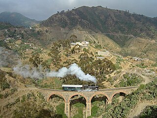
The Eritrean Railway is the only railway system in Eritrea. It was constructed between 1887 and 1932 during the Italian Eritrea colony and connects the port of Massawa with Asmara. Originally it also connected to Bishia. The line was partly damaged by warfare in subsequent decades, but was rebuilt in the 1990s. Vintage equipment is still used on the line.

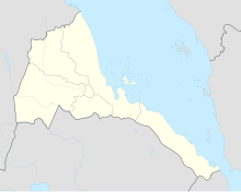
Gash-Barka is an administrative region of Eritrea. It is situated in the south-west of the country, bordering the Anseba region to the north, and the Maekel (Central) and Debub (Southern) regions to the east; the country of Sudan lies to the west and Ethiopia to the south.

Agordat, ኣቑርደት is a city in Gash-Barka, Eritrea. It was the capital of the former Barka Province, which was situated between the present-day Gash-Barka and Anseba regions.

Barentu is a town in north-western Eritrea, lying south of Agordat, and is the capital of Gash-Barka Region. The town is integrated with different types of tribes: Kunama, Nara, Tigre and Tigrinya being the most dominant.

The Barka River is a tributary river that flows from the Eritrean Highlands to the plains of Sudan. With a length of over 640 km, it rises just outside Asmara and flows in a northwestern direction through Agordat. The river merges with the Anseba River near the border with Sudan.
The Siege of Barentu took place in 1977 in and around the town of Barentu. It was jointly laid to siege by the Eritrean Liberation Front (ELF) and the Eritrean People's Liberation Front (EPLF) against the forces of Ethiopia.
The provinces of Eritrea existed since pre-Axumite times and became administrative provinces from Eritrea's incorporation as a colony of Italy until the conversion of the provinces into administrative regions. Many of the provinces had their own local laws since the 13th century.
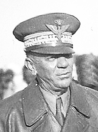
Luigi Frusci was an Italian military officer in the Italian Royal Army during the Italian conquest of Ethiopia and World War II. He was the last Italian Governor of Eritrea and Amhara.

RAF Castel Benito was an airport of Tripoli created by the Italians in Italian Libya. Originally, it was a small military airport named Castel Benito, but it was enlarged in the late 1930s and was later used by the British RAF after 1943. It was called RAF Castel Benito by the Allies.

The Royal Corps Of Eritrean Colonial Troops were indigenous soldiers from Eritrea, who were enrolled as askaris in the Royal Corps of Colonial Troops of the Royal Italian Army during the period 1889–1941.

The Second Battle of Agordat was fought in late December 1893, between Italian colonial troops and Mahdists from Sudan. Emir Ahmed Ali campaigned against the Italian forces in eastern Sudan and led about 10,000–12,000 men east from Kassala. This force encountered 2,400 Italians and their Eritrean askaris at Agordat, west of Asmara, commanded by Colonel Arimondi. Over 1,000 Dervishes, including the Emir, were killed in severe fighting. The outcome of the battle constituted "...the first decisive victory yet won by Europeans against the Sudanese revolutionaries,..."
Chaitén Airfield was an airport serving Chaitén, a town in the Los Lagos Region of Chile. The airport was damaged and closed after the 2008 eruption of Chaitén Volcano.
Teseney Airport is an airport serving Teseney, Eritrea. It has an asphalt runway of 2,330 meters.

The Agordat class was a pair of torpedo cruisers built by the Italian Regia Marina in the late 1890s. The two ships, Agordat and Coatit, were armed with twelve 76 mm (3 in) guns and two 450 mm (17.7 in) torpedo tubes. They proved to be too slow and have too short a cruising radius to be of much use, so their service careers were limited. Their most significant action came during the Italo-Turkish War of 1911–1912, where both ships were employed in shore bombardment duties. Neither ship saw action in World War I. Coatit was converted into a minelayer in 1919 and sold for scrapping the following year, while Agordat was rearmed as a gunboat in 1921; she followed her sister to the breakers in 1923.

The Battle of Agordat was fought near Agordat in Eritrea from 26 to 31 January 1941, by the Italian army and Royal Corps of Colonial Troops against British, Commonwealth and Indian forces, during the East African Campaign of the Second World War. The British had the advantage of breaking Italian codes and cyphers before the offensive and received copious amounts of information from Italian sources on the order of battle and plans of the Regia Aeronautica and the Italian army.
The Agordat Operation was part of the Eritrean War of Independence, and took place on 12 July 1962.