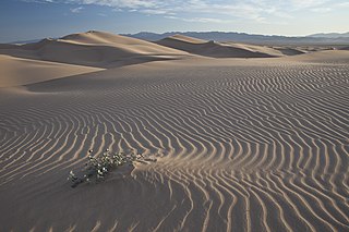
A dune is a landform, and is a large mass of wind-blown sand. Dunes are most common in deserted environments, such as the Sahara, and also near beaches. An area with dunes is called a dune system. The dynamic action of wind and water can sometimes causes the dunes to drift, which can have serious consequences. In physical geography, a dune is a hill of loose sand built by aeolian processes (wind) or the flow of water. Dunes occur in different shapes and sizes, formed by interaction with the flow of air or water. Dunes can be natural, but also man-made (artificial). Most kinds of dunes are longer on the stoss (upflow) side, where the sand is pushed up the dune, and have a shorter "slip face" in the lee side. The valley or trough between dunes is called a slack.

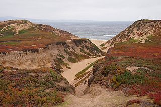
Barrier islands are coastal landforms and a type of dune system that are exceptionally flat or lumpy areas of sand that form by wave and tidal action parallel to the mainland coast. They usually occur in chains, consisting of anything from a few islands to more than a dozen. They are subject to change during storms and other action, but absorb energy and protect the coastlines and create areas of protected waters where wetlands may flourish. A barrier chain may extend uninterrupted for over a hundred kilometers, excepting the tidal inlets that separate the islands, the longest and widest being Padre Island of Texas. Sometimes an important inlet may close permanently, transforming an island into a peninsula, thus creating a barrier peninsula. The length and width of barriers and overall morphology of barrier coasts are related to parameters including tidal range, wave energy, sediment supply, sea-level trends, and basement controls. The amount of vegetation on the barrier has a large impact on the height and evolution of the island.

Grayton Beach State Park is a Florida State Park located between Panama City Beach and Destin, near the unincorporated area of Grayton Beach, on CR 30A, in northwestern Florida. Its sister park is Deer Lake State Park.

The Oregon Dunes National Recreation Area is located on the Oregon Coast, stretching approximately 40 miles (64 km) north of the Coos River in North Bend to the Siuslaw River in Florence, and adjoining Honeyman State Park on the west. It is part of Siuslaw National Forest and is administered by the United States Forest Service.
Anderson's gerbil is a species of gerbils distributed from Tunisia to Israel. Their habitats and diets are similar to other gerbils. The gestation period is 20–22 days and the average litter size is four or five. The IUCN formerly listed the junior synonym Gerbillus allenbyi as vulnerable.

The Swan Coastal Plain in Western Australia is the geographic feature which contains the Swan River as it travels west to the Indian Ocean. The coastal plain continues well beyond the boundaries of the Swan River and its tributaries, as a geological and biological zone, one of Western Australia's Interim Biogeographic Regionalisation for Australia (IBRA) regions. It is also one of the distinct physiographic provinces of the larger West Australian Shield division.
Fort Ord Dunes State Park is a state park in California, United States, along 4 miles (6.4 km) of coastline on Monterey Bay and created from part of the closed Fort Ord. The park includes a boardwalk, a path to the beach, a 4-mile (6.4 km) road for walking and biking, and interpretive exhibits describing its former use as a military training area. As the dunes are a nesting area for sensitive species, public access is limited to the paths and trails.

Cucq is a commune in the Pas-de-Calais department in the Hauts-de-France region of France.
Ashdod Sand Dune is a psammosere ecosystem close to the city of Ashdod on the Israeli Coastal Plain near the Mediterranean sea. It is south of Tel Aviv.

Sand dune stabilization is a Coastal management practice designed to prevent erosion of sand dunes. Sand dunes are common features of shoreline and desert environments. Dunes provide habitat for highly specialized plants and animals, including rare and endangered species. They can protect beaches from erosion and recruit sand to eroded beaches. Dunes are threatened by human activity, both intentional and unintentional. Countries such as the United States, Australia, Canada, New Zealand, the United Kingdom, and Netherlands, operate significant dune protection programs.
Buxton's jird is a species of rodent in the family Muridae. It is found in the Negev desert and the northern coastal parts of the Sinai peninsula.

Kurkar is the term used in Palestinian Arabic and modern Hebrew for the rock type of which lithified sea sand dunes consist. The equivalent term used in Lebanon is ramleh.

Ghabat Kafr Sur was a Palestinian village in the Tulkarm Subdistrict of Mandatory Palestine. It was depopulated during the 1948 Arab–Israeli War on May 15, 1948 under Operation Coastal Clearing. It was located 16 km southwest of Tulkarm.

The Guadalupe-Nipomo Dunes National Wildlife Refuge is a 2,553-acre (10.33 km2) protected area located along the Central Coast of California, in southern San Luis Obispo and northern Santa Barbara Counties.
The Battle of Rafah was a military engagement between the Israel Defense Forces and the Egyptian Army in the final stage of the 1948 Arab–Israeli War. It was fought on January 3–8, 1949, just south of Rafah, today in the Gaza Strip. The battle was initiated by Israel as part of Operation Horev, on the backdrop of the Sinai battles just before. The Israelis were hoping to encircle all Egyptian forces in Palestine and drive them back to Egypt.

The Naracoorte woodlands is an ecoregion in southern Australia. It covers the Naracoorte coastal plain in southeastern South Australia and southwestern Victoria. It is coterminous with the Naracoorte Coastal Plain IBRA region. Only 10% of the ecoregion's area still has its original vegetation; most has been converted to agriculture and pasture.
KwaZulu-Natal Dune Forest is a subtropical forest type that was once found almost continuously along the coastal dunes of KwaZulu-Natal, South Africa. This vegetation type develops in sheltered areas behind the littoral zone, where with some protection from the salt wind it may develop with canopies as tall as 30 m. It still exists in protected areas, but much has been degraded by human activity. Coastal dune forest covers approximately 1% of the land area of KwaZulu-Natal, and is a habitat type seriously threatened from human population pressure and development.
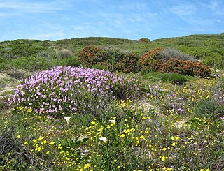
Cape Flats Dune Strandveld is an endangered vegetation type. This is a unique type of Cape Strandveld that is endemic to the coastal areas around Cape Town, including the Cape Flats.
Geography of the State of Palestine refers to the geographic, climatic and other properties of the areas claimed by State of Palestine.
