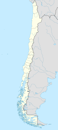
Los Lagos Region is one of Chile's 16 regions, which are first order administrative divisions, and comprises four provinces: Chiloé, Llanquihue, Osorno and Palena. The region contains the country's second largest island, Chiloé, and the second largest lake, Llanquihue. Its capital is Puerto Montt; other important cities include Osorno, Castro, Ancud, and Puerto Varas. The mainland portion of Los Lagos Region south of Reloncaví Sound is considered part of Patagonia.

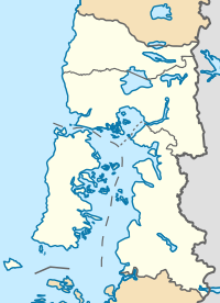
Osorno Province is one of the four provinces in the southern Chilean region of Los Lagos (X). The province has an area of 9,223.7 km2 (3,561 sq mi) and a population of 221,496 distributed across seven communes. The provincial capital is the city of Osorno.

Osorno is a city and commune in southern Chile and capital of Osorno Province in the Los Lagos Region. It had a population of 145,475, as of the 2002 census. It is located 945 kilometres (587 mi) south of the national capital of Santiago, 105 kilometres (65 mi) north of the regional capital of Puerto Montt and 260 kilometres (160 mi) west of the Argentine city of San Carlos de Bariloche, connected via International Route 215 through the Cardenal Antonio Samoré Pass. It is a gateway for land access to the far south regions of Aysén and Magallanes, which would otherwise be accessible only by sea or air from the rest of the country.

Puyehue National Park is located in the Andes mountain range, in Los Ríos and Los Lagos regions of Chile formerly referred to as the 10th region. The park boast 220,000 acres of natural thermal springs, volcanoes, and evergreen forests, after having been expanded in 1950 and 1981. The park is Chile's most visited national park with 400,000 people enjoying it each year. Puyehue National park forms part of the Reserve of Temperate Rainy Forest Biospheres of the Southern Andes. Chile Route 215 passes through the park, which connects with the Argentine Route 231 via Cardenal Antonio Samoré Pass.

Puyehue Lake, is an Andean piedmont lake on the border of Los Lagos Region with Los Ríos Region of Chile.
Cardenal Antonio Samoré Pass is one of the main mountain passes through the southern Andes along the border between Argentina and Chile.

The Antillanca Group is a volcanic group of scoria cones, maars and small stratovolcanoes, in Chile. Casablanca stratovolcano is the tallest volcano of the group, which shelters the Antillanca ski resort on its west flank. Aguas Calientes and Puyehue Hot springs also form part of this volcanic group. The complex encompasses 380 km2 and to the west is bordered by the lakes Puyehue and Rupanco.
Entre Lagos is the main town of Puyehue commune in Osorno Province of Los Lagos Region, Chile. It is 46 km (29 mi) east of Osorno, next to the entrance of the Pilmaiquén River at the western end of Puyehue Lake. It is the only town of any size on the lake.
Puyehue is a commune in Chile located in Osorno Province of Los Lagos Region. It is bordered to the south by Rupanco Lake, to the east by the Andes and Argentina, to the north by Puyehue Lake and to the west by Osorno commune. Cardenal Antonio Samoré Pass that links the Los Lagos Region to Argentina lies in the eastern tip of the commune. The comune is administered by Entre Lagos, the main town in Puyehue.

Casablanca is a holocene stratovolcano in the Andes of Los Lagos Region, Chile. It is located about 90 km east of the city of Osorno and host on its slopes the Antillanca ski resort. The complex erupted lavas with composition between basalt and andesite and has no recorded historical eruptions. Several scoria cones formed after the last ice age.

The Puyehue Hot Springs is a series of hot springs located 76 kilometers along Route 215-CH east of Osorno, a city 20 kilometers from Puerto Montt in the Los Lagos Region of southern Chile.

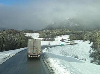
Route 215-CH is a branch line road going eastward from Osorno at Chile Highway 5 to Cardenal Antonio Samoré Pass at the border to Argentina. Apart from connecting southern Chile with Argentina, the road is also the main access to Antillanca ski resort, Puyehue National Park and the hot springs of Puyehue and Aguas Calientes.
Apoplania valdiviana is a species of moth belonging to the family Neopseustidae. It was described by Davis and Nielsen in 1985. It is known from the south-western part of the Neuquen Province of Argentina and the eastern part of the Osorno Province and the Cautin Province in Chile.

Agua Caliente in Maricopa County, Arizona on the border with Yuma County, is a place north of the Gila River near Hyder, Arizona. Named 'Santa Maria del Agua Caliente' in 1744 by Father Jacob Sedelmayer. In 1775, Father Francisco Garces used the current short form. The location was the site of a resort established at the site of nearby hot springs. Agua Caliente, a name derived from Spanish meaning "hot water", received its name from nearby hot springs which were originally used by the local Indians.

The Chilean Lake District is a zone in Southern Chile defined by its many lakes in the Andean foothills. The term is primarily used in tourism literature and advertising, in Chile Zona Sur is preferred as a geographical concept. The Chilean Lake District includes the cities of Temuco, Villarrica, Pucón, Valdivia, Osorno, Entre Lagos (Puyehue), Puerto Octay, Frutillar, Puerto Varas and Puerto Montt.
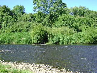
Damas River or de Las Damas River is a river of Chile located in Los Lagos Region. The river originates at an area known as Quema del Buey in the commune of Entre Lagos between Puyehue and Rupanco Lake. The river ends at its convergence with Rahue River. Damas River traverses the city of Osorno from east to west and separates the neighborhood of Pilauco from the rest of the city.