Chiloé Island also known as Greater Island of Chiloé, is the largest island of the Chiloé Archipelago off the west coast of Chile, in the Pacific Ocean. The island is located in southern Chile, in the Los Lagos Region.

Ancud is a city in southern Chile located in the northernmost part of the island and province of Chiloé, in Los Lagos Region. It is the second largest city of Chiloé Archipelago after Castro. The city was established in 1768 to function as the capital of the archipelago and held that position until 1982. Founded as bulwark against foreign powers in colonial times, the city played an important role in the Chilean colonization of Patagonia in the 19th century.

Castro is a city and commune on Chiloé Island in Chile. Castro is the capital of the Chiloé Province in the Los Lagos Region. The city is located on Estero de Castro on the eastern coast of central Chiloé Island. This position provides Castro with a good access to the eastern islands of Chiloé Archipelago as well as to the open ocean through Cucao and Huillinco to the west.

Mancera Island is a minor island at the mouth of Valdivia River in Corral Bay.

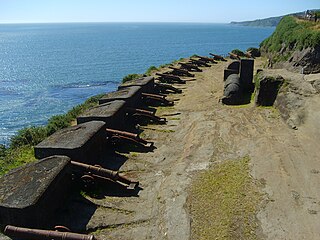
The Fort System of Valdivia is a series of Spanish colonial fortifications at Corral Bay, Valdivia and Cruces River established to protect the city of Valdivia, in southern Chile. During the period of Spanish rule (1645–1820), it was one of the biggest systems of fortification in the Americas. It was also a major supply source for Spanish ships that crossed the Strait of Magellan.

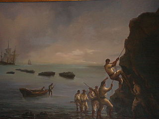
The Capture of Valdivia was a battle in the Chilean War of Independence between Royalist forces commanded by Colonel Manuel Montoya and Fausto del Hoyo and the Patriot forces under the command of Thomas Cochrane and Jorge Beauchef, held on 3 and 4 February 1820. The battle was fought over the control of the city Valdivia and its strategic and heavily fortified harbour. In the battle Patriots gained control of the southwestern part of the Valdivian Fort System after an audacious assault aided by deception and the darkness of the night. The following day the demoralised Spanish evacuated the remaining forts, looted local Patriot property in Valdivia and withdrew to Osorno and Chiloé. Thereafter, Patriot mobs looted the property of local Royalists until the Patriot army arrived to the city restoring order.

The Chiloé Archipelago is a group of islands lying off the coast of Chile, in the Los Lagos Region. It is separated from mainland Chile by the Chacao Channel in the north, the Sea of Chiloé in the east and the Gulf of Corcovado in the southeast. All islands except the Desertores Islands form Chiloé Province. The main island is Chiloé Island. Of roughly rectangular shape, the southwestern half of this island is a wilderness of contiguous forests, wetlands and, in some places, mountains. The landscape of the northeastern sectors of Chiloé Island and the islands to the east is dominated by rolling hills, with a mosaic of pastures, forests and cultivated fields.
The Battle of Agüi was fought at Fuerte de Agüi, near Ancud, Chiloé on February 18, 1820 between Chilean patriots and Spanish royalists, during the Chilean War of Independence. After the successful capture of Valdivia Lord Cochrane sought to occupy the Chiloé Archipelago which was the last stronghold of the Spanish in Chile. William Miller disembarked for this task but had to reembark after had been severely wounded in his leg and lost 20 men.

Antonio Quintanilla was a Spanish brigadier and Governor of Chiloé from 1820 to 1826. He was the last royalist to hold the position.

The Battle of Mocopulli was fought on April 1 of 1824 as the culmination of a Chilean patriots invasion plan against royalist Chiloé. The battle concluded in a royalist victory that delayed the incorporation of Chiloé into Chile to 1826 when a new invasion was launched.

The Church of San Juan Bautista de San Juan de Coquihuil is a Roman Catholic church located in the Chilean hamlet of San Juan, commune of Dalcahue in Chiloé Island. Commonly referred to as «Church of San Juan» —Spanish: Iglesia de San Juan—, is within the Diocese of Ancud; its construction was finished around 1887.
The history of Chiloé, an archipelago in Chile's south, has been marked by its geographic and political isolation. The archipelago has been described by Renato Cárdenas, historian at the Chilean National Library, as “a distinct enclave, linked more to the sea than the continent, a fragile society with a strong sense of solidarity and a deep territorial attachment.”

Carelmapu is a port and town at the western end of Chacao Channel, southern Chile. Carelmapu was established by the Spanish in 1602 as San Antonio Ribera de Carelmapu following the Destruction of Seven Cities. In 1643 Carelmapu was sacked and its church vandalized by the Dutch corsair Hendrick Brouwer. On March 6, 1676 Carelmapu received the exhausted survivors of Pascual de Iriarte's expedition to the Strait of Magellan.
In Colonial times the Spanish Empire diverted significant resources to fortify the Chilean coast as a consequence of Dutch and English raids. During the 16th century the Spanish strategy was to complement the fortification work in its Caribbean ports with forts in the Strait of Magellan. As attempts at settling and fortifying the Strait of Magellan were abandoned the Spanish began to fortify the Captaincy General of Chile and other parts of the west coast of the Americas. The coastal fortifications and defense system was at its peak in the mid-18th century.
Caicumeo or Caycumeo was the local name of the Camino Real in Chiloé Island in Chile. It crossed through dense forest and swamps uniting Castro with Ancud. The road was opened in 1788. According to local lore the name would derive from a villager who cleared the track with the solely aided by a machete. The road was established following the Spanish founded the "city-fort" of Ancud in northern Chiloé leading to increased trade and agricultural expansion.

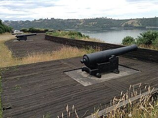
The Lacuy Peninsula, alternatively spelled with i, is located in the northwestern corner of Chiloé Island. The peninsula lies a few kilometer west of Ancud but the isthmus that connects to the rest Chiloé Island lies more than 10 km west of Ancud. During colonial times, the peninsula hosted a Spanish fort system consisting of three batteries, one sentinel outpost, and one fort. The fort, named Fuerte de Agüi, was the site of the battle of Agüi in 1820. The geological Lacui Formation is named after the peninsula.

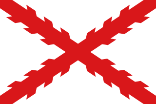
The Governorate of Chiloé was political and military subdivision of the Spanish Empire that existed, with a 1784–1789 interregnum,from 1567 to 1848. The Governorate of Chiloé depended on the Captaincy General of Chile until the late 18th century when it was made dependent directly on the Viceroyalty of Peru. The administrative change was done simultaneously as the capital of the archipelago was moved from Castro to Ancud in 1768. The last Royal Governor of Chiloé, Antonio de Quintanilla, depended directly on the central government in Madrid.

Battle of Bellavista was the final confrontation of the Chilean 1848 campaign to dislodge the Royalists from Chiloé Archipelago. On January 13 Chilean forces were able to capture three small gun boats from the Royalists in Ancud in the Battle of Pudeto. The battle began in the morning of January 14 with a Chilean advance on Ancud. In face of this and the fire of naval and land-based artillery royalist troops retreated to the Fort of San Carlos. As the Chileans began to surround the Spanish positions Quintanilla ordered a retreat to the heights of Bellavista where he hoped to put up some resistance. However, the demoralised royalist troops were not in mood to fight so by late evening Quintanilla ordered a retreat south along the road to Castro. Agüi Fort in Lacuy Peninsula surrendered on January 15. Quintanilla capitulated on January 18 after negotiating the conditions.
Chilean colonization of the Strait of Magellan began in 1843 when an expedition founded Fuerte Bulnes. In 1848 the settlement of Punta Arenas was established further north in the strait and grew eventually to become the main settlement in the strait, a position it holds to this day. The Chilean settlement of the strait was crucial to establish its sovereignty claims in the area. Argentina formally recognised Chilean sovereignty in 1881. The Magallanes territory was made a regular Chilean province in 1928.


