Related Research Articles

Bear Creek is a census-designated place (CDP) in Kenai Peninsula Borough, Alaska, United States. At the 2020 census the population was 2,129 up from 1,956 in 2010. Bear Creek is a few miles north of Seward near the stream of the same name and its source, Bear Lake.

Halibut Cove is a census-designated place (CDP) in Kenai Peninsula Borough, Alaska, United States. The population was 76 at the 2010 census, up from 35 in 2000.

Hope is a census-designated place (CDP) in Kenai Peninsula Borough in the U.S. state of Alaska. It is eighty-seven miles south from Anchorage. As of the 2010 census the population was 192, up from 137 in 2000.

Lowell Point is a census-designated place (CDP) in Kenai Peninsula Borough, Alaska, United States, just outside Seward. At the 2010 census the population was 80, down from 92 in 2000.

Seward is an incorporated home rule city in Alaska, United States. Located on Resurrection Bay, a fjord of the Gulf of Alaska on the Kenai Peninsula, Seward is situated on Alaska's southern coast, approximately 120 miles (190 km) by road from Alaska's largest city, Anchorage.

The Kenai Peninsula is a large peninsula jutting from the coast of Southcentral Alaska. The name Kenai is derived from the word "Kenaitze" or "Kenaitze Indian Tribe", the name of the Native Athabascan Alaskan tribe, the Kahtnuht’ana Dena’ina, who historically inhabited the area. They called the Kenai Peninsula Yaghanen.

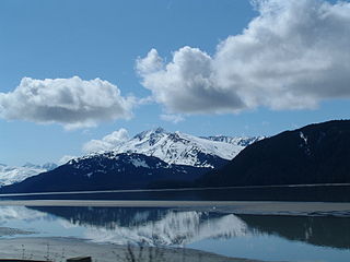
Kenai Fjords National Park is an American national park that maintains the Harding Icefield, its outflowing glaciers, and coastal fjords and islands. The park covers an area of 669,984 acres on the Kenai Peninsula in south-central Alaska, west of the town of Seward.
Turnagain Arm is a waterway into the northwestern part of the Gulf of Alaska. It is one of two narrow branches at the north end of Cook Inlet, the other being Knik Arm. Turnagain is subject to climate extremes and large tide ranges.

Portage Glacier is a glacier on the Kenai Peninsula of the U.S. state of Alaska and is included within the Chugach National Forest. It is located south of Portage Lake and 6 km (4 mi) west of Whittier.

Resurrection Bay, also known as Blying Sound, and Harding Gateway in its outer reaches, is a fjord on the Kenai Peninsula of Alaska, United States. Its main settlement is Seward, located at the head of the bay. The bay received its name from Alexandr Baranov, who was forced to retreat into the bay during a bad storm in the Gulf of Alaska. When the storm settled it was Easter Sunday, so the bay and nearby Resurrection River were named in honor of it. Harding Gateway refers to the passage between Rugged and Cheval Islands.

Arrowsmith Peninsula is a cape about 40 miles (64 km) long on the west coast of Graham Land, west of Forel Glacier, Sharp Glacier and Lallemand Fjord, and northwest of Bourgeois Fjord, with Hanusse Bay lying to the northwest. It was surveyed by the Falkland Islands Dependencies Survey (FIDS) in 1955-58 and named for Edwin Porter Arrowsmith, Governor of the Falkland Islands.

The Aialik Glacier is a glacier in the Kenai Peninsula Borough of Alaska. It drains into Aialik Bay. Part of Kenai Fjords National Park, it drains the Harding Icefield. Aialik Glacier, a little over 15 miles from Seward, is the largest glacier in Aialik Bay, located in Kenai Fjords National Park. While fairly stable, the glacier calves most actively in May and June.

Holgate Glacier is a glacier located in the U.S. state of Alaska, in Kenai Fjords National Park. It flows outward from the Harding Icefield toward Holgate Arm of Aialik Bay. Tour boats from Seward, Alaska offer tourists the opportunity to view the glacier.

Resurrection Creek is a waterway in the Kenai Peninsula, Alaska, US. Along with Bear Creek, Sixmile Creek, and Glacier Creek, it is a tributary of Turnagain Arm. The stream's watershed drains 161 square miles (420 km2) on the north side of the Kenai Peninsula, and the community of Hope, Alaska is located at the creek's mouth. The Hope Highway passes alongside Resurrection Creek.
Day Harbor is a bay on the Kenai Peninsula of Alaska, United States. It received its name in 1787 from Captain Portlock, due to the fact that travel to the head of the bay from Seward typically takes 12 hours. The bay is 25 miles from Seward, and is accessible only by boat. It is a gently curving J-shaped bay separated on the west from nearby Resurrection Bay by the Resurrection Peninsula. Recreational boaters often anchor at one of the two State Marine Parks due to the often choppy seas and unstable weather of outer Day Harbor. Lesser used anchorages on the eastern shore include Anchor Cove and Bowen Anchorage. Popular activities in the bay include hiking to Ellsworth Lake at the head of the bay where the retreating Ellsworth Glacier calves.
Humpy Cove is an inlet of Resurrection Bay on the Kenai Peninsula of the U.S. state of Alaska. Located 11 miles from Seward, it has the shape of a whale's tail, and consists of two smaller bays. The cove is often used as an anchorage for recreational boaters. It received its name from the plentiful returns of pink salmon that spawn in Humpy Creek, the inflow of the southern bay. The cove is a popular tourist destination as well, due to Orca Island Cabins and kayak tours offered by Miller's Landing. Humpy Cove has runs of rockfish, halibut, coho salmon, chinook salmon, and chum salmon as well as pinks, and a popular fishing spot is near the Iron Door, the remains of a searchlight and bunker from World War II. The cove contains the only road on the Resurrection Peninsula, a stretch of pavement leading to the aforementioned searchlight.
Resurrection Peninsula is a peninsula on the larger Kenai Peninsula of the U.S. state of Alaska, which lies roughly 8 miles southeast of Seward. It contains very rugged geography, with very little flat land existing between sheer peaks and the deep inlets of Resurrection Bay to the west, and Day Harbor to the east. Due to the geographical nature of the peninsula, it is uninhabited, although numerous cabins, state parks, and general private in holdings exist. All land here is accessible by boat only. There is no concrete measurement of the exact of the landmass, however, the Alaska Department of Fish and Game has a management area which encompasses the landmass as well as lands that are not usually considered part of a peninsula. The land which better fits the definition is roughly 10 miles long, running from near Thumb Cove and Talus Bay to Cape Resurrection at its southern extremity. Slightly less than half of the land on the Resurrection Peninsula is part of the Chugach National Forest's southern terminus.

The Fourth of July Creek is a creek on the Kenai Peninsula in Alaska. It rises on the upper Resurrection Peninsula from various glaciers in the Chugach Mountains that drain the Sargeant Icefield and flows 5 miles (8.0 km) to empty into Resurrection Bay near Seward. Fourth of July Creek formed some time after 1850, when Godwin Glacier retreated from the shores of Resurrection Bay, uncovering the stream and the broad valley it flows through. The creek was formerly known as the Godwin River, before the aforementioned glacier split into two valleys creating a separate tributary of the waterway, today known as Godwin Creek.
Aialik Bay, also known as Dora Passage between Harbor Island and the Harris Peninsula, is a fjord on the Kenai Peninsula of Alaska, United States. It has no permanent settlements, but there are two public use cabins located on the bay, one at its head and another at Holgate Arm. The Kenai Fjords lodge also hosts visitors. Aialik Bay is 33 miles south of Seward. The bay received its name from Russians recording the indigenous name as "Ayalyk Bay". It is likely that the bay once terminated at Aialik Sill, by Pedersen Lagoon prior to the year 1700. At this sill, the bay's bottom rises to less than 60 feet below sea level, and is as shallow as 18 feet deep in some places. Aialik Glacier, which has created the bay via the process of overdeepening, has since retreated by 4.5 miles.
References
- ↑ "Aialik Peninsula Topo Map, Kenai Peninsula County AK (Blying Sound D-7 Area)". TopoZone. Retrieved 2022-09-23.
Coordinates: 59°59′31″N149°15′36″W / 59.992°N 149.260°W
| | This article about a location in the Kenai Peninsula Borough, Alaska is a stub. You can help Wikipedia by expanding it. |