
Labrador is a geographic and cultural region within the Canadian province of Newfoundland and Labrador. It is the primarily continental portion of the province and constitutes 71% of the province's area but is home to only 6% of its population. It is separated from the island of Newfoundland by the Strait of Belle Isle. It is the largest and northernmost geographical region in the four Atlantic provinces.

Northern Canada, colloquially the North or the Territories, is the vast northernmost region of Canada, variously defined by geography and politics. Politically, the term refers to the three territories of Canada: Yukon, Northwest Territories and Nunavut. This area covers about 48 per cent of Canada's total land area, but has less than 0.5 per cent of Canada's population.
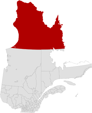
Nunavik is an area in Canada which comprises the northern third of the province of Quebec, part of the Nord-du-Québec region and nearly coterminous with Kativik. Covering a land area of 443,684.71 km2 (171,307.62 sq mi) north of the 55th parallel, it is the homeland of the Inuit of Quebec and part of the wider Inuit Nunangat. Almost all of the 14,045 inhabitants of the region, of whom 90% are Inuit, live in fourteen northern villages on the coast of Nunavik and in the Cree reserved land (TC) of Whapmagoostui, near the northern village of Kuujjuarapik.

The Kativik Regional Government is the representative regional authority for most of the Nunavik region of Quebec. Nunavik is the northern half of the Nord-du-Québec administrative region and includes all the territory north of the 55th parallel. The administrative capital is Kuujjuaq, on the Koksoak River, about 50 kilometres inland from the southern end of the Ungava Bay.

Southampton Island is a large island at the entrance to Hudson Bay at Foxe Basin. One of the larger members of the Arctic Archipelago, Southampton Island is part of the Kivalliq Region in Nunavut, Canada. The area of the island is stated as 41,214 km2 (15,913 sq mi) by Statistics Canada. It is the 34th largest island in the world and Canada's ninth largest island. The only settlement on Southampton Island is Coral Harbour, called Salliq in Inuktitut.

Coats Island lies at the northern end of Hudson Bay in the Kivalliq Region of Nunavut. At 5,498 km2 (2,123 sq mi) in size, it is the 107th largest island in the world, and Canada's 24th largest island.

Waskaganish is a Cree community of over 2,500 people at the mouth of the Rupert River on the south-east shore of James Bay in Northern Quebec, Canada. Waskaganish is part of the territory referred to as "Eeyou Istchee" encompassing the traditional territories of Cree people in the James Bay regions of what is now Northern Quebec and Ontario.
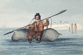
The Sadlermiut were an Inuit group living in near isolation mainly on and around Coats Island, Walrus Island, and Southampton Island in Hudson Bay. They survived into the early 20th century and were thought by some to have been the last remnants of the Dorset culture as they had preserved a culture and dialect distinct from the mainland Inuit. Despite their culture and local traditions seeming to show combined elements of both the Dorset and Thule societies, genetic studies show no Dorset admixture and prove a sole Inuit ancestry leading many to conclude the cultural difference may be entirely due to their isolation from the mainland Inuit. Research published in 2015 found that the Sadlermiut were genetically Thule who had somehow acquired Dorset cultural features, such as stone technology. It remains a mystery how they acquired Dorset technology in the absence of obvious genetic admixture such as through intermarrying.
The James Bay and Northern Quebec Agreement is an Aboriginal land claim settlement, approved in 1975 by the Cree and Inuit of northern Quebec, and later slightly modified in 1978 by the Northeastern Quebec Agreement, through which Quebec's Naskapi First Nation joined the agreement. The agreement covers economic development and property issues in northern Quebec, as well as establishing a number of cultural, social and governmental institutions for Indigenous people who are members of the communities involved in the agreement.

Whale Cove, is a hamlet located 74 km (46 mi) south southwest of Rankin Inlet, 145 km (90 mi) northeast of Arviat, in the Kivalliq Region, Nunavut, Canada, on the western shore of Hudson Bay.
Ivujivik is a northern village in Nunavik, Quebec, and the northernmost settlement in any Canadian province, although there are settlements further north in the territories. Its population in the 2021 Canadian census was 412.
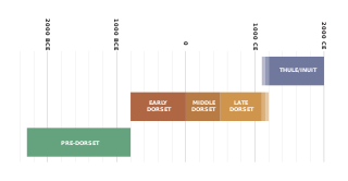
The history of Nunavut covers the period from the arrival of the Paleo-Eskimo thousands of years ago to present day. Prior to the colonization of the continent by Europeans, the lands encompassing present-day Nunavut were inhabited by several historical cultural groups, including the Pre-Dorset, the Dorsets, the Thule and their descendants, the Inuit.
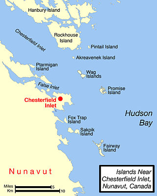
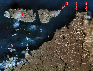
Chesterfield Inlet is an inlet in Kivalliq Region, Nunavut, Canada. It is an arm of northwestern Hudson Bay, and the end point of the Thelon River after its passage through Baker Lake. Cross Bay, a large widening of the inlet, occurs 30 kilometres (19 mi) east of Baker Lake. There are several islands located within the inlet.

Cape Fullerton is a cape and peninsula in the Kivalliq Region of Nunavut, Canada located on the northwest shores of Hudson Bay on Roes Welcome Sound and includes Fullerton Harbour. Today it is part of Ukkusiksalik National Park. Although Cape Fullerton was traditionally home to migrant Inuit including the Aivilingmiut and the Qaernermiut, today the nearest permanently populated settlement is Chesterfield Inlet, roughly 100 km (62 mi) to the southwest.

Kivallirmiut, also called the Caribou Inuit, barren-ground caribou hunters, are Inuit who live west of Hudson Bay in Kivalliq Region, Nunavut, between 61° and 65° N and 90° and 102° W in Northern Canada.

Captain George Comer was considered the most famous American whaling captain of Hudson Bay, and the world's foremost authority on Hudson Bay Inuit in the early 20th century.
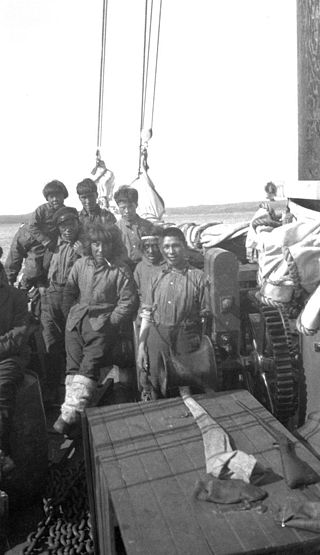
Fort Chesterfield, known as Umiajuatnak by the Inuit, was a Hudson's Bay Company motor schooner which distributed supplies arriving in Chesterfield Inlet to isolated communities along Hudson Bay, including Repulse Bay, Eskimo Point, Coral Harbour, Fullerton Harbour, Wager Bay, and the inland community of Baker Lake, during the 1920s. It established a transportation and communications network for the entire region.
The Digges Islands are members of the Arctic Archipelago in the territory of Nunavut. The two islands, West Digges and East Digges, are located in Digges Sound, an arm of Hudson Bay, where the strong currents of the bay meet Hudson Strait.
Amadjuak is a former Inuit settlement on southern Baffin Island in the Canadian territory of Nunavut. Amadjuak Bay is 4 km (2.5 mi) south, on Hudson Strait.

Killiniq is a former Inuit settlement, weather station, trading post, missionary post, fishing station, and Royal Canadian Mounted Police post on Killiniq Island. Previously within Labrador, and then the Northwest Territories, it is now situated within the borders of Nunavut. The community closed in 1978.
