Ajnale

Last updated
Ajnale
village
India Maharashtra location map.svg
Red pog.svg
Ajnale
Location in Maharashtra, India
India location map.svg
Red pog.svg
Ajnale
Ajnale (India)
Coordinates: 20°49′N74°35′E / 20.82°N 74.59°E / 20.82; 74.59 Coordinates: 20°49′N74°35′E / 20.82°N 74.59°E / 20.82; 74.59
CountryFlag of India.svg  India
State Maharashtra
District Dhule
Talukas Dhule
Population (2001)
  Total 871
Languages
  Official Marathi
Time zone IST (UTC+5:30)

Ajnale is a small village in the state of Maharashtra, India. It is located in the Dhule taluka of Dhule District in Maharashtra.
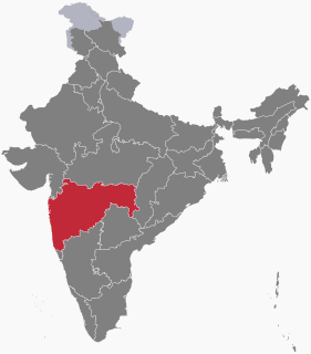
Maharashtra State in western, southern and central India

Maharashtra is a state considered to be part of western, central, southern and south-central India. It is the second-most populous state and third-largest state by area in India. Spread over 307,713 km2 (118,809 sq mi), it is bordered by the Arabian Sea to the west, the Indian states of Karnataka and Goa to the south, Telangana and Chhattisgarh to the east, Gujarat and Dadra and Nagar Haveli to the north west, and Madhya Pradesh to the north. It is also the world's second-most populous subnational entity. It was formed by merging the western and south-western parts of the Bombay State, Berar and Vidarbha, and the north-western parts of the Hyderabad State and splitting Saurashtra by the States Reorganisation Act. It has over 112 million inhabitants and its capital, Mumbai, has a population around 18 million making it the most populous urban area in India. Nagpur hosts the winter session of the state legislature. Pune is known as 'Oxford of the East' due to the presence of several well-known educational institutions.

India Country in South Asia

India, also known as the Republic of India, is a country in South Asia. It is the seventh largest country by area and with more than 1.3 billion people, it is the second most populous country and the most populous democracy in the world. Bounded by the Indian Ocean on the south, the Arabian Sea on the southwest, and the Bay of Bengal on the southeast, it shares land borders with Pakistan to the west; China, Nepal, and Bhutan to the northeast; and Bangladesh and Myanmar to the east. In the Indian Ocean, India is in the vicinity of Sri Lanka and the Maldives, while its Andaman and Nicobar Islands share a maritime border with Thailand and Indonesia.

Dhule City in Maharashtra, India

Dhule is the one of the important cities of India,located in the Dhule District in the northwestern part of Maharashtra state, India known as West Khandesh, situated on the banks of Panzara River. Dhule is one of the top cities of Maharashtra as well as India.

Contents

Location

Ajnale is located on the Maharashtra State Highway 10 (MH SH 10).

Demographics

As of 2001 census, Ajnale had a population of 871 with 436 males and 435 females. Males constitute 50% of the population and females 50%. Ajnale has an average literacy rate of 0%, lower than the national average of 59.5%. Male Literacy is 0%, and female literacy is 0%. In Ajnale, 7.57% of the population is under 6 years of age. Ajnale has an average birth rate of 0% and an average death rate of 0%.

Census Acquiring and recording information about the members of a given population

A census is the procedure of systematically acquiring and recording information about the members of a given population. The term is used mostly in connection with national population and housing censuses; other common censuses include agriculture, business, and traffic censuses. The United Nations defines the essential features of population and housing censuses as "individual enumeration, universality within a defined territory, simultaneity and defined periodicity", and recommends that population censuses be taken at least every 10 years. United Nations recommendations also cover census topics to be collected, official definitions, classifications and other useful information to co-ordinate international practice.

Birth rate total number of live births per 1,000 of a population in a certain period of time (usually a year)

The birth rate is the total number of live births per 1,000 in a population in a year or period. The rate of births in a population is calculated in several ways: live births from a universal registration system for births, deaths, and marriages; population counts from a census, and estimation through specialized demographic techniques. The birth rate are used to calculate population growth.

There are total of 173 households in the village and the village border area is spread in the area of 1,612 hectares.

Administration

Ajnale has as Village Gram Panchayat for day-to-day administration. The District Zilla Panchayat headquarters is at Dhule and the Block Panchayat is also at Dhule.

Ajnale has no commercial banks, co-operative banks, agricultural credit societies, non-agricultural credit societies or other credit societies present within the village.

Transport

Rail

Ajnale has no railway station of its own, the closest railway station is Dhule which is 14 mi (23 km) from the village.

Road

Ajnale is connected by the State Transport Buses that ply between Dhule, Kusumba & Malegaon.

Air

Ajnale has no airport of its own, the closest airport is at Dhule.

See also

Related Research Articles

Navapur municipality in Maharashtra, India

Navapur is a nagar panchayat (municipality) and headquarters for Navapur Taluka in Nandurbar district, in the state of Maharashtra, India.

Ekdil city in Uttar Pradesh, India

Ekdil is a town and a nagar panchayat in Etawah district in the state of Uttar Pradesh, India. This place was established by the Ekdil Khan. It was earlier known as Sarai Rupa. In the 17th century, a eunuch named Ekdil Khan came here, and built a new sarai, which he named Ekdil, This town is located at National Highway No.2. It is just 9 kilometers from Etawah. It has a small railway station on the north side named EKDIL. Distance of railway station 3 kilometers from Ekdil town.Ekdil had a population of 11310.

Kantaphod city in Madhya Pradesh, India

Kantaphod is a small village and a nagar panchayat in Dewas district in the Indian state of Madhya Pradesh. It is located on the foot of Malwa plateau on the bank of Chandrakeshar river.

Khetia city in Madhya Pradesh, India

Khetia is a town and a nagar panchayat in the Barwani district in the Indian central western state of Madhya Pradesh.

Nallur, Kanyakumari Town in Tamil Nadu, India

Nallur (Nalloor) is a panchayat town in Kanniyakumari district in the Indian state of Tamil Nadu.

Panapakkam Town panchayat in Tamil Nadu, India

Panapakkam is a panchayat town in Nemili Taluk of Vellore district in the Indian state of Tamil Nadu.This town is located in the Vellore District about 85 kilometres from the state capital of Chennai. Panapakkam is supposedly one of the hottest towns in India, where the temperature can exceed 43 °C (110 °F) for several days in peak of the summer.

Partur Town in Maharashtra, India

Partur is a town with municipal council in Jalna district in the Indian state of Maharashtra.

Gotane village in Maharashtra, India

Gotane is a small village in the state of Maharashtra, India. It is located in the Dhule taluka of Dhule District in Maharashtra.

Khede village in Maharashtra, India

Khede is a small village in the state of Maharashtra, India. It is located in the Dhule taluka of Dhule District in Maharashtra.

Khaede village in Maharashtra, India

Khede or Mauje Khede is a small village in Niphad Taluka of Nashik district in Maharashtra State of India. Located on the left bank of Vinata River, Khede is also known for temple of Shri Hinglaj Mata.

Kapadne village in Maharashtra, India

Kapadne is a small village in the state of Maharashtra, India. It is located in the Dhule taluka of Dhule district in Maharashtra.

Betawad town in Maharashtra, India

Betawad is a village in Sindkheda Taluka in Dhule District of Maharashtra State, India. It belongs to Khandesh and Northern Maharashtra region. It belongs to Nashik Division.

Sadapur Village in Maharashtra, India

Sadapur (Marathi:सैदापूर) is a village in India. It is situated in the Mawal taluka of Pune District in the state of Maharashtra.

Shilimb Village in Maharashtra, India

Shilimb (Marathi:शिलिंब) is a village in India. It is situated in the Mawal taluka of Pune District in the state of Maharashtra.

Shindgaon Village in Maharashtra, India

Shindgaon (Marathi:शिंडगाव) is a village in India. It is situated in the Mawal taluka of Pune District in the state of Maharashtra.

Shirdhe Village in Maharashtra, India

Shirdhe (Marathi:शिर्ध्ये) is a village in India. It is situated in the Mawal taluka of Pune District in the state of Maharashtra.

Somavadi Village in Maharashtra, India

Somavadi (Marathi:सोमवाडी) is a village in India. It is situated in the Mawal taluka of Pune District in the state of Maharashtra.

Shivane, Maval Village in Maharashtra, India

Shivane (Marathi:शिवाने) is a village in India. It is situated in the Mawal taluka of Pune District in the state of Maharashtra.

Thakursai Village in Maharashtra, India

Thakursai (Marathi:ठाकूरसाई) is a village in India. It is situated in the Mawal taluka of Pune District in the state of Maharashtra.

Bisauri Village in Uttar Pradesh, India

Bisauri is a village of the Jaunpur district, Uttar Pradesh, Northern India. Bisauri's Postal Index Number is 222129 and its post office is at Patrahi. The village is also a Gram Panchayat, comprising itself and the village of Tiwaripur.

References